You are here: Home > Network List > IC - New China Digital Seismograph Network Stations List
> Station HIA Hailar, Neimenggu Autonomous Region, China > Earthquake Result Viewer
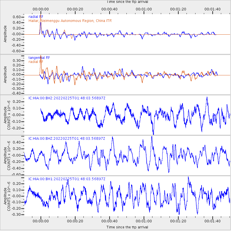
HIA Hailar, Neimenggu Autonomous Region, China - Earthquake Result Viewer
*The percent match for this event was below the threshold and hence no stack was calculated.
| Earthquake location: |
Northern Sumatra, Indonesia |
| Earthquake latitude/longitude: |
0.2/100.1 |
| Earthquake time(UTC): |
2022/02/25 (056) 01:39:27 GMT |
| Earthquake Depth: |
12 km |
| Earthquake Magnitude: |
6.2 mww |
| Earthquake Catalog/Contributor: |
NEIC PDE/us |
|
| Network: |
IC New China Digital Seismograph Network |
| Station: |
HIA Hailar, Neimenggu Autonomous Region, China |
| Lat/Lon: |
49.27 N/119.74 E |
| Elevation: |
620 m |
|
| Distance: |
51.7 deg |
| Az: |
16.291 deg |
| Baz: |
205.358 deg |
| Ray Param: |
$rayparam |
*The percent match for this event was below the threshold and hence was not used in the summary stack. |
|
| Radial Match: |
69.40875 % |
| Radial Bump: |
400 |
| Transverse Match: |
52.492447 % |
| Transverse Bump: |
400 |
| SOD ConfigId: |
26694651 |
| Insert Time: |
2022-03-11 01:44:22.811 +0000 |
| GWidth: |
2.5 |
| Max Bumps: |
400 |
| Tol: |
0.001 |
|
Signal To Noise
| Channel | StoN | STA | LTA |
| IC:HIA:00:BHZ:20220225T01:48:03.56897Z | 1.9965173 | 2.105556E-7 | 1.05461446E-7 |
| IC:HIA:00:BH1:20220225T01:48:03.56897Z | 1.1853178 | 1.0633043E-7 | 8.970627E-8 |
| IC:HIA:00:BH2:20220225T01:48:03.56897Z | 1.8621902 | 1.01626036E-7 | 5.457339E-8 |
| Arrivals |
| Ps | |
| PpPs | |
| PsPs/PpSs | |


