You are here: Home > Network List > IC - New China Digital Seismograph Network Stations List
> Station HIA Hailar, Neimenggu Autonomous Region, China > Earthquake Result Viewer
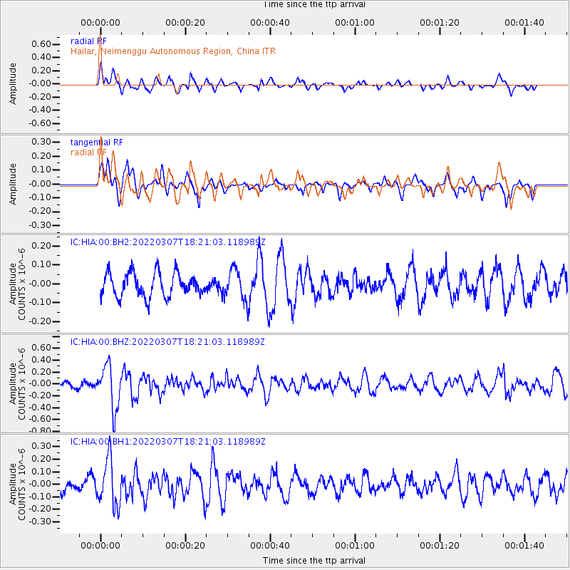
HIA Hailar, Neimenggu Autonomous Region, China - Earthquake Result Viewer
*The percent match for this event was below the threshold and hence no stack was calculated.
| Earthquake location: |
Talaud Islands, Indonesia |
| Earthquake latitude/longitude: |
2.7/125.7 |
| Earthquake time(UTC): |
2022/03/07 (066) 18:13:10 GMT |
| Earthquake Depth: |
57 km |
| Earthquake Magnitude: |
5.3 Mww |
| Earthquake Catalog/Contributor: |
NEIC PDE/us |
|
| Network: |
IC New China Digital Seismograph Network |
| Station: |
HIA Hailar, Neimenggu Autonomous Region, China |
| Lat/Lon: |
49.27 N/119.74 E |
| Elevation: |
620 m |
|
| Distance: |
46.6 deg |
| Az: |
354.591 deg |
| Baz: |
171.735 deg |
| Ray Param: |
$rayparam |
*The percent match for this event was below the threshold and hence was not used in the summary stack. |
|
| Radial Match: |
72.09356 % |
| Radial Bump: |
400 |
| Transverse Match: |
81.33574 % |
| Transverse Bump: |
394 |
| SOD ConfigId: |
26694651 |
| Insert Time: |
2022-03-21 18:18:41.002 +0000 |
| GWidth: |
2.5 |
| Max Bumps: |
400 |
| Tol: |
0.001 |
|
Signal To Noise
| Channel | StoN | STA | LTA |
| IC:HIA:00:BHZ:20220307T18:21:03.118989Z | 7.2138424 | 3.669086E-7 | 5.0861743E-8 |
| IC:HIA:00:BH1:20220307T18:21:03.118989Z | 3.7836237 | 1.8890161E-7 | 4.9926108E-8 |
| IC:HIA:00:BH2:20220307T18:21:03.118989Z | 1.2974375 | 8.181553E-8 | 6.305932E-8 |
| Arrivals |
| Ps | |
| PpPs | |
| PsPs/PpSs | |


