You are here: Home > Network List > XM99 - Rio Grande Seismic Transect Stations List
> Station AZ46 Arizona46 > Earthquake Result Viewer
AZ46 Arizona46 - Earthquake Result Viewer
| Earthquake location: |
Near Coast Of Ecuador |
| Earthquake latitude/longitude: |
-0.2/-80.6 |
| Earthquake time(UTC): |
2000/09/28 (272) 23:23:43 GMT |
| Earthquake Depth: |
23 km |
| Earthquake Magnitude: |
5.8 MB, 6.0 MS, 6.6 MW, 6.4 MW |
| Earthquake Catalog/Contributor: |
WHDF/NEIC |
|
| Network: |
XM Rio Grande Seismic Transect |
| Station: |
AZ46 Arizona46 |
| Lat/Lon: |
36.55 N/109.23 W |
| Elevation: |
2009 m |
|
| Distance: |
45.2 deg |
| Az: |
327.05 deg |
| Baz: |
137.51 deg |
| Ray Param: |
0.07138895 |
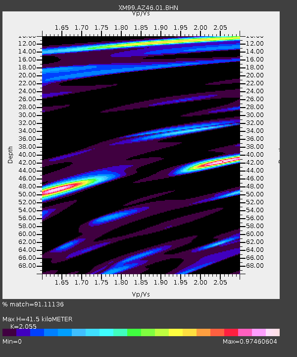
| Estimated Moho Depth: |
41.5 km |
| Estimated Crust Vp/Vs: |
2.06 |
| Assumed Crust Vp: |
6.476 km/s |
| Estimated Crust Vs: |
3.151 km/s |
| Estimated Crust Poisson's Ratio: |
0.34 |
|
| Radial Match: |
91.11136 % |
| Radial Bump: |
400 |
| Transverse Match: |
72.97923 % |
| Transverse Bump: |
400 |
| SOD ConfigId: |
16820 |
| Insert Time: |
2010-02-26 17:20:39.884 +0000 |
| GWidth: |
2.5 |
| Max Bumps: |
400 |
| Tol: |
0.001 |
|

Signal To Noise
| Channel | StoN | STA | LTA |
| XM:AZ46:01:BHN:20000928T23:31:27.821008Z | 1.289676 | 1.0302711E-7 | 7.988604E-8 |
| XM:AZ46:01:BHE:20000928T23:31:27.821008Z | 0.7834301 | 8.4624205E-8 | 1.0801756E-7 |
| XM:AZ46:01:BHZ:20000928T23:31:27.821008Z | 3.2371392 | 2.0727919E-7 | 6.4031596E-8 |
| Arrivals |
| Ps | 7.1 SECOND |
| PpPs | 19 SECOND |
| PsPs/PpSs | 26 SECOND |


