You are here: Home > Network List > XM99 - Rio Grande Seismic Transect Stations List
> Station AZ46 Arizona46 > Earthquake Result Viewer
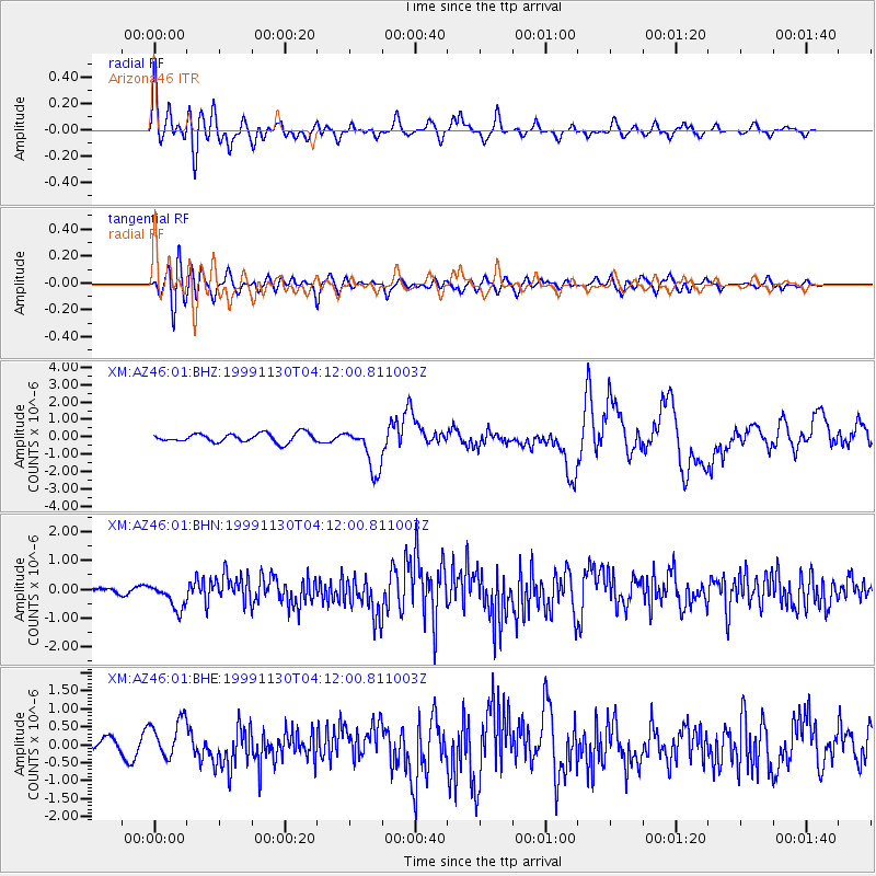
AZ46 Arizona46 - Earthquake Result Viewer

| Earthquake location: |
Northern Chile |
| Earthquake latitude/longitude: |
-18.9/-69.2 |
| Earthquake time(UTC): |
1999/11/30 (334) 04:01:53 GMT |
| Earthquake Depth: |
128 km |
| Earthquake Magnitude: |
6.2 MB, 6.6 MW, 6.5 MW |
| Earthquake Catalog/Contributor: |
WHDF/NEIC |
|
| Network: |
XM Rio Grande Seismic Transect |
| Station: |
AZ46 Arizona46 |
| Lat/Lon: |
36.55 N/109.23 W |
| Elevation: |
2009 m |
|
| Distance: |
66.9 deg |
| Az: |
325.705 deg |
| Baz: |
138.511 deg |
| Ray Param: |
0.05697046 |
| Estimated Moho Depth: |
23.75 km |
| Estimated Crust Vp/Vs: |
1.62 |
| Assumed Crust Vp: |
6.476 km/s |
| Estimated Crust Vs: |
3.991 km/s |
| Estimated Crust Poisson's Ratio: |
0.19 |
|
| Radial Match: |
86.106575 % |
| Radial Bump: |
400 |
| Transverse Match: |
73.23089 % |
| Transverse Bump: |
400 |
| SOD ConfigId: |
27569 |
| Insert Time: |
2010-02-26 17:20:54.306 +0000 |
| GWidth: |
2.5 |
| Max Bumps: |
400 |
| Tol: |
0.001 |
|
Signal To Noise
| Channel | StoN | STA | LTA |
| XM:AZ46:01:BHN:19991130T04:12:00.811003Z | 2.716944 | 4.45997E-7 | 1.641539E-7 |
| XM:AZ46:01:BHE:19991130T04:12:00.811003Z | 2.7712655 | 5.4284845E-7 | 1.958847E-7 |
| XM:AZ46:01:BHZ:19991130T04:12:00.811003Z | 5.044425 | 1.2833576E-6 | 2.5441108E-7 |
| Arrivals |
| Ps | 2.4 SECOND |
| PpPs | 9.2 SECOND |
| PsPs/PpSs | 12 SECOND |


