You are here: Home > Network List > XM99 - Rio Grande Seismic Transect Stations List
> Station AZ46 Arizona46 > Earthquake Result Viewer
AZ46 Arizona46 - Earthquake Result Viewer
| Earthquake location: |
Kodiak Island Region, Alaska |
| Earthquake latitude/longitude: |
57.4/-154.5 |
| Earthquake time(UTC): |
1999/12/06 (340) 23:12:33 GMT |
| Earthquake Depth: |
66 km |
| Earthquake Magnitude: |
6.8 MB, 7.0 MW, 7.0 ML |
| Earthquake Catalog/Contributor: |
WHDF/NEIC |
|
| Network: |
XM Rio Grande Seismic Transect |
| Station: |
AZ46 Arizona46 |
| Lat/Lon: |
36.55 N/109.23 W |
| Elevation: |
2009 m |
|
| Distance: |
36.4 deg |
| Az: |
105.234 deg |
| Baz: |
319.577 deg |
| Ray Param: |
0.07653771 |
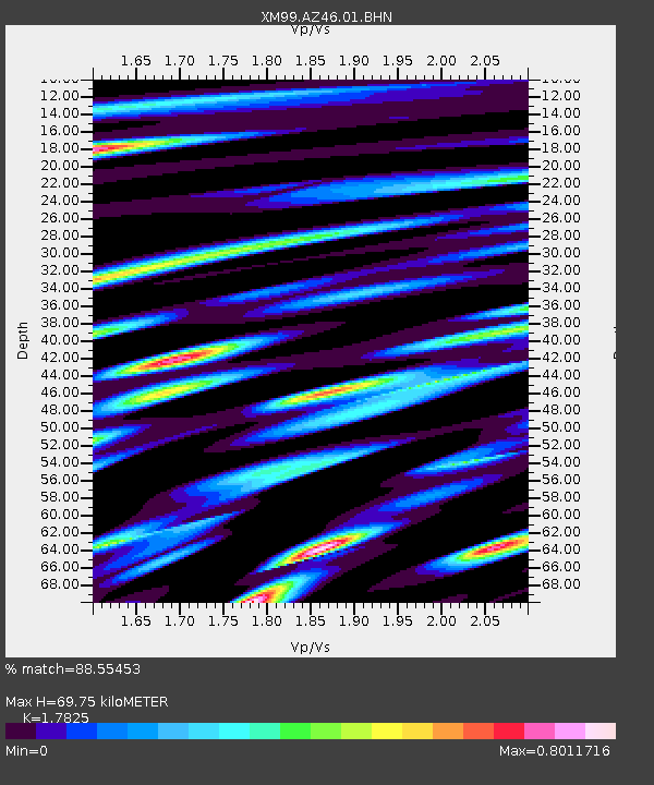
| Estimated Moho Depth: |
69.75 km |
| Estimated Crust Vp/Vs: |
1.78 |
| Assumed Crust Vp: |
6.476 km/s |
| Estimated Crust Vs: |
3.633 km/s |
| Estimated Crust Poisson's Ratio: |
0.27 |
|
| Radial Match: |
88.55453 % |
| Radial Bump: |
400 |
| Transverse Match: |
73.73311 % |
| Transverse Bump: |
400 |
| SOD ConfigId: |
27569 |
| Insert Time: |
2010-02-26 17:20:56.620 +0000 |
| GWidth: |
2.5 |
| Max Bumps: |
400 |
| Tol: |
0.001 |
|

Signal To Noise
| Channel | StoN | STA | LTA |
| XM:AZ46:01:BHN:19991206T23:19:01.297014Z | 6.7390785 | 1.3504686E-6 | 2.0039364E-7 |
| XM:AZ46:01:BHE:19991206T23:19:01.297014Z | 4.396652 | 1.0415756E-6 | 2.3690198E-7 |
| XM:AZ46:01:BHZ:19991206T23:19:01.297014Z | 14.008218 | 2.5547697E-6 | 1.823765E-7 |
| Arrivals |
| Ps | 9.1 SECOND |
| PpPs | 28 SECOND |
| PsPs/PpSs | 37 SECOND |


