You are here: Home > Network List > XM99 - Rio Grande Seismic Transect Stations List
> Station AZ45 Arizona54 > Earthquake Result Viewer
AZ45 Arizona54 - Earthquake Result Viewer
| Earthquake location: |
Tonga Islands |
| Earthquake latitude/longitude: |
-17.2/-173.9 |
| Earthquake time(UTC): |
2000/09/26 (270) 06:17:52 GMT |
| Earthquake Depth: |
56 km |
| Earthquake Magnitude: |
6.1 MB, 6.1 MS, 6.4 MW, 6.1 ME |
| Earthquake Catalog/Contributor: |
WHDF/NEIC |
|
| Network: |
XM Rio Grande Seismic Transect |
| Station: |
AZ45 Arizona54 |
| Lat/Lon: |
36.46 N/109.08 W |
| Elevation: |
2683 m |
|
| Distance: |
81.1 deg |
| Az: |
47.609 deg |
| Baz: |
241.131 deg |
| Ray Param: |
0.047687724 |
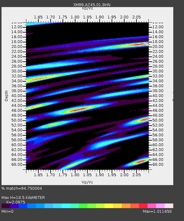
| Estimated Moho Depth: |
18.5 km |
| Estimated Crust Vp/Vs: |
2.10 |
| Assumed Crust Vp: |
6.476 km/s |
| Estimated Crust Vs: |
3.087 km/s |
| Estimated Crust Poisson's Ratio: |
0.35 |
|
| Radial Match: |
94.750084 % |
| Radial Bump: |
400 |
| Transverse Match: |
90.49257 % |
| Transverse Bump: |
400 |
| SOD ConfigId: |
16820 |
| Insert Time: |
2010-02-26 17:21:13.664 +0000 |
| GWidth: |
2.5 |
| Max Bumps: |
400 |
| Tol: |
0.001 |
|

Signal To Noise
| Channel | StoN | STA | LTA |
| XM:AZ45:01:BHN:20000926T06:29:30.823025Z | 3.7791095 | 3.4977293E-7 | 9.255433E-8 |
| XM:AZ45:01:BHE:20000926T06:29:30.823025Z | 5.7132006 | 4.5232338E-7 | 7.917163E-8 |
| XM:AZ45:01:BHZ:20000926T06:29:30.823025Z | 20.970608 | 1.8564253E-6 | 8.8525105E-8 |
| Arrivals |
| Ps | 3.2 SECOND |
| PpPs | 8.6 SECOND |
| PsPs/PpSs | 12 SECOND |


