
Station XM AZ45 - Arizona54
Network: XM99 - Rio Grande Seismic Transect
Nearby stations (2 deg radius)
| Station | Name | (Lat, Lon) | Start / End | Elevation |
| AZ45 | Arizona54 | (36.46, -109.08) | 1999-08-11 / 2001-12-31 | 2683 m |
| Crust2 Type: | Q6,orogen/41.5km no ice, cordilleras, 1.5 km seds. |
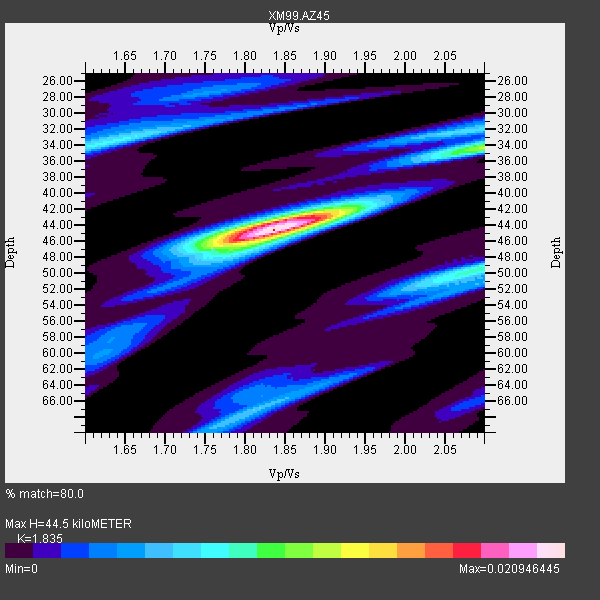
| Thickness Estimate: | 44 km |
| Thickness StdDev: | 1.7 km |
| Vp/Vs Estimate: | 1.84 |
| Vp/Vs StdDev: | 0.06 |
| Vs Estimate: | 3.529 km/s |
| Poisson's Ratio: | 0.29 |
| Peak Value: | 0.02 |
| Assumed Vp: | 6.476 km/s |
| Ps Weight: | 0.33333334 |
| PpPs Weight: | 0.33333334 |
| PsPs Weight: | 0.33333328 |
| Residual Complexity: | 0.586 |
| Nearby stations H: | +- |
| (2.0 deg) Vp/Vs: | +- |
12 with match > 90% ( 52.173912 %) and 23 with match > 80% ( 100.0 %) out of 23.
Download stack as xyz text file.
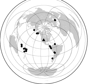
Azimuth Distribution of Events:
Prior Results for this Station
| Study | Thickness | Vp/Vs | Vp | Vs | Poissons Ratio | Extra |
| EARS | 44 km | 1.84 | 6.476 km/s | 3.529 km/s | 0.29 | |
| Crust2.0 | 42 km | 1.76 | 6.476 km/s | 3.675 km/s | 0.26 | Q6,orogen/41.5km no ice, cordilleras, 1.5 km seds. |
| Wilson | 47 km | 1.75 | 6.3 km/s | 3.6 km/s | 0.26 | |
| Global Maxima | 44 km | 1.84 | 6.476 km/s | 3.529 km/s | 0.29 | amp=0.020946445 |
| Local Maxima 1 | 34 km | 2.10 | 6.476 km/s | 3.087 km/s | 0.35 | amp=0.010779595 |
| Local Maxima 2 | 50 km | 2.09 | 6.476 km/s | 3.102 km/s | 0.35 | amp=0.008819212 |
| Local Maxima 3 | 34 km | 1.63 | 6.476 km/s | 3.979 km/s | 0.20 | amp=0.007866966 |
| Local Maxima 4 | 44 km | 1.84 | 6.476 km/s | 3.524 km/s | 0.29 | amp=0.007838436 |
| Predicted Arrivals for vertical incidence (zero ray parameter) | |
| Ps | 5.74 SECOND |
| PpPs | 19.48 SECOND |
| PsPs/PpSs | 25.22 SECOND |
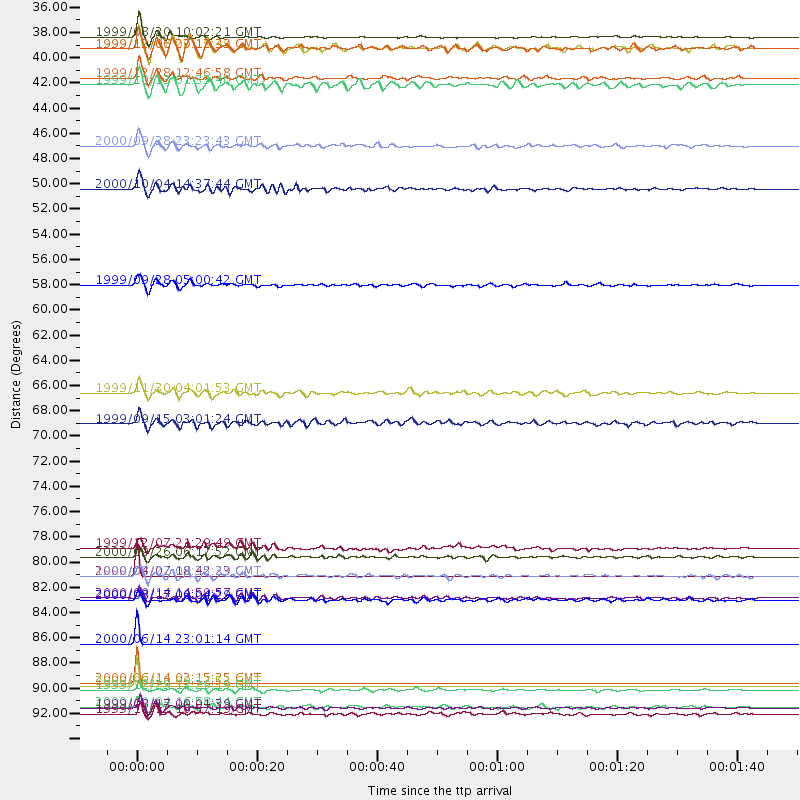
Events Processed for this Station
Download zip of receiver functions as SAC
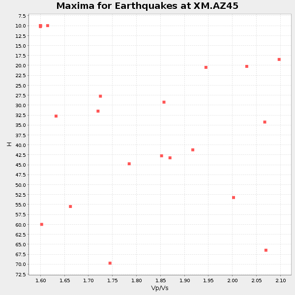
Plot maxima for each earthquake.
Events Used in the Stack
(23 events)| Radial Match | Distance | Baz | FERegion | Time | Lat/Lon | Depth | Magnitude |
| 99.997475 | 92.2 deg | 239.787 deg | South Of Fiji Islands | 2000/06/14 02:15:25 GMT | (-25.5, 178.0) | 605 km | 5.9 MB, 6.4 MW, 6.4 MW |
| 99.99703 | 88.8 deg | 246.734 deg | Fiji Islands Region | 2000/06/14 23:01:14 GMT | (-17.9, 176.2) | 33 km | 5.5 MB, 5.7 MS, 6.0 MW, 5.9 MW |
| 99.98378 | 92.5 deg | 257.703 deg | Santa Cruz Islands | 2000/06/10 09:17:53 GMT | (-11.4, 166.2) | 33 km | 5.4 MB, 5.6 MS, 5.9 MW, 5.9 MW |
| 99.9006 | 82.8 deg | 241.187 deg | Tonga Islands | 2000/04/07 18:42:23 GMT | (-18.3, -175.3) | 208 km | 5.4 MB, 5.8 MW, 5.8 MW |
| 95.711525 | 35.5 deg | 134.147 deg | Costa Rica | 1999/08/20 10:02:21 GMT | (9.0, -84.2) | 20 km | 6.1 MB, 6.9 MS, 7.0 MW, 6.1 ML |
| 95.64874 | 94.4 deg | 30.031 deg | Turkey | 1999/08/17 00:01:39 GMT | (40.7, 29.9) | 17 km | 6.3 MB, 7.8 MS, 7.7 ME, 7.6 MW |
| 94.750084 | 81.1 deg | 241.131 deg | Tonga Islands | 2000/09/26 06:17:52 GMT | (-17.2, -173.9) | 56 km | 6.1 MB, 6.1 MS, 6.4 MW, 6.1 ME |
| 93.531296 | 48.9 deg | 108.981 deg | Windward Islands | 2000/10/04 14:37:44 GMT | (11.1, -62.6) | 110 km | 5.6 MB, 5.4 MS, 6.1 MW, 5.9 MD |
| 92.31522 | 82.8 deg | 154.32 deg | Off Coast Of Southern Chile | 1999/08/22 09:35:39 GMT | (-40.5, -74.8) | 33 km | 6.2 MB, 5.8 MS, 6.4 MW, 6.2 MW |
| 90.67357 | 36.5 deg | 319.537 deg | Kodiak Island Region, Alaska | 1999/12/07 00:19:49 GMT | (57.4, -154.5) | 41 km | 6.5 MB, 6.1 MS, 6.4 MW, 6.3 ML |
| 90.22169 | 45.1 deg | 137.62 deg | Near Coast Of Ecuador | 2000/09/28 23:23:43 GMT | (-0.2, -80.6) | 23 km | 5.8 MB, 6.0 MS, 6.6 MW, 6.4 MW |
| 90.19129 | 84.7 deg | 246.205 deg | Fiji Islands | 2000/09/14 14:59:57 GMT | (-15.7, 179.8) | 33 km | 5.7 MB, 6.2 MS, 6.3 MW, 6.2 MW |
| 89.98537 | 36.5 deg | 319.626 deg | Kodiak Island Region, Alaska | 1999/12/06 23:12:33 GMT | (57.4, -154.5) | 66 km | 6.8 MB, 7.0 MW, 7.0 ML |
| 89.79687 | 57.2 deg | 316.655 deg | Komandorskiye Ostrova Region | 1999/09/28 05:00:42 GMT | (54.6, 168.3) | 33 km | 5.4 MB, 6.1 MS, 6.1 MW, 6.1 MW |
| 88.02648 | 84.9 deg | 238.179 deg | Tonga Islands | 2000/08/17 00:04:29 GMT | (-21.9, -174.8) | 33 km | 5.4 MB, 5.8 MS, 5.9 MW, 5.7 MW |
| 86.561714 | 39.1 deg | 135.375 deg | South Of Panama | 1999/12/28 12:46:58 GMT | (5.6, -82.6) | 10 km | 5.4 MB, 5.5 MS, 5.9 MW, 5.5 ML |
| 85.858086 | 39.7 deg | 314.143 deg | Alaska Peninsula | 1999/10/13 01:33:40 GMT | (54.7, -161.2) | 30 km | 6.0 MB, 6.2 MS, 6.5 MW, 6.0 ML |
| 84.832596 | 66.7 deg | 138.609 deg | Northern Chile | 1999/11/30 04:01:53 GMT | (-18.9, -69.2) | 128 km | 6.2 MB, 6.6 MW, 6.5 MW |
| 84.61463 | 69.4 deg | 138.267 deg | Southern Bolivia | 1999/09/15 03:01:24 GMT | (-20.9, -67.3) | 218 km | 6.0 MB, 6.4 MW, 6.4 MW |
| 83.85574 | 94.9 deg | 29.184 deg | Turkey | 1999/11/12 16:57:19 GMT | (40.8, 31.2) | 10 km | 6.3 MB, 7.5 MS, 7.2 MW, 6.6 ML |
| 81.07891 | 92.8 deg | 258.69 deg | Santa Cruz Islands | 1999/12/29 13:29:19 GMT | (-10.9, 165.4) | 33 km | 5.6 MB, 6.8 MS, 6.8 MW, 6.3 MW |
| 80.26988 | 80.3 deg | 242.112 deg | Tonga Islands | 1999/12/07 21:29:49 GMT | (-15.9, -174.0) | 138 km | 6.2 MB, 6.4 MW, 6.4 MW |
| 80.14282 | 94.3 deg | 254.134 deg | Vanuatu Islands | 2000/10/04 16:58:44 GMT | (-15.4, 166.9) | 23 km | 6.1 MB, 6.9 MS, 6.8 MW, 6.5 ME |
Losers
(0 events)| Radial Match | Distance | Baz | FERegion | Time | Lat/Lon | Depth | Magnitude | Reason |
