You are here: Home > Network List > XM99 - Rio Grande Seismic Transect Stations List
> Station AZ45 Arizona54 > Earthquake Result Viewer
AZ45 Arizona54 - Earthquake Result Viewer

| Earthquake location: |
Alaska Peninsula |
| Earthquake latitude/longitude: |
54.7/-161.2 |
| Earthquake time(UTC): |
1999/10/13 (286) 01:33:40 GMT |
| Earthquake Depth: |
30 km |
| Earthquake Magnitude: |
6.0 MB, 6.2 MS, 6.5 MW, 6.0 ML |
| Earthquake Catalog/Contributor: |
WHDF/NEIC |
|
| Network: |
XM Rio Grande Seismic Transect |
| Station: |
AZ45 Arizona54 |
| Lat/Lon: |
36.46 N/109.08 W |
| Elevation: |
2683 m |
|
| Distance: |
39.7 deg |
| Az: |
95.32 deg |
| Baz: |
314.143 deg |
| Ray Param: |
0.074767016 |
| Estimated Moho Depth: |
43.25 km |
| Estimated Crust Vp/Vs: |
1.87 |
| Assumed Crust Vp: |
6.476 km/s |
| Estimated Crust Vs: |
3.463 km/s |
| Estimated Crust Poisson's Ratio: |
0.30 |
|
| Radial Match: |
85.858086 % |
| Radial Bump: |
400 |
| Transverse Match: |
79.23895 % |
| Transverse Bump: |
400 |
| SOD ConfigId: |
27569 |
| Insert Time: |
2010-02-26 17:21:22.013 +0000 |
| GWidth: |
2.5 |
| Max Bumps: |
400 |
| Tol: |
0.001 |
|
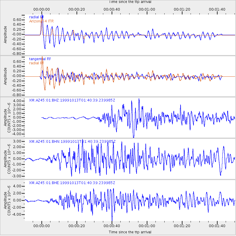
Signal To Noise
| Channel | StoN | STA | LTA |
| XM:AZ45:01:BHN:19991013T01:40:39.239985Z | 1.199689 | 1.6543464E-7 | 1.3789794E-7 |
| XM:AZ45:01:BHE:19991013T01:40:39.239985Z | 1.1755767 | 1.8372407E-7 | 1.562842E-7 |
| XM:AZ45:01:BHZ:19991013T01:40:39.239985Z | 2.8725793 | 3.6638815E-7 | 1.2754674E-7 |
| Arrivals |
| Ps | 6.2 SECOND |
| PpPs | 18 SECOND |
| PsPs/PpSs | 24 SECOND |


