You are here: Home > Network List > XM99 - Rio Grande Seismic Transect Stations List
> Station AZ45 Arizona54 > Earthquake Result Viewer
AZ45 Arizona54 - Earthquake Result Viewer
| Earthquake location: |
Tonga Islands |
| Earthquake latitude/longitude: |
-15.9/-174.0 |
| Earthquake time(UTC): |
1999/12/07 (341) 21:29:49 GMT |
| Earthquake Depth: |
138 km |
| Earthquake Magnitude: |
6.2 MB, 6.4 MW, 6.4 MW |
| Earthquake Catalog/Contributor: |
WHDF/NEIC |
|
| Network: |
XM Rio Grande Seismic Transect |
| Station: |
AZ45 Arizona54 |
| Lat/Lon: |
36.46 N/109.08 W |
| Elevation: |
2683 m |
|
| Distance: |
80.3 deg |
| Az: |
47.783 deg |
| Baz: |
242.112 deg |
| Ray Param: |
0.04802686 |
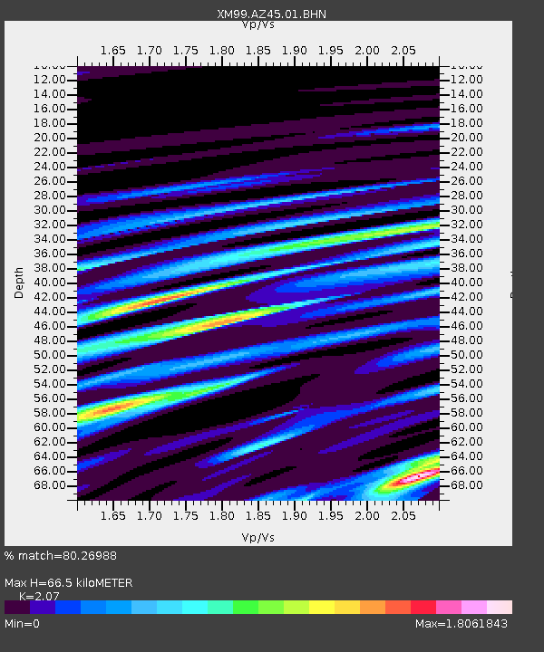
| Estimated Moho Depth: |
66.5 km |
| Estimated Crust Vp/Vs: |
2.07 |
| Assumed Crust Vp: |
6.476 km/s |
| Estimated Crust Vs: |
3.128 km/s |
| Estimated Crust Poisson's Ratio: |
0.35 |
|
| Radial Match: |
80.26988 % |
| Radial Bump: |
400 |
| Transverse Match: |
79.4337 % |
| Transverse Bump: |
400 |
| SOD ConfigId: |
27569 |
| Insert Time: |
2010-02-26 17:21:32.882 +0000 |
| GWidth: |
2.5 |
| Max Bumps: |
400 |
| Tol: |
0.001 |
|

Signal To Noise
| Channel | StoN | STA | LTA |
| XM:AZ45:01:BHN:19991207T21:41:14.074016Z | 3.6280692 | 1.0974651E-6 | 3.0249288E-7 |
| XM:AZ45:01:BHE:19991207T21:41:14.074016Z | 4.790306 | 1.182742E-6 | 2.469032E-7 |
| XM:AZ45:01:BHZ:19991207T21:41:14.074016Z | 20.93002 | 3.9774327E-6 | 1.9003484E-7 |
| Arrivals |
| Ps | 11 SECOND |
| PpPs | 31 SECOND |
| PsPs/PpSs | 42 SECOND |


