You are here: Home > Network List > XM99 - Rio Grande Seismic Transect Stations List
> Station NM10 NewMexico10 > Earthquake Result Viewer
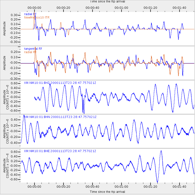
NM10 NewMexico10 - Earthquake Result Viewer

| Earthquake location: |
Fiji Islands Region |
| Earthquake latitude/longitude: |
-21.3/-179.2 |
| Earthquake time(UTC): |
2000/11/13 (318) 23:17:28 GMT |
| Earthquake Depth: |
628 km |
| Earthquake Magnitude: |
5.1 MB, 5.6 MW |
| Earthquake Catalog/Contributor: |
WHDF/NEIC |
|
| Network: |
XM Rio Grande Seismic Transect |
| Station: |
NM10 NewMexico10 |
| Lat/Lon: |
32.47 N/104.27 W |
| Elevation: |
929 m |
|
| Distance: |
89.3 deg |
| Az: |
54.726 deg |
| Baz: |
244.275 deg |
| Ray Param: |
0.04155615 |
| Estimated Moho Depth: |
22.0 km |
| Estimated Crust Vp/Vs: |
2.09 |
| Assumed Crust Vp: |
6.232 km/s |
| Estimated Crust Vs: |
2.985 km/s |
| Estimated Crust Poisson's Ratio: |
0.35 |
|
| Radial Match: |
80.95059 % |
| Radial Bump: |
382 |
| Transverse Match: |
59.46821 % |
| Transverse Bump: |
400 |
| SOD ConfigId: |
16820 |
| Insert Time: |
2010-02-26 17:21:35.815 +0000 |
| GWidth: |
2.5 |
| Max Bumps: |
400 |
| Tol: |
0.001 |
|
Signal To Noise
| Channel | StoN | STA | LTA |
| XM:NM10:01:BHN:20001113T23:28:47.757021Z | 1.2080282 | 2.2982498E-7 | 1.9024803E-7 |
| XM:NM10:01:BHE:20001113T23:28:47.757021Z | 0.9055512 | 1.5436797E-7 | 1.7046852E-7 |
| XM:NM10:01:BHZ:20001113T23:28:47.757021Z | 1.1421503 | 3.6836641E-7 | 3.225201E-7 |
| Arrivals |
| Ps | 3.9 SECOND |
| PpPs | 11 SECOND |
| PsPs/PpSs | 15 SECOND |


