
Station XM NM10 - NewMexico10
Network: XM99 - Rio Grande Seismic Transect
Nearby stations (2 deg radius)
| Station | Name | (Lat, Lon) | Start / End | Elevation |
| NM10 | NewMexico10 | (32.47, -104.27) | 1999-09-12 / 2001-12-31 | 929 m |
| Crust2 Type: | P2,orogen/38km, Alps and Foreland, 2 km seds. |
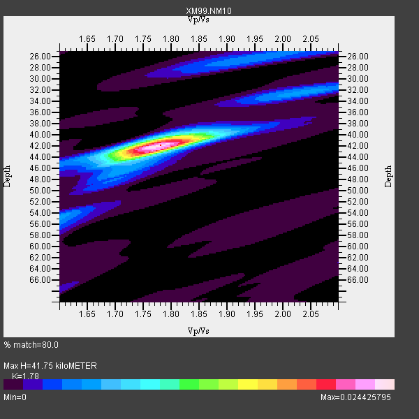
| Thickness Estimate: | 42 km |
| Thickness StdDev: | 0.4 km |
| Vp/Vs Estimate: | 1.78 |
| Vp/Vs StdDev: | 0.02 |
| Vs Estimate: | 3.501 km/s |
| Poisson's Ratio: | 0.27 |
| Peak Value: | 0.02 |
| Assumed Vp: | 6.232 km/s |
| Ps Weight: | 0.33333334 |
| PpPs Weight: | 0.33333334 |
| PsPs Weight: | 0.33333328 |
| Residual Complexity: | 0.341 |
| Nearby stations H: | +- |
| (2.0 deg) Vp/Vs: | +- |
7 with match > 90% ( 38.88889 %) and 18 with match > 80% ( 100.0 %) out of 18.
Download stack as xyz text file.
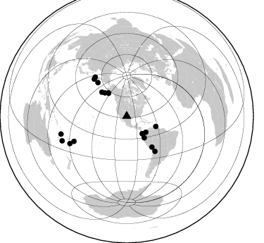
Azimuth Distribution of Events:
Prior Results for this Station
| Study | Thickness | Vp/Vs | Vp | Vs | Poissons Ratio | Extra |
| EARS | 42 km | 1.78 | 6.232 km/s | 3.501 km/s | 0.27 | |
| Crust2.0 | 38 km | 1.76 | 6.232 km/s | 3.534 km/s | 0.26 | P2,orogen/38km, Alps and Foreland, 2 km seds. |
| Wilson | 41 km | 1.74 | 6.21 km/s | 3.569 km/s | 0.25 | |
| Global Maxima | 42 km | 1.78 | 6.232 km/s | 3.501 km/s | 0.27 | amp=0.024425795 |
| Local Maxima 1 | 44 km | 1.74 | 6.232 km/s | 3.581 km/s | 0.25 | amp=0.009432187 |
| Local Maxima 2 | 40 km | 1.80 | 6.232 km/s | 3.457 km/s | 0.28 | amp=0.0062503377 |
| Local Maxima 3 | 26 km | 1.95 | 6.232 km/s | 3.192 km/s | 0.32 | amp=0.004738926 |
| Local Maxima 4 | 55 km | 1.60 | 6.232 km/s | 3.895 km/s | 0.18 | amp=0.0043353806 |
| Predicted Arrivals for vertical incidence (zero ray parameter) | |
| Ps | 5.23 SECOND |
| PpPs | 18.63 SECOND |
| PsPs/PpSs | 23.85 SECOND |
Events Processed for this Station
Download zip of receiver functions as SAC
Plot maxima for each earthquake.
Events Used in the Stack
(18 events)| Radial Match | Distance | Baz | FERegion | Time | Lat/Lon | Depth | Magnitude |
| 98.40562 | 42.1 deg | 321.658 deg | Kodiak Island Region, Alaska | 1999/12/06 23:12:33 GMT | (57.4, -154.5) | 66 km | 6.8 MB, 7.0 MW, 7.0 ML |
| 97.29742 | 98.0 deg | 249.136 deg | Southeast Of Loyalty Islands | 2001/02/28 13:05:31 GMT | (-22.0, 170.1) | 10 km | 5.8 MB, 6.1 MS, 6.2 MW |
| 94.99482 | 39.5 deg | 140.796 deg | Near Coast Of Ecuador | 2000/09/28 23:23:43 GMT | (-0.2, -80.6) | 23 km | 5.8 MB, 6.0 MS, 6.6 MW, 6.4 MW |
| 94.762054 | 82.9 deg | 244.597 deg | Tonga Islands | 2000/09/26 06:17:52 GMT | (-17.2, -173.9) | 56 km | 6.1 MB, 6.1 MS, 6.4 MW, 6.1 ME |
| 93.14945 | 96.6 deg | 254.844 deg | Vanuatu Islands | 1999/11/26 13:21:15 GMT | (-16.4, 168.2) | 33 km | 6.4 MB, 7.3 MS, 7.5 MW, 7.3 MW |
| 93.001656 | 43.8 deg | 109.363 deg | Windward Islands | 2000/10/04 14:37:44 GMT | (11.1, -62.6) | 110 km | 5.6 MB, 5.4 MS, 6.1 MW, 5.9 MD |
| 90.23874 | 41.3 deg | 321.435 deg | Kodiak Island Region, Alaska | 2001/01/10 16:02:44 GMT | (57.1, -153.2) | 33 km | 6.2 MB, 6.8 MS, 7.1 MW, 6.8 ML |
| 88.10948 | 45.3 deg | 316.8 deg | Alaska Peninsula | 1999/10/13 01:33:40 GMT | (54.7, -161.2) | 30 km | 6.0 MB, 6.2 MS, 6.5 MW, 6.0 ML |
| 87.133804 | 35.3 deg | 130.086 deg | Panama-Colombia Border Region | 2000/11/08 06:59:58 GMT | (7.0, -77.8) | 17 km | 6.0 MB, 6.4 MS, 6.5 MW, 6.2 ML |
| 85.9176 | 62.9 deg | 319.201 deg | Komandorskiye Ostrova Region | 1999/09/28 05:00:42 GMT | (54.6, 168.3) | 33 km | 5.4 MB, 6.1 MS, 6.1 MW, 6.1 MW |
| 85.114586 | 63.8 deg | 141.185 deg | Southern Bolivia | 1999/09/15 03:01:24 GMT | (-20.9, -67.3) | 218 km | 6.0 MB, 6.4 MW, 6.4 MW |
| 85.05858 | 33.1 deg | 137.983 deg | South Of Panama | 2000/12/12 05:26:45 GMT | (6.0, -82.7) | 10 km | 5.8 MB, 5.7 MS, 6.3 ME, 6.1 MW |
| 83.76359 | 49.2 deg | 313.823 deg | Fox Islands, Aleutian Islands | 2000/12/05 22:11:34 GMT | (52.6, -167.8) | 33 km | 5.6 MB, 5.6 MS, 5.9 MW, 5.4 ML |
| 83.207 | 33.5 deg | 138.348 deg | South Of Panama | 1999/12/28 12:46:58 GMT | (5.6, -82.6) | 10 km | 5.4 MB, 5.5 MS, 5.9 MW, 5.5 ML |
| 81.584564 | 70.1 deg | 318.544 deg | Near East Coast Of Kamchatka | 1999/09/18 21:28:33 GMT | (51.2, 157.6) | 60 km | 5.9 MB, 5.6 MS, 6.2 MW, 6.0 MW |
| 81.37792 | 71.4 deg | 321.134 deg | Northwest Of Kuril Islands | 2001/02/07 15:16:15 GMT | (52.8, 153.8) | 427 km | 5.6 MB, 5.8 MW, 5.7 MW |
| 81.0372 | 56.4 deg | 140.736 deg | Central Peru | 1999/11/27 02:31:49 GMT | (-14.5, -71.3) | 126 km | 5.8 MB, 5.9 MW, 5.9 MW |
| 80.95059 | 89.3 deg | 244.275 deg | Fiji Islands Region | 2000/11/13 23:17:28 GMT | (-21.3, -179.2) | 628 km | 5.1 MB, 5.6 MW |
Losers
(0 events)| Radial Match | Distance | Baz | FERegion | Time | Lat/Lon | Depth | Magnitude | Reason |
