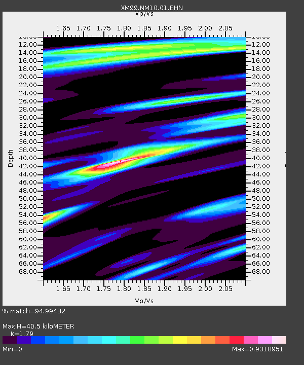
NM10 NewMexico10 - Earthquake Result Viewer
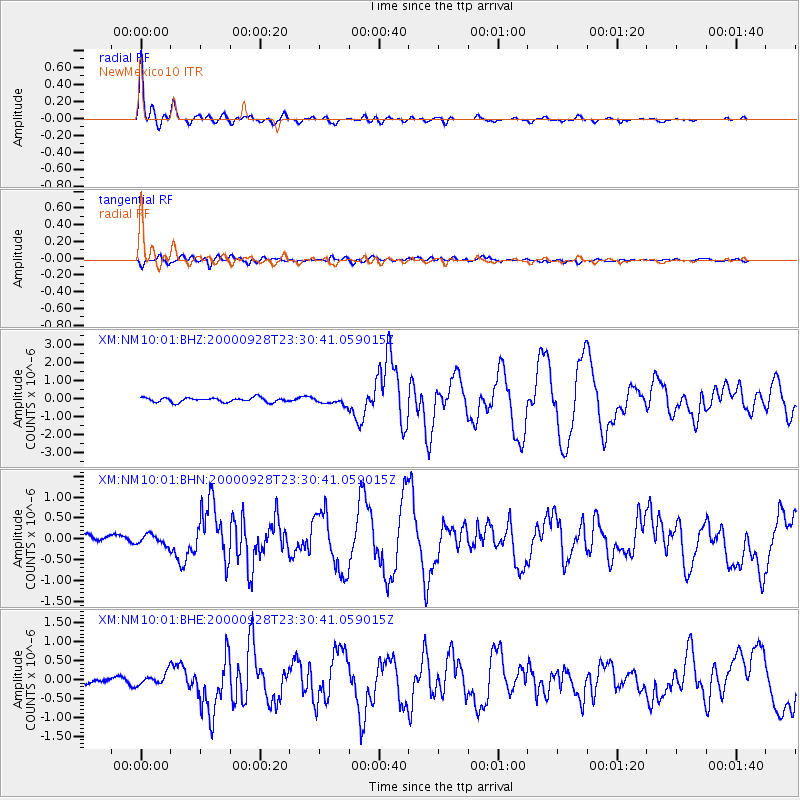
Earthquake location: Near Coast Of Ecuador
Earthquake latitude/longitude: -0.2/-80.6
Earthquake time(UTC): 2000/09/28 (272) 23:23:43 GMT
Earthquake Depth: 23 km
Earthquake Magnitude: 5.8 MB, 6.0 MS, 6.6 MW, 6.4 MW
Earthquake Catalog/Contributor: WHDF/NEIC
Network: XM Rio Grande Seismic Transect
Station: NM10 NewMexico10
Lat/Lon: 32.47 N/104.27 W
Elevation: 929 m
Distance: 39.5 deg
Az: 327.704 deg
Baz: 140.796 deg
Ray Param: 0.07493822
Estimated Moho Depth: 40.5 km
Estimated Crust Vp/Vs: 1.79
Assumed Crust Vp: 6.232 km/s
Estimated Crust Vs: 3.481 km/s
Estimated Crust Poisson's Ratio: 0.27
Radial Match: 94.99482 %
Radial Bump: 317
Transverse Match: 85.99044 %
Transverse Bump: 400
SOD ConfigId: 27569
Insert Time: 2010-02-26 17:21:38.035 +0000
GWidth: 2.5
Max Bumps: 400
Tol: 0.001

Signal To Noise

ChannelStoNSTALTA
XM:NM10:01:BHN:20000928T23:30:41.059015Z1.1784021.250166E-71.0608994E-7
XM:NM10:01:BHE:20000928T23:30:41.059015Z1.59943311.6202723E-71.01302916E-7
XM:NM10:01:BHZ:20000928T23:30:41.059015Z1.69371192.0574758E-71.2147731E-7
Arrivals
Ps5.5 SECOND
PpPs17 SECOND
PsPs/PpSs22 SECOND