NM10 NewMexico10 - Earthquake Result Viewer
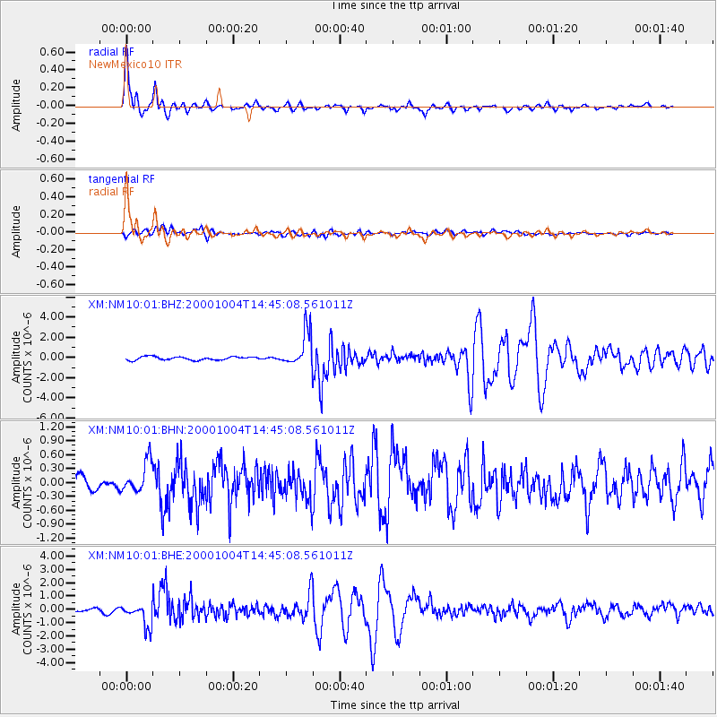
Earthquake location: Windward Islands
Earthquake latitude/longitude: 11.1/-62.6
Earthquake time(UTC): 2000/10/04 (278) 14:37:44 GMT
Earthquake Depth: 110 km
Earthquake Magnitude: 5.6 MB, 5.4 MS, 6.1 MW, 5.9 MD
Earthquake Catalog/Contributor: WHDF/NEIC
Network: XM Rio Grande Seismic Transect
Station: NM10 NewMexico10
Lat/Lon: 32.47 N/104.27 W
Elevation: 929 m
Distance: 43.8 deg
Az: 305.656 deg
Baz: 109.363 deg
Ray Param: 0.07193472
Estimated Moho Depth: 33.25 km
Estimated Crust Vp/Vs: 1.96
Assumed Crust Vp: 6.232 km/s
Estimated Crust Vs: 3.183 km/s
Estimated Crust Poisson's Ratio: 0.32
Radial Match: 93.001656 %
Radial Bump: 400
Transverse Match: 78.59989 %
Transverse Bump: 400
SOD ConfigId: 16820
Insert Time: 2010-02-26 17:21:42.141 +0000
GWidth: 2.5
Max Bumps: 400
Tol: 0.001

Signal To Noise

ChannelStoNSTALTA
XM:NM10:01:BHN:20001004T14:45:08.561011Z2.59811043.5411463E-71.36297E-7
XM:NM10:01:BHE:20001004T14:45:08.561011Z7.72097548.642192E-71.1193135E-7
XM:NM10:01:BHZ:20001004T14:45:08.561011Z10.4053091.7468755E-61.678831E-7
Arrivals
Ps5.4 SECOND
PpPs15 SECOND
PsPs/PpSs20 SECOND