You are here: Home > Network List > XM99 - Rio Grande Seismic Transect Stations List
> Station NM10 NewMexico10 > Earthquake Result Viewer
NM10 NewMexico10 - Earthquake Result Viewer
| Earthquake location: |
Southeast Of Loyalty Islands |
| Earthquake latitude/longitude: |
-22.0/170.1 |
| Earthquake time(UTC): |
2001/02/28 (059) 13:05:31 GMT |
| Earthquake Depth: |
10 km |
| Earthquake Magnitude: |
5.8 MB, 6.1 MS, 6.2 MW |
| Earthquake Catalog/Contributor: |
WHDF/NEIC |
|
| Network: |
XM Rio Grande Seismic Transect |
| Station: |
NM10 NewMexico10 |
| Lat/Lon: |
32.47 N/104.27 W |
| Elevation: |
929 m |
|
| Distance: |
98.0 deg |
| Az: |
58.331 deg |
| Baz: |
249.136 deg |
| Ray Param: |
0.040040474 |
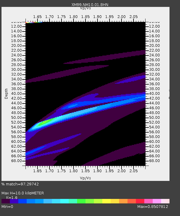
| Estimated Moho Depth: |
10.0 km |
| Estimated Crust Vp/Vs: |
1.60 |
| Assumed Crust Vp: |
6.232 km/s |
| Estimated Crust Vs: |
3.895 km/s |
| Estimated Crust Poisson's Ratio: |
0.18 |
|
| Radial Match: |
97.29742 % |
| Radial Bump: |
400 |
| Transverse Match: |
87.96015 % |
| Transverse Bump: |
400 |
| SOD ConfigId: |
3744 |
| Insert Time: |
2010-02-26 17:21:46.570 +0000 |
| GWidth: |
2.5 |
| Max Bumps: |
400 |
| Tol: |
0.001 |
|
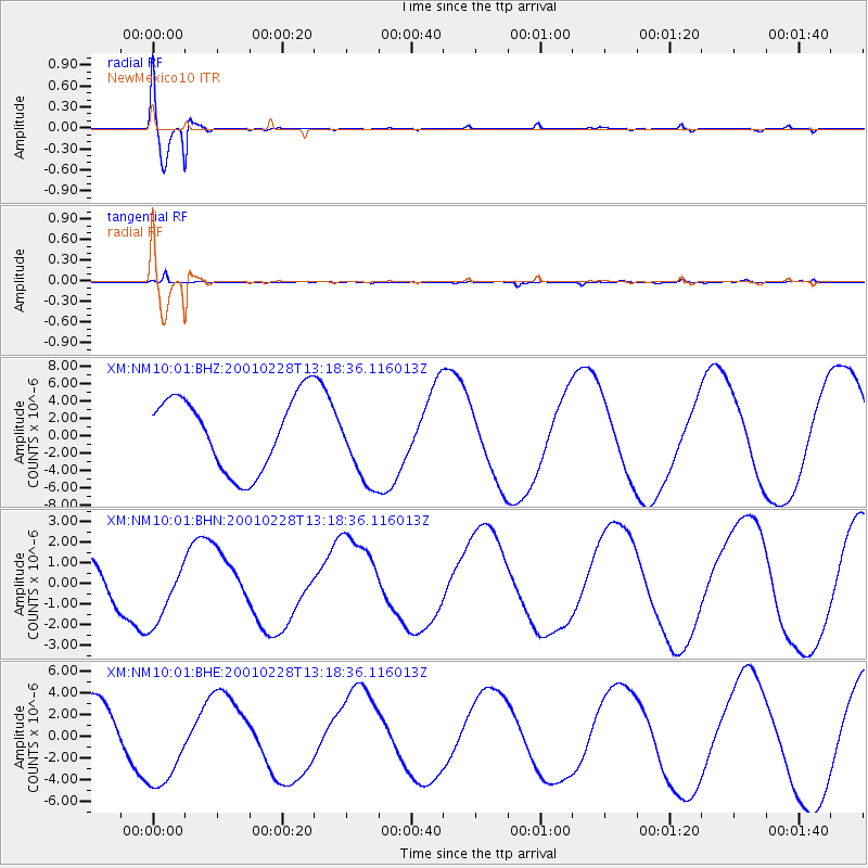
Signal To Noise
| Channel | StoN | STA | LTA |
| XM:NM10:01:BHN:20010228T13:18:36.116013Z | 1.620829 | 1.698039E-6 | 1.0476361E-6 |
| XM:NM10:01:BHE:20010228T13:18:36.116013Z | 1.8151443 | 4.454108E-6 | 2.453859E-6 |
| XM:NM10:01:BHZ:20010228T13:18:36.116013Z | 1.121445 | 4.774882E-6 | 4.2577944E-6 |
| Arrivals |
| Ps | 1.0 SECOND |
| PpPs | 4.1 SECOND |
| PsPs/PpSs | 5.1 SECOND |


