You are here: Home > Network List > XM99 - Rio Grande Seismic Transect Stations List
> Station NM10 NewMexico10 > Earthquake Result Viewer
NM10 NewMexico10 - Earthquake Result Viewer
| Earthquake location: |
Northwest Of Kuril Islands |
| Earthquake latitude/longitude: |
52.8/153.8 |
| Earthquake time(UTC): |
2001/02/07 (038) 15:16:15 GMT |
| Earthquake Depth: |
427 km |
| Earthquake Magnitude: |
5.6 MB, 5.8 MW, 5.7 MW |
| Earthquake Catalog/Contributor: |
WHDF/NEIC |
|
| Network: |
XM Rio Grande Seismic Transect |
| Station: |
NM10 NewMexico10 |
| Lat/Lon: |
32.47 N/104.27 W |
| Elevation: |
929 m |
|
| Distance: |
71.4 deg |
| Az: |
60.761 deg |
| Baz: |
321.134 deg |
| Ray Param: |
0.05300518 |
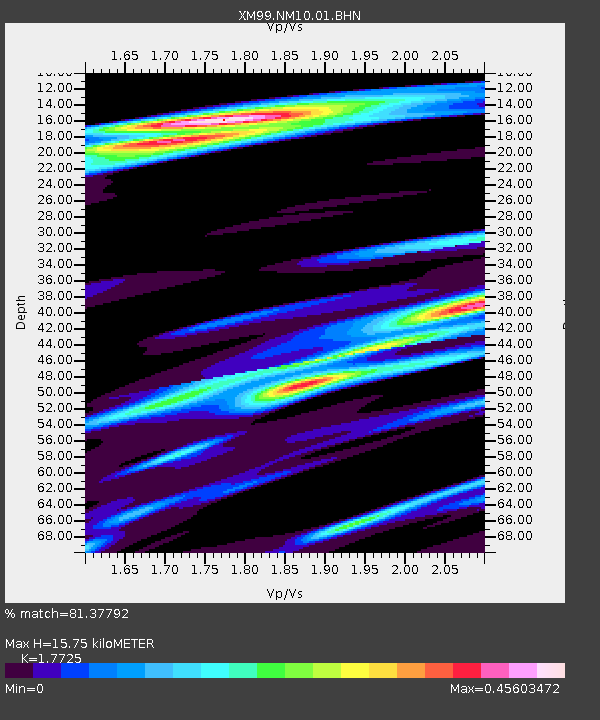
| Estimated Moho Depth: |
15.75 km |
| Estimated Crust Vp/Vs: |
1.77 |
| Assumed Crust Vp: |
6.232 km/s |
| Estimated Crust Vs: |
3.516 km/s |
| Estimated Crust Poisson's Ratio: |
0.27 |
|
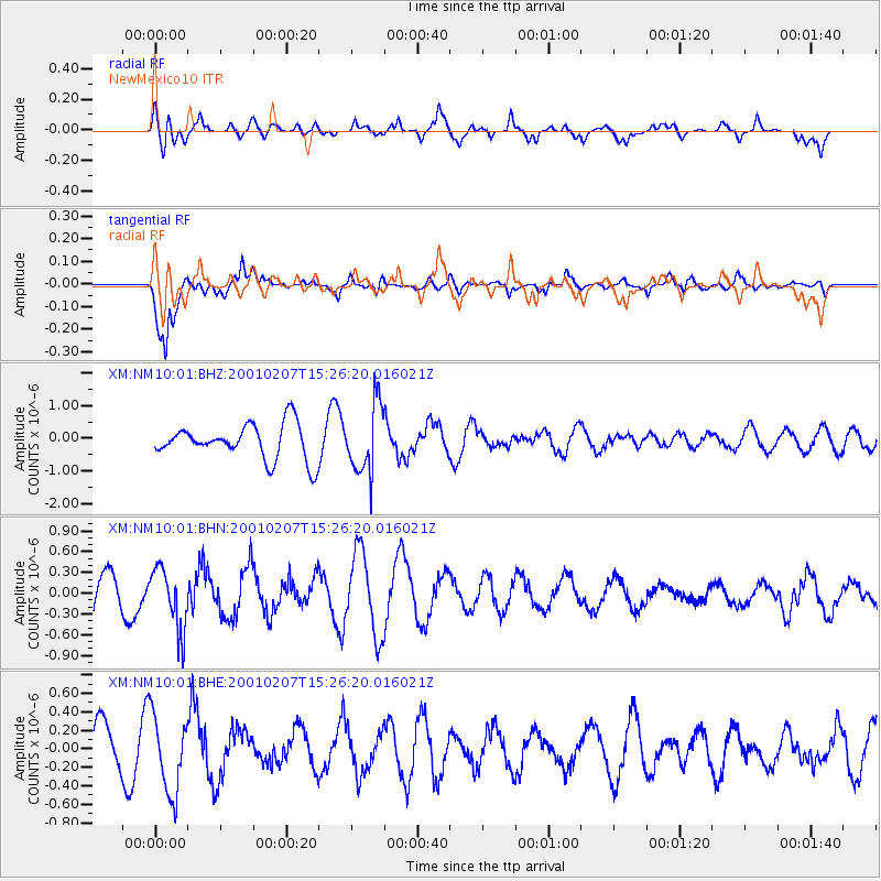
| Radial Match: |
81.37792 % |
| Radial Bump: |
400 |
| Transverse Match: |
86.95754 % |
| Transverse Bump: |
400 |
| SOD ConfigId: |
3753 |
| Insert Time: |
2010-02-26 17:21:47.707 +0000 |
| GWidth: |
2.5 |
| Max Bumps: |
400 |
| Tol: |
0.001 |
|
Signal To Noise
| Channel | StoN | STA | LTA |
| XM:NM10:01:BHN:20010207T15:26:20.016021Z | 2.0662823 | 4.422816E-7 | 2.1404703E-7 |
| XM:NM10:01:BHE:20010207T15:26:20.016021Z | 1.7609289 | 4.1361218E-7 | 2.3488296E-7 |
| XM:NM10:01:BHZ:20010207T15:26:20.016021Z | 1.9551908 | 1.0524236E-6 | 5.382716E-7 |
| Arrivals |
| Ps | 2.0 SECOND |
| PpPs | 6.8 SECOND |
| PsPs/PpSs | 8.8 SECOND |


