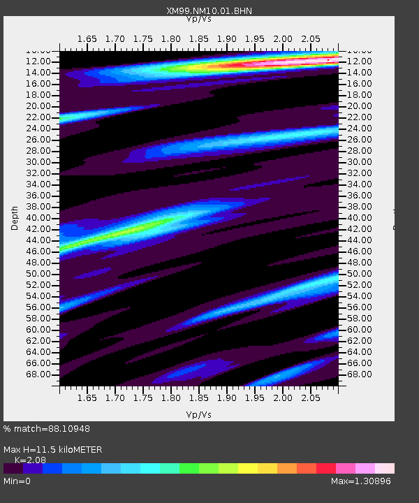
NM10 NewMexico10 - Earthquake Result Viewer
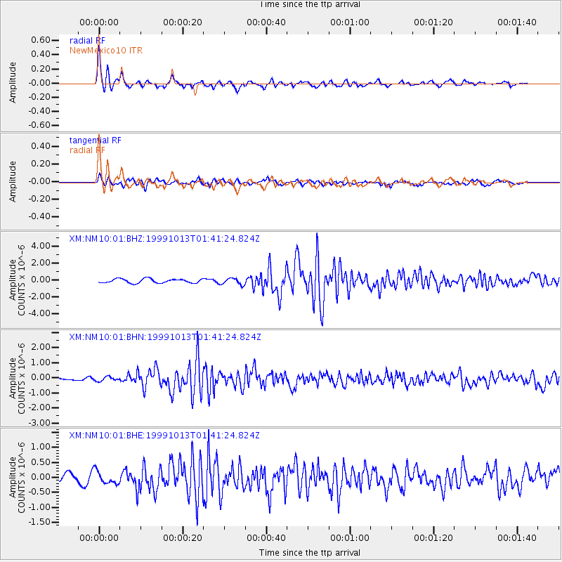
Earthquake location: Alaska Peninsula
Earthquake latitude/longitude: 54.7/-161.2
Earthquake time(UTC): 1999/10/13 (286) 01:33:40 GMT
Earthquake Depth: 30 km
Earthquake Magnitude: 6.0 MB, 6.2 MS, 6.5 MW, 6.0 ML
Earthquake Catalog/Contributor: WHDF/NEIC
Network: XM Rio Grande Seismic Transect
Station: NM10 NewMexico10
Lat/Lon: 32.47 N/104.27 W
Elevation: 929 m
Distance: 45.3 deg
Az: 95.242 deg
Baz: 316.8 deg
Ray Param: 0.071286514
Estimated Moho Depth: 11.5 km
Estimated Crust Vp/Vs: 2.08
Assumed Crust Vp: 6.232 km/s
Estimated Crust Vs: 2.996 km/s
Estimated Crust Poisson's Ratio: 0.35
Radial Match: 88.10948 %
Radial Bump: 400
Transverse Match: 75.26544 %
Transverse Bump: 400
SOD ConfigId: 27569
Insert Time: 2010-02-26 17:21:48.815 +0000
GWidth: 2.5
Max Bumps: 400
Tol: 0.001

Signal To Noise

ChannelStoNSTALTA
XM:NM10:01:BHN:19991013T01:41:24.824Z1.55842851.4372876E-79.222672E-8
XM:NM10:01:BHE:19991013T01:41:24.824Z1.92754171.9356912E-71.00422795E-7
XM:NM10:01:BHZ:19991013T01:41:24.824Z1.58964473.8329543E-72.411202E-7
Arrivals
Ps2.1 SECOND
PpPs5.4 SECOND
PsPs/PpSs7.5 SECOND