You are here: Home > Network List > XM99 - Rio Grande Seismic Transect Stations List
> Station NM10 NewMexico10 > Earthquake Result Viewer
NM10 NewMexico10 - Earthquake Result Viewer
| Earthquake location: |
Central Peru |
| Earthquake latitude/longitude: |
-14.5/-71.3 |
| Earthquake time(UTC): |
1999/11/27 (331) 02:31:49 GMT |
| Earthquake Depth: |
126 km |
| Earthquake Magnitude: |
5.8 MB, 5.9 MW, 5.9 MW |
| Earthquake Catalog/Contributor: |
WHDF/NEIC |
|
| Network: |
XM Rio Grande Seismic Transect |
| Station: |
NM10 NewMexico10 |
| Lat/Lon: |
32.47 N/104.27 W |
| Elevation: |
929 m |
|
| Distance: |
56.4 deg |
| Az: |
326.467 deg |
| Baz: |
140.736 deg |
| Ray Param: |
0.06377536 |
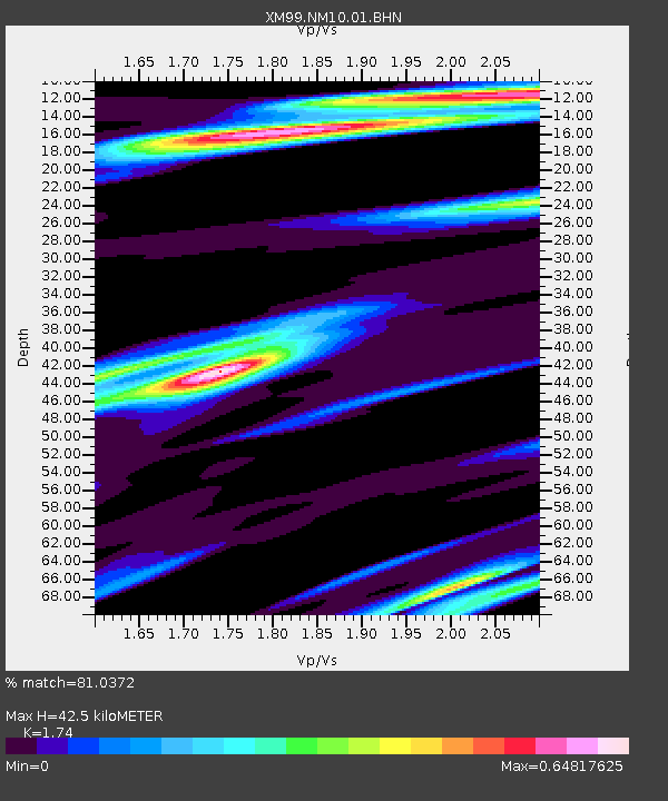
| Estimated Moho Depth: |
42.5 km |
| Estimated Crust Vp/Vs: |
1.74 |
| Assumed Crust Vp: |
6.232 km/s |
| Estimated Crust Vs: |
3.581 km/s |
| Estimated Crust Poisson's Ratio: |
0.25 |
|
| Radial Match: |
81.0372 % |
| Radial Bump: |
385 |
| Transverse Match: |
54.40057 % |
| Transverse Bump: |
400 |
| SOD ConfigId: |
27569 |
| Insert Time: |
2010-02-26 17:21:55.094 +0000 |
| GWidth: |
2.5 |
| Max Bumps: |
400 |
| Tol: |
0.001 |
|

Signal To Noise
| Channel | StoN | STA | LTA |
| XM:NM10:01:BHN:19991127T02:40:47.037026Z | 7.5557165 | 5.775964E-7 | 7.644495E-8 |
| XM:NM10:01:BHE:19991127T02:40:47.037026Z | 4.2768054 | 5.9361105E-7 | 1.3879776E-7 |
| XM:NM10:01:BHZ:19991127T02:40:47.037026Z | 20.286583 | 2.285972E-6 | 1.12683935E-7 |
| Arrivals |
| Ps | 5.3 SECOND |
| PpPs | 18 SECOND |
| PsPs/PpSs | 23 SECOND |


