You are here: Home > Network List > XM99 - Rio Grande Seismic Transect Stations List
> Station NM11 NewMexico11 > Earthquake Result Viewer
NM11 NewMexico11 - Earthquake Result Viewer
| Earthquake location: |
Fiji Islands Region |
| Earthquake latitude/longitude: |
-18.1/-176.9 |
| Earthquake time(UTC): |
2001/04/28 (118) 04:49:53 GMT |
| Earthquake Depth: |
352 km |
| Earthquake Magnitude: |
6.2 MB, 6.8 MW, 6.8 MW |
| Earthquake Catalog/Contributor: |
WHDF/NEIC |
|
| Network: |
XM Rio Grande Seismic Transect |
| Station: |
NM11 NewMexico11 |
| Lat/Lon: |
32.58 N/104.41 W |
| Elevation: |
974 m |
|
| Distance: |
85.6 deg |
| Az: |
53.865 deg |
| Baz: |
245.514 deg |
| Ray Param: |
0.04371539 |
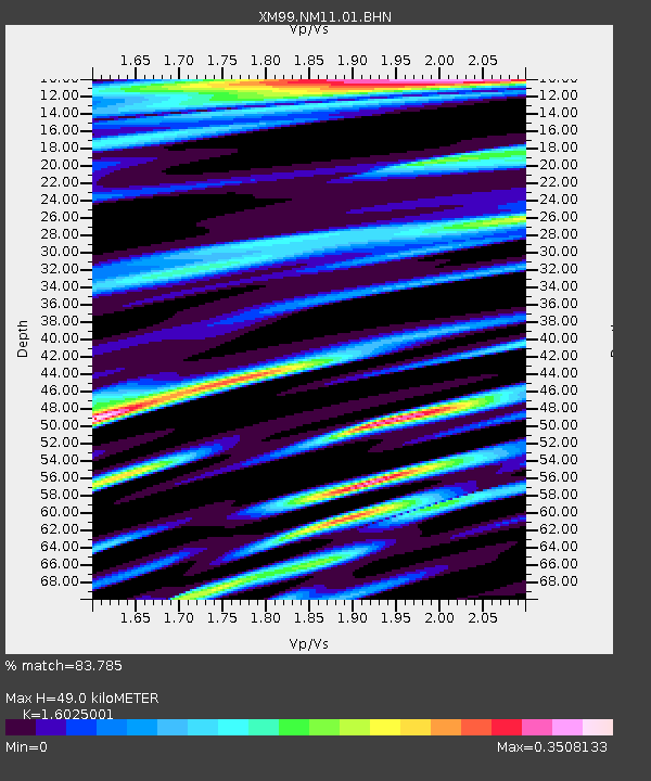
| Estimated Moho Depth: |
49.0 km |
| Estimated Crust Vp/Vs: |
1.60 |
| Assumed Crust Vp: |
6.232 km/s |
| Estimated Crust Vs: |
3.889 km/s |
| Estimated Crust Poisson's Ratio: |
0.18 |
|
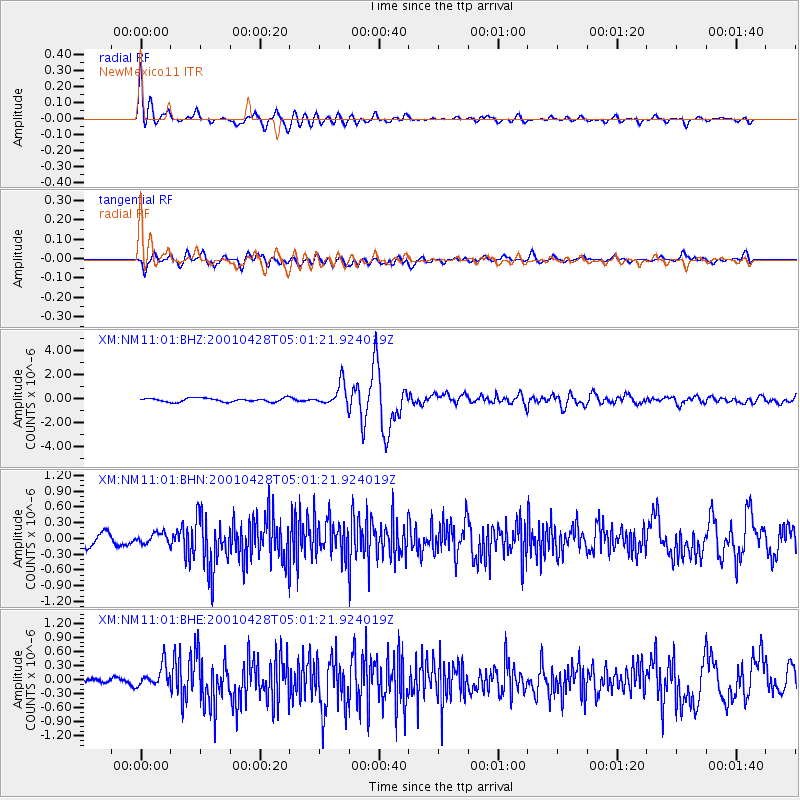
| Radial Match: |
83.785 % |
| Radial Bump: |
400 |
| Transverse Match: |
70.22143 % |
| Transverse Bump: |
400 |
| SOD ConfigId: |
4714 |
| Insert Time: |
2010-02-26 17:22:01.991 +0000 |
| GWidth: |
2.5 |
| Max Bumps: |
400 |
| Tol: |
0.001 |
|
Signal To Noise
| Channel | StoN | STA | LTA |
| XM:NM11:01:BHN:20010428T05:01:21.924019Z | 0.89186066 | 9.95204E-8 | 1.1158738E-7 |
| XM:NM11:01:BHE:20010428T05:01:21.924019Z | 2.984341 | 2.435442E-7 | 8.160737E-8 |
| XM:NM11:01:BHZ:20010428T05:01:21.924019Z | 6.1535645 | 9.4565087E-7 | 1.536753E-7 |
| Arrivals |
| Ps | 4.9 SECOND |
| PpPs | 20 SECOND |
| PsPs/PpSs | 25 SECOND |


