
Station XM NM11 - NewMexico11
Network: XM99 - Rio Grande Seismic Transect
Nearby stations (2 deg radius)
| Station | Name | (Lat, Lon) | Start / End | Elevation |
| NM11 | NewMexico11 | (32.58, -104.41) | 1999-09-11 / 2001-12-31 | 974 m |
| Crust2 Type: | P2,orogen/38km, Alps and Foreland, 2 km seds. |
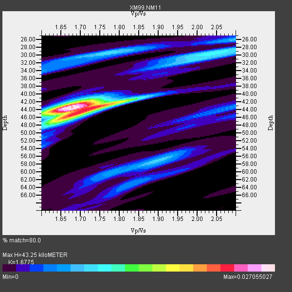
| Thickness Estimate: | 43 km |
| Thickness StdDev: | 5.3 km |
| Vp/Vs Estimate: | 1.68 |
| Vp/Vs StdDev: | 0.09 |
| Vs Estimate: | 3.715 km/s |
| Poisson's Ratio: | 0.22 |
| Peak Value: | 0.03 |
| Assumed Vp: | 6.232 km/s |
| Ps Weight: | 0.33333334 |
| PpPs Weight: | 0.33333334 |
| PsPs Weight: | 0.33333328 |
| Residual Complexity: | 0.628 |
| Nearby stations H: | +- |
| (2.0 deg) Vp/Vs: | +- |
2 with match > 90% ( 22.222221 %) and 8 with match > 80% ( 88.888885 %) out of 9.
Download stack as xyz text file.
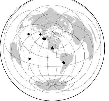
Azimuth Distribution of Events:
Prior Results for this Station
| Study | Thickness | Vp/Vs | Vp | Vs | Poissons Ratio | Extra |
| EARS | 43 km | 1.68 | 6.232 km/s | 3.715 km/s | 0.22 | |
| Crust2.0 | 38 km | 1.76 | 6.232 km/s | 3.534 km/s | 0.26 | P2,orogen/38km, Alps and Foreland, 2 km seds. |
| Wilson | 42 km | 1.73 | 6.26 km/s | 3.618 km/s | 0.25 | |
| Global Maxima | 43 km | 1.68 | 6.232 km/s | 3.715 km/s | 0.22 | amp=0.027055027 |
| Local Maxima 1 | 44 km | 1.71 | 6.232 km/s | 3.639 km/s | 0.24 | amp=0.018336764 |
| Local Maxima 2 | 30 km | 2.04 | 6.232 km/s | 3.055 km/s | 0.34 | amp=0.009286304 |
| Local Maxima 3 | 57 km | 1.90 | 6.232 km/s | 3.271 km/s | 0.31 | amp=0.009126628 |
| Local Maxima 4 | 30 km | 1.76 | 6.232 km/s | 3.541 km/s | 0.26 | amp=0.009099077 |
| Predicted Arrivals for vertical incidence (zero ray parameter) | |
| Ps | 4.70 SECOND |
| PpPs | 18.58 SECOND |
| PsPs/PpSs | 23.29 SECOND |
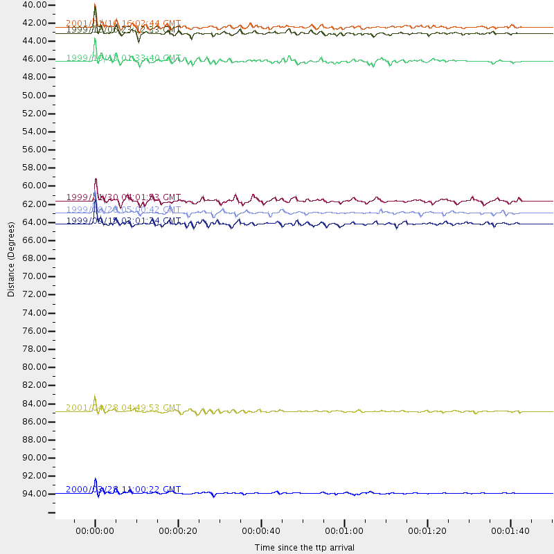
Events Processed for this Station
Download zip of receiver functions as SAC
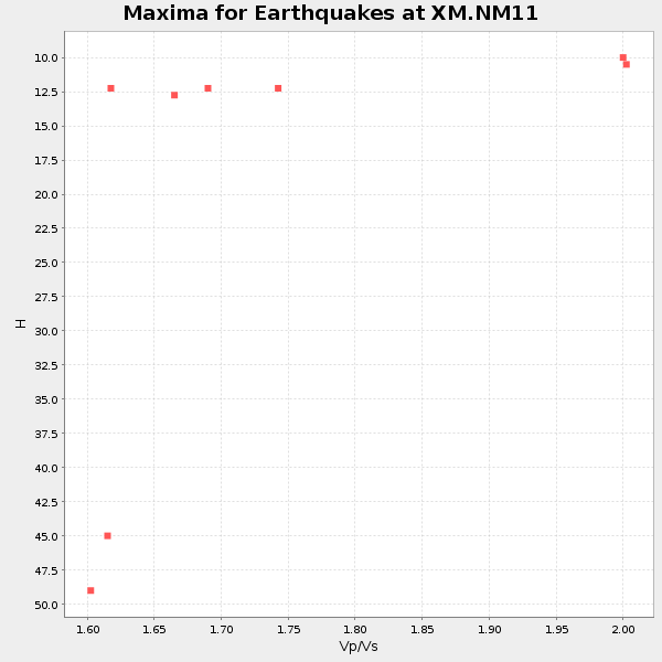
Plot maxima for each earthquake.
Events Used in the Stack
(8 events)| Radial Match | Distance | Baz | FERegion | Time | Lat/Lon | Depth | Magnitude |
| 97.60351 | 95.1 deg | 300.384 deg | Volcano Islands, Japan Region | 2000/03/28 11:00:22 GMT | (22.3, 143.7) | 126 km | 6.8 MB, 7.6 MS, 7.6 MW, 7.6 MW |
| 96.52536 | 41.9 deg | 321.61 deg | Kodiak Island Region, Alaska | 1999/12/06 23:12:33 GMT | (57.4, -154.5) | 66 km | 6.8 MB, 7.0 MW, 7.0 ML |
| 87.8056 | 41.2 deg | 321.388 deg | Kodiak Island Region, Alaska | 2001/01/10 16:02:44 GMT | (57.1, -153.2) | 33 km | 6.2 MB, 6.8 MS, 7.1 MW, 6.8 ML |
| 86.63989 | 64.0 deg | 141.098 deg | Southern Bolivia | 1999/09/15 03:01:24 GMT | (-20.9, -67.3) | 218 km | 6.0 MB, 6.4 MW, 6.4 MW |
| 85.07034 | 45.2 deg | 316.736 deg | Alaska Peninsula | 1999/10/13 01:33:40 GMT | (54.7, -161.2) | 30 km | 6.0 MB, 6.2 MS, 6.5 MW, 6.0 ML |
| 84.125694 | 61.3 deg | 141.482 deg | Northern Chile | 1999/11/30 04:01:53 GMT | (-18.9, -69.2) | 128 km | 6.2 MB, 6.6 MW, 6.5 MW |
| 83.785 | 85.6 deg | 245.514 deg | Fiji Islands Region | 2001/04/28 04:49:53 GMT | (-18.1, -176.9) | 352 km | 6.2 MB, 6.8 MW, 6.8 MW |
| 83.03447 | 62.7 deg | 319.135 deg | Komandorskiye Ostrova Region | 1999/09/28 05:00:42 GMT | (54.6, 168.3) | 33 km | 5.4 MB, 6.1 MS, 6.1 MW, 6.1 MW |
Losers
(1 events)| Radial Match | Distance | Baz | FERegion | Time | Lat/Lon | Depth | Magnitude | Reason |
| 98.70047 | 97.9 deg | 249.081 deg | Southeast Of Loyalty Islands | 2001/02/28 13:05:31 GMT | (-22.0, 170.1) | 10 km | 5.8 MB, 6.1 MS, 6.2 MW |
