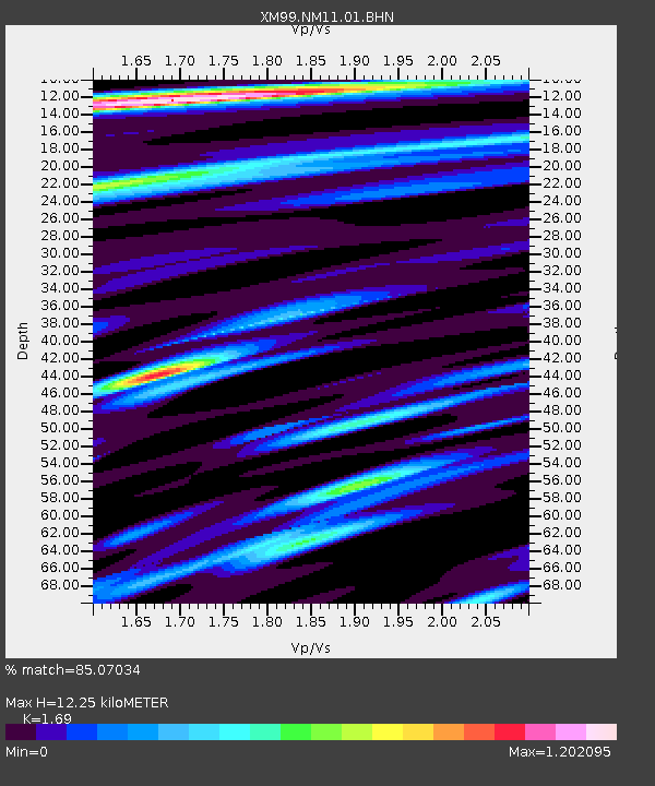
NM11 NewMexico11 - Earthquake Result Viewer
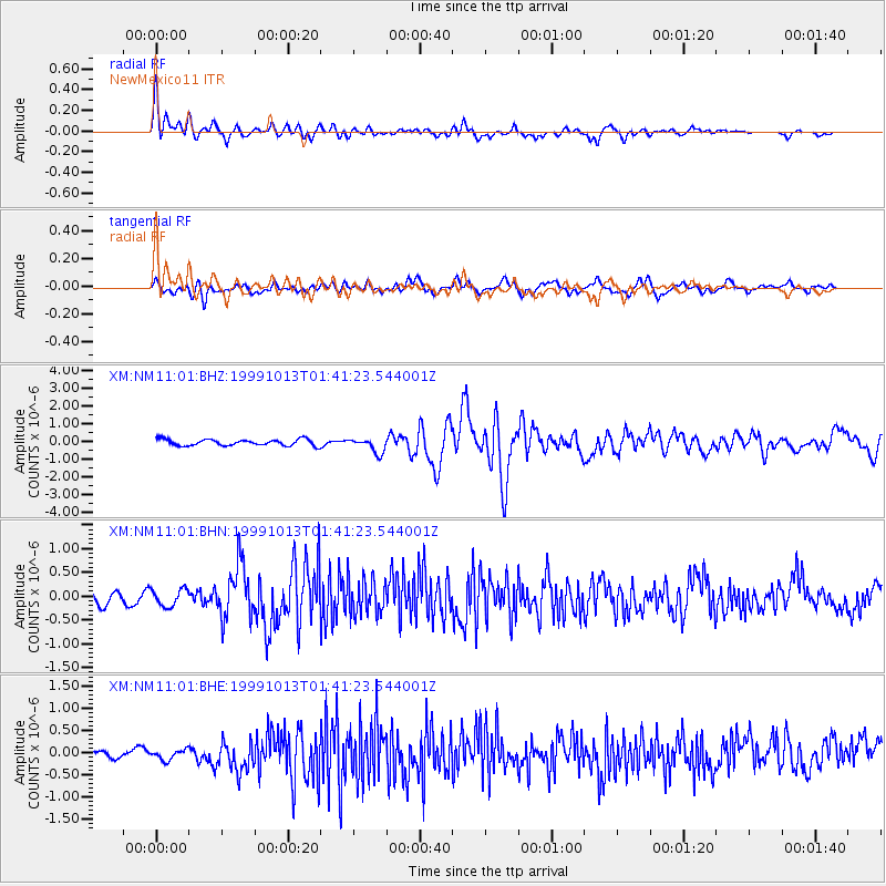
Earthquake location: Alaska Peninsula
Earthquake latitude/longitude: 54.7/-161.2
Earthquake time(UTC): 1999/10/13 (286) 01:33:40 GMT
Earthquake Depth: 30 km
Earthquake Magnitude: 6.0 MB, 6.2 MS, 6.5 MW, 6.0 ML
Earthquake Catalog/Contributor: WHDF/NEIC
Network: XM Rio Grande Seismic Transect
Station: NM11 NewMexico11
Lat/Lon: 32.58 N/104.41 W
Elevation: 974 m
Distance: 45.2 deg
Az: 95.258 deg
Baz: 316.736 deg
Ray Param: 0.07139346
Estimated Moho Depth: 12.25 km
Estimated Crust Vp/Vs: 1.69
Assumed Crust Vp: 6.232 km/s
Estimated Crust Vs: 3.687 km/s
Estimated Crust Poisson's Ratio: 0.23
Radial Match: 85.07034 %
Radial Bump: 400
Transverse Match: 70.306076 %
Transverse Bump: 400
SOD ConfigId: 27569
Insert Time: 2010-02-26 17:22:04.632 +0000
GWidth: 2.5
Max Bumps: 400
Tol: 0.001

Signal To Noise

ChannelStoNSTALTA
XM:NM11:01:BHN:19991013T01:41:23.544001Z1.46287971.8199918E-71.2441159E-7
XM:NM11:01:BHE:19991013T01:41:23.544001Z1.60964111.1805002E-77.333934E-8
XM:NM11:01:BHZ:19991013T01:41:23.544001Z2.36195764.0958736E-71.7341013E-7
Arrivals
Ps1.4 SECOND
PpPs5.0 SECOND
PsPs/PpSs6.4 SECOND