You are here: Home > Network List > XM99 - Rio Grande Seismic Transect Stations List
> Station NM11 NewMexico11 > Earthquake Result Viewer
NM11 NewMexico11 - Earthquake Result Viewer
| Earthquake location: |
Southern Bolivia |
| Earthquake latitude/longitude: |
-20.9/-67.3 |
| Earthquake time(UTC): |
1999/09/15 (258) 03:01:24 GMT |
| Earthquake Depth: |
218 km |
| Earthquake Magnitude: |
6.0 MB, 6.4 MW, 6.4 MW |
| Earthquake Catalog/Contributor: |
WHDF/NEIC |
|
| Network: |
XM Rio Grande Seismic Transect |
| Station: |
NM11 NewMexico11 |
| Lat/Lon: |
32.58 N/104.41 W |
| Elevation: |
974 m |
|
| Distance: |
64.0 deg |
| Az: |
325.447 deg |
| Baz: |
141.098 deg |
| Ray Param: |
0.058563173 |
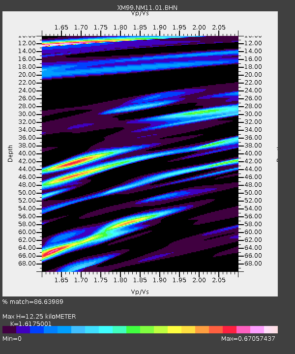
| Estimated Moho Depth: |
12.25 km |
| Estimated Crust Vp/Vs: |
1.62 |
| Assumed Crust Vp: |
6.232 km/s |
| Estimated Crust Vs: |
3.853 km/s |
| Estimated Crust Poisson's Ratio: |
0.19 |
|
| Radial Match: |
86.63989 % |
| Radial Bump: |
400 |
| Transverse Match: |
72.0476 % |
| Transverse Bump: |
400 |
| SOD ConfigId: |
27569 |
| Insert Time: |
2010-02-26 17:22:06.388 +0000 |
| GWidth: |
2.5 |
| Max Bumps: |
400 |
| Tol: |
0.001 |
|
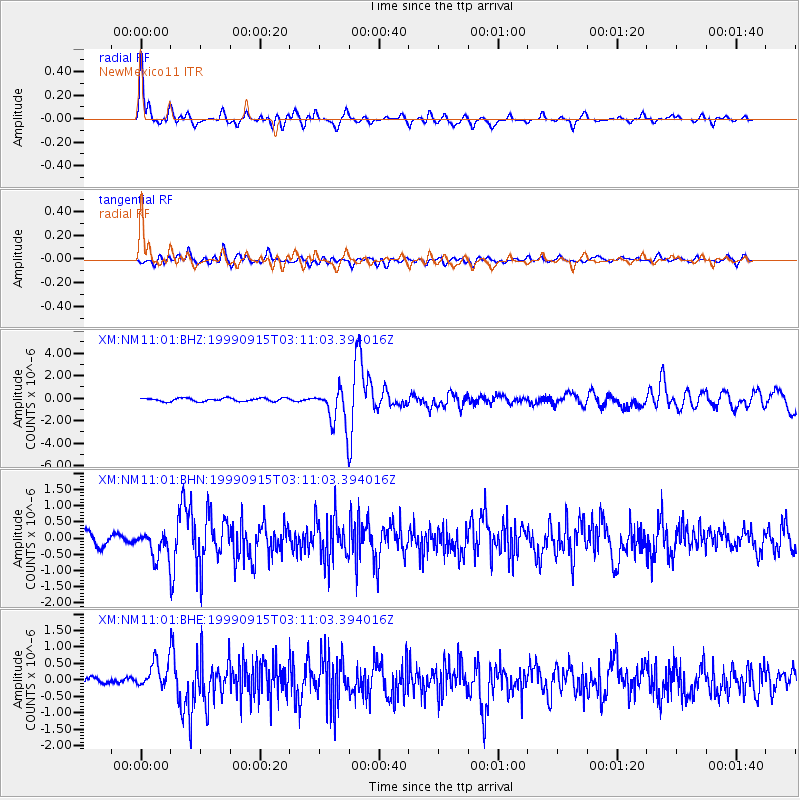
Signal To Noise
| Channel | StoN | STA | LTA |
| XM:NM11:01:BHN:19990915T03:11:03.394016Z | 2.9514978 | 4.0255085E-7 | 1.3638868E-7 |
| XM:NM11:01:BHE:19990915T03:11:03.394016Z | 3.7356234 | 4.133783E-7 | 1.1065845E-7 |
| XM:NM11:01:BHZ:19990915T03:11:03.394016Z | 11.6331005 | 1.6777651E-6 | 1.4422339E-7 |
| Arrivals |
| Ps | 1.3 SECOND |
| PpPs | 4.9 SECOND |
| PsPs/PpSs | 6.2 SECOND |


