NM11 NewMexico11 - Earthquake Result Viewer
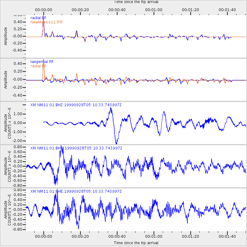
Earthquake location: Komandorskiye Ostrova Region
Earthquake latitude/longitude: 54.6/168.3
Earthquake time(UTC): 1999/09/28 (271) 05:00:42 GMT
Earthquake Depth: 33 km
Earthquake Magnitude: 5.4 MB, 6.1 MS, 6.1 MW, 6.1 MW
Earthquake Catalog/Contributor: WHDF/NEIC
Network: XM Rio Grande Seismic Transect
Station: NM11 NewMexico11
Lat/Lon: 32.58 N/104.41 W
Elevation: 974 m
Distance: 62.7 deg
Az: 71.637 deg
Baz: 319.135 deg
Ray Param: 0.06000447
Estimated Moho Depth: 45.0 km
Estimated Crust Vp/Vs: 1.62
Assumed Crust Vp: 6.232 km/s
Estimated Crust Vs: 3.859 km/s
Estimated Crust Poisson's Ratio: 0.19
Radial Match: 83.03447 %
Radial Bump: 283
Transverse Match: 58.198467 %
Transverse Bump: 400
SOD ConfigId: 27569
Insert Time: 2010-02-26 17:22:07.867 +0000
GWidth: 2.5
Max Bumps: 400
Tol: 0.001

Signal To Noise

ChannelStoNSTALTA
XM:NM11:01:BHN:19990928T05:10:33.743997Z1.27483121.0792328E-78.465692E-8
XM:NM11:01:BHE:19990928T05:10:33.743997Z1.25285091.1606175E-79.2638125E-8
XM:NM11:01:BHZ:19990928T05:10:33.743997Z2.31851222.4160377E-71.04206386E-7
Arrivals
Ps4.6 SECOND
PpPs18 SECOND
PsPs/PpSs23 SECOND