You are here: Home > Network List > XM99 - Rio Grande Seismic Transect Stations List
> Station NM11 NewMexico11 > Earthquake Result Viewer
NM11 NewMexico11 - Earthquake Result Viewer
| Earthquake location: |
Kodiak Island Region, Alaska |
| Earthquake latitude/longitude: |
57.4/-154.5 |
| Earthquake time(UTC): |
1999/12/06 (340) 23:12:33 GMT |
| Earthquake Depth: |
66 km |
| Earthquake Magnitude: |
6.8 MB, 7.0 MW, 7.0 ML |
| Earthquake Catalog/Contributor: |
WHDF/NEIC |
|
| Network: |
XM Rio Grande Seismic Transect |
| Station: |
NM11 NewMexico11 |
| Lat/Lon: |
32.58 N/104.41 W |
| Elevation: |
974 m |
|
| Distance: |
41.9 deg |
| Az: |
104.342 deg |
| Baz: |
321.61 deg |
| Ray Param: |
0.07327649 |
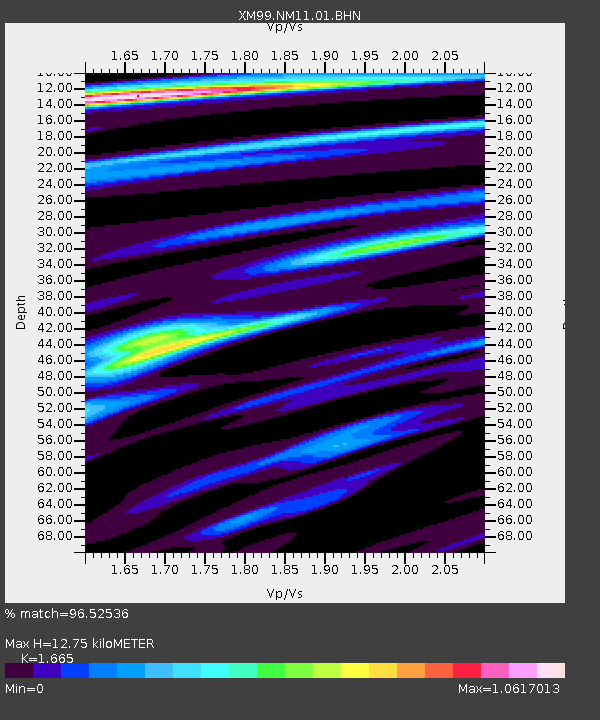
| Estimated Moho Depth: |
12.75 km |
| Estimated Crust Vp/Vs: |
1.66 |
| Assumed Crust Vp: |
6.232 km/s |
| Estimated Crust Vs: |
3.743 km/s |
| Estimated Crust Poisson's Ratio: |
0.22 |
|
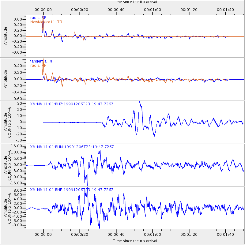
| Radial Match: |
96.52536 % |
| Radial Bump: |
336 |
| Transverse Match: |
85.45401 % |
| Transverse Bump: |
400 |
| SOD ConfigId: |
27569 |
| Insert Time: |
2010-02-26 17:22:09.047 +0000 |
| GWidth: |
2.5 |
| Max Bumps: |
400 |
| Tol: |
0.001 |
|
Signal To Noise
| Channel | StoN | STA | LTA |
| XM:NM11:01:BHN:19991206T23:19:47.726Z | 5.0303736 | 9.185177E-7 | 1.8259433E-7 |
| XM:NM11:01:BHE:19991206T23:19:47.726Z | 3.7770689 | 7.7969185E-7 | 2.0642776E-7 |
| XM:NM11:01:BHZ:19991206T23:19:47.726Z | 18.328186 | 3.1538611E-6 | 1.720771E-7 |
| Arrivals |
| Ps | 1.5 SECOND |
| PpPs | 5.1 SECOND |
| PsPs/PpSs | 6.6 SECOND |


