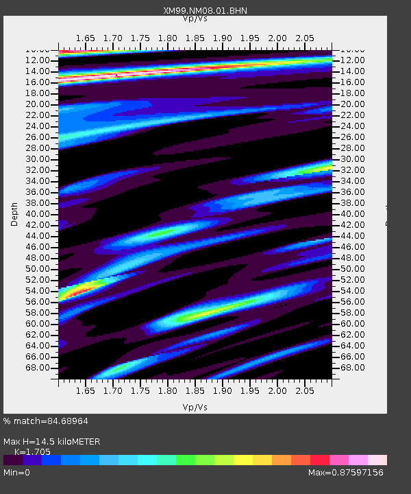
NM08 NewMexico08 - Earthquake Result Viewer

Earthquake location: Windward Islands
Earthquake latitude/longitude: 11.1/-62.6
Earthquake time(UTC): 2000/10/04 (278) 14:37:44 GMT
Earthquake Depth: 110 km
Earthquake Magnitude: 5.6 MB, 5.4 MS, 6.1 MW, 5.9 MD
Earthquake Catalog/Contributor: WHDF/NEIC
Network: XM Rio Grande Seismic Transect
Station: NM08 NewMexico08
Lat/Lon: 32.20 N/103.97 W
Elevation: 886 m
Distance: 43.5 deg
Az: 305.403 deg
Baz: 109.336 deg
Ray Param: 0.07213395
Estimated Moho Depth: 14.5 km
Estimated Crust Vp/Vs: 1.71
Assumed Crust Vp: 6.129 km/s
Estimated Crust Vs: 3.595 km/s
Estimated Crust Poisson's Ratio: 0.24
Radial Match: 84.68964 %
Radial Bump: 400
Transverse Match: 71.851036 %
Transverse Bump: 400
SOD ConfigId: 16820
Insert Time: 2010-02-26 17:22:17.211 +0000
GWidth: 2.5
Max Bumps: 400
Tol: 0.001

Signal To Noise

ChannelStoNSTALTA
XM:NM08:01:BHN:20001004T14:45:05.940009Z1.58460082.0049269E-71.2652568E-7
XM:NM08:01:BHE:20001004T14:45:05.940009Z4.0676117.366659E-71.811053E-7
XM:NM08:01:BHZ:20001004T14:45:05.940009Z6.74522831.3390113E-61.9851238E-7
Arrivals
Ps1.8 SECOND
PpPs6.0 SECOND
PsPs/PpSs7.8 SECOND