
Station XM NM08 - NewMexico08
Network: XM99 - Rio Grande Seismic Transect
Nearby stations (2 deg radius)
| Station | Name | (Lat, Lon) | Start / End | Elevation |
| NM08 | NewMexico08 | (32.20, -103.97) | 1999-09-11 / 2001-12-31 | 886 m |
| Crust2 Type: | P5,orogen/45km, Orogen, 4 km seds. |
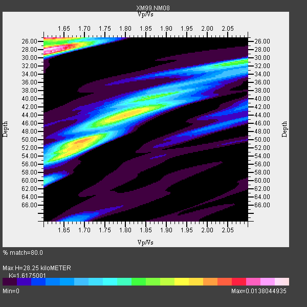
| Thickness Estimate: | 28 km |
| Thickness StdDev: | 8.8 km |
| Vp/Vs Estimate: | 1.62 |
| Vp/Vs StdDev: | 0.06 |
| Vs Estimate: | 3.789 km/s |
| Poisson's Ratio: | 0.19 |
| Peak Value: | 0.01 |
| Assumed Vp: | 6.129 km/s |
| Ps Weight: | 0.33333334 |
| PpPs Weight: | 0.33333334 |
| PsPs Weight: | 0.33333328 |
| Residual Complexity: | 0.886 |
| Nearby stations H: | +- |
| (2.0 deg) Vp/Vs: | +- |
6 with match > 90% ( 37.5 %) and 15 with match > 80% ( 93.75 %) out of 16.
Download stack as xyz text file.
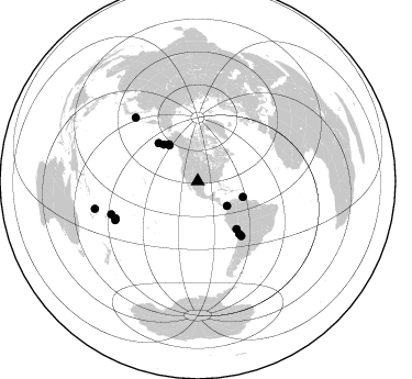
Azimuth Distribution of Events:
Prior Results for this Station
| Study | Thickness | Vp/Vs | Vp | Vs | Poissons Ratio | Extra |
| EARS | 28 km | 1.62 | 6.129 km/s | 3.789 km/s | 0.19 | |
| Crust2.0 | 45 km | 1.76 | 6.129 km/s | 3.476 km/s | 0.26 | P5,orogen/45km, Orogen, 4 km seds. |
| Wilson | 42 km | 1.74 | 6.23 km/s | 3.58 km/s | 0.25 | |
| Global Maxima | 28 km | 1.62 | 6.129 km/s | 3.789 km/s | 0.19 | amp=0.0138044935 |
| Local Maxima 1 | 25 km | 1.62 | 6.129 km/s | 3.795 km/s | 0.19 | amp=0.011085924 |
| Local Maxima 2 | 50 km | 1.70 | 6.129 km/s | 3.611 km/s | 0.23 | amp=0.010265915 |
| Local Maxima 3 | 44 km | 1.82 | 6.129 km/s | 3.377 km/s | 0.28 | amp=0.008335926 |
| Local Maxima 4 | 31 km | 2.07 | 6.129 km/s | 2.964 km/s | 0.35 | amp=0.0070425435 |
| Predicted Arrivals for vertical incidence (zero ray parameter) | |
| Ps | 2.85 SECOND |
| PpPs | 12.06 SECOND |
| PsPs/PpSs | 14.91 SECOND |
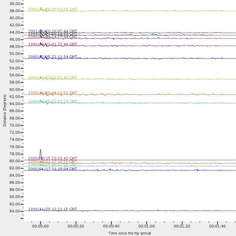
Events Processed for this Station
Download zip of receiver functions as SAC
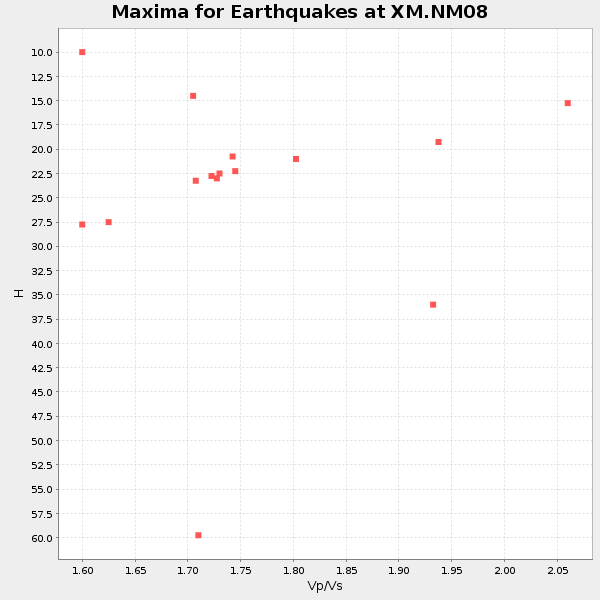
Plot maxima for each earthquake.
Events Used in the Stack
(15 events)| Radial Match | Distance | Baz | FERegion | Time | Lat/Lon | Depth | Magnitude |
| 99.99947 | 81.0 deg | 315.529 deg | Kuril Islands | 2000/08/15 20:20:43 GMT | (43.0, 146.8) | 33 km | 5.7 MB, 5.3 MS, 5.9 MW, 5.8 MW |
| 97.158615 | 42.5 deg | 321.785 deg | Kodiak Island Region, Alaska | 1999/12/06 23:12:33 GMT | (57.4, -154.5) | 66 km | 6.8 MB, 7.0 MW, 7.0 ML |
| 93.3866 | 83.0 deg | 244.798 deg | Tonga Islands | 2000/09/26 06:17:52 GMT | (-17.2, -173.9) | 56 km | 6.1 MB, 6.1 MS, 6.4 MW, 6.1 ME |
| 92.54981 | 63.4 deg | 141.354 deg | Southern Bolivia | 1999/09/15 03:01:24 GMT | (-20.9, -67.3) | 218 km | 6.0 MB, 6.4 MW, 6.4 MW |
| 91.77732 | 96.8 deg | 254.963 deg | Vanuatu Islands | 1999/11/26 13:21:15 GMT | (-16.4, 168.2) | 33 km | 6.4 MB, 7.3 MS, 7.5 MW, 7.3 MW |
| 91.101135 | 42.5 deg | 321.707 deg | Kodiak Island Region, Alaska | 1999/12/07 00:19:49 GMT | (57.4, -154.5) | 41 km | 6.5 MB, 6.1 MS, 6.4 MW, 6.3 ML |
| 88.91391 | 49.6 deg | 314.0 deg | Fox Islands, Aleutian Islands | 2000/12/05 22:11:34 GMT | (52.6, -167.8) | 33 km | 5.6 MB, 5.6 MS, 5.9 MW, 5.4 ML |
| 86.83697 | 56.0 deg | 140.907 deg | Central Peru | 1999/11/27 02:31:49 GMT | (-14.5, -71.3) | 126 km | 5.8 MB, 5.9 MW, 5.9 MW |
| 86.798035 | 41.7 deg | 321.564 deg | Kodiak Island Region, Alaska | 2001/01/10 16:02:44 GMT | (57.1, -153.2) | 33 km | 6.2 MB, 6.8 MS, 7.1 MW, 6.8 ML |
| 86.21017 | 84.3 deg | 249.042 deg | Fiji Islands Region | 2000/01/17 21:18:04 GMT | (-14.5, -177.6) | 33 km | 5.6 MB, 5.7 MS, 5.9 MW, 5.8 MW |
| 84.68964 | 43.5 deg | 109.336 deg | Windward Islands | 2000/10/04 14:37:44 GMT | (11.1, -62.6) | 110 km | 5.6 MB, 5.4 MS, 6.1 MW, 5.9 MD |
| 84.34641 | 34.9 deg | 130.175 deg | Panama-Colombia Border Region | 2000/11/08 06:59:58 GMT | (7.0, -77.8) | 17 km | 6.0 MB, 6.4 MS, 6.5 MW, 6.2 ML |
| 84.1967 | 60.8 deg | 141.743 deg | Northern Chile | 1999/11/30 04:01:53 GMT | (-18.9, -69.2) | 128 km | 6.2 MB, 6.6 MW, 6.5 MW |
| 81.4292 | 45.7 deg | 316.962 deg | Alaska Peninsula | 1999/10/13 01:33:40 GMT | (54.7, -161.2) | 30 km | 6.0 MB, 6.2 MS, 6.5 MW, 6.0 ML |
| 81.29498 | 82.0 deg | 245.709 deg | Tonga Islands | 2000/09/11 17:17:53 GMT | (-15.9, -173.7) | 115 km | 6.0 MB, 6.3 MW, 6.3 MW |
Losers
(1 events)| Radial Match | Distance | Baz | FERegion | Time | Lat/Lon | Depth | Magnitude | Reason |
| 94.29905 | 98.1 deg | 249.245 deg | Southeast Of Loyalty Islands | 2001/02/28 13:05:31 GMT | (-22.0, 170.1) | 10 km | 5.8 MB, 6.1 MS, 6.2 MW |
