You are here: Home > Network List > XM99 - Rio Grande Seismic Transect Stations List
> Station NM07 NewMexico07 > Earthquake Result Viewer
NM07 NewMexico07 - Earthquake Result Viewer
| Earthquake location: |
Chile-Bolivia Border Region |
| Earthquake latitude/longitude: |
-21.8/-68.8 |
| Earthquake time(UTC): |
1999/11/21 (325) 03:51:14 GMT |
| Earthquake Depth: |
101 km |
| Earthquake Magnitude: |
5.9 MB, 6.0 MW, 5.8 MW |
| Earthquake Catalog/Contributor: |
WHDF/NEIC |
|
| Network: |
XM Rio Grande Seismic Transect |
| Station: |
NM07 NewMexico07 |
| Lat/Lon: |
32.08 N/103.84 W |
| Elevation: |
966 m |
|
| Distance: |
63.2 deg |
| Az: |
326.879 deg |
| Baz: |
143.244 deg |
| Ray Param: |
0.059471507 |
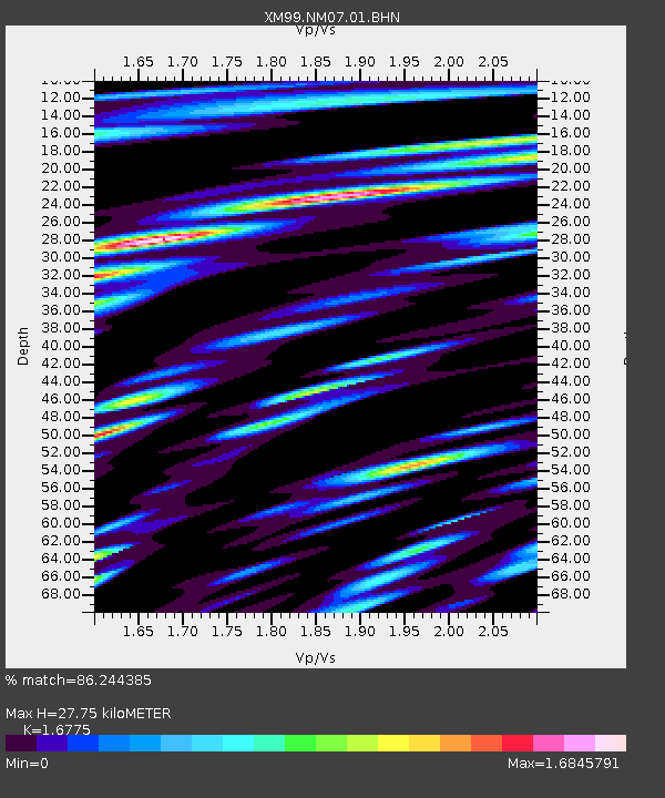
| Estimated Moho Depth: |
27.75 km |
| Estimated Crust Vp/Vs: |
1.68 |
| Assumed Crust Vp: |
6.129 km/s |
| Estimated Crust Vs: |
3.654 km/s |
| Estimated Crust Poisson's Ratio: |
0.22 |
|
| Radial Match: |
86.244385 % |
| Radial Bump: |
400 |
| Transverse Match: |
85.1322 % |
| Transverse Bump: |
400 |
| SOD ConfigId: |
27569 |
| Insert Time: |
2010-02-26 17:22:39.905 +0000 |
| GWidth: |
2.5 |
| Max Bumps: |
400 |
| Tol: |
0.001 |
|
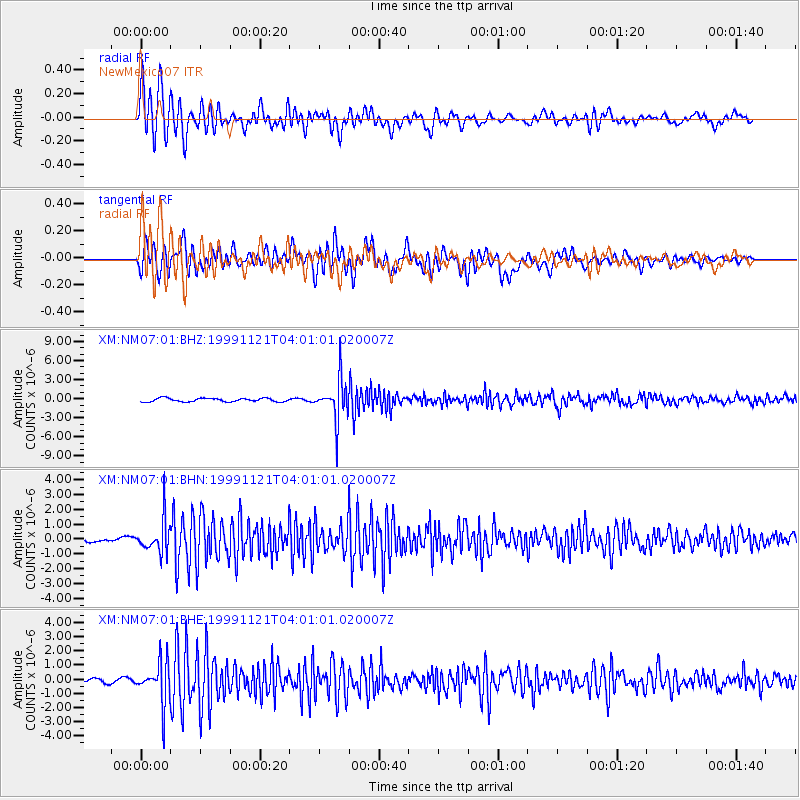
Signal To Noise
| Channel | StoN | STA | LTA |
| XM:NM07:01:BHN:19991121T04:01:01.020007Z | 6.5028415 | 1.1288859E-6 | 1.7359885E-7 |
| XM:NM07:01:BHE:19991121T04:01:01.020007Z | 11.082431 | 1.447372E-6 | 1.3060058E-7 |
| XM:NM07:01:BHZ:19991121T04:01:01.020007Z | 11.79825 | 3.2542584E-6 | 2.758255E-7 |
| Arrivals |
| Ps | 3.2 SECOND |
| PpPs | 12 SECOND |
| PsPs/PpSs | 15 SECOND |


