
Station XM NM07 - NewMexico07
Network: XM99 - Rio Grande Seismic Transect
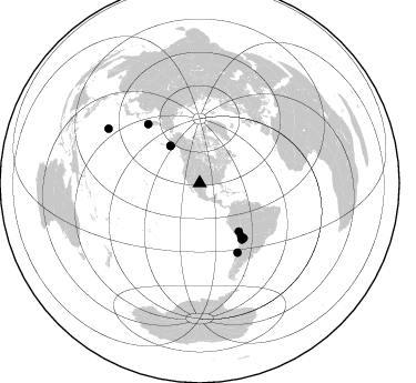
Nearby stations (2 deg radius)
| Station | Name | (Lat, Lon) | Start / End | Elevation |
| NM07 | NewMexico07 | (32.08, -103.84) | 1999-09-11 / 2001-12-31 | 966 m |
| Crust2 Type: | P5,orogen/45km, Orogen, 4 km seds. |
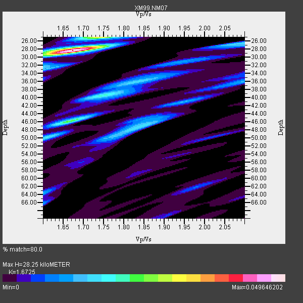
| Thickness Estimate: | 28 km |
| Thickness StdDev: | 5.0 km |
| Vp/Vs Estimate: | 1.67 |
| Vp/Vs StdDev: | 0.04 |
| Vs Estimate: | 3.665 km/s |
| Poisson's Ratio: | 0.22 |
| Peak Value: | 0.05 |
| Assumed Vp: | 6.129 km/s |
| Ps Weight: | 0.33333334 |
| PpPs Weight: | 0.33333334 |
| PsPs Weight: | 0.33333328 |
| Residual Complexity: | 0.667 |
| Nearby stations H: | +- |
| (2.0 deg) Vp/Vs: | +- |
3 with match > 90% ( 27.272728 %) and 9 with match > 80% ( 81.818184 %) out of 11.
Download stack as xyz text file.
Azimuth Distribution of Events:
Prior Results for this Station
| Study | Thickness | Vp/Vs | Vp | Vs | Poissons Ratio | Extra |
| EARS | 28 km | 1.67 | 6.129 km/s | 3.665 km/s | 0.22 | |
| Crust2.0 | 45 km | 1.76 | 6.129 km/s | 3.476 km/s | 0.26 | P5,orogen/45km, Orogen, 4 km seds. |
| Wilson | 42 km | 1.74 | 6.24 km/s | 3.586 km/s | 0.25 | |
| Global Maxima | 28 km | 1.67 | 6.129 km/s | 3.665 km/s | 0.22 | amp=0.049646202 |
| Local Maxima 1 | 46 km | 1.67 | 6.129 km/s | 3.67 km/s | 0.22 | amp=0.025042584 |
| Local Maxima 2 | 25 km | 1.74 | 6.129 km/s | 3.527 km/s | 0.25 | amp=0.023564339 |
| Local Maxima 3 | 47 km | 1.84 | 6.129 km/s | 3.34 km/s | 0.29 | amp=0.01694904 |
| Local Maxima 4 | 40 km | 1.74 | 6.129 km/s | 3.522 km/s | 0.25 | amp=0.016731262 |
| Predicted Arrivals for vertical incidence (zero ray parameter) | |
| Ps | 3.10 SECOND |
| PpPs | 12.32 SECOND |
| PsPs/PpSs | 15.42 SECOND |
Events Processed for this Station
Download zip of receiver functions as SAC
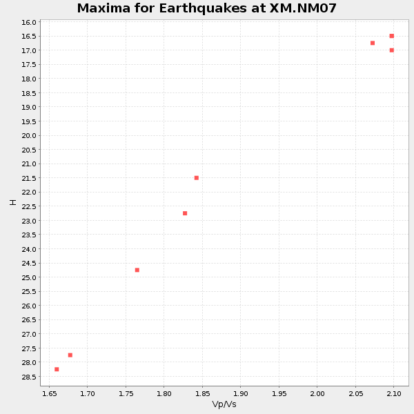
Plot maxima for each earthquake.
Events Used in the Stack
(9 events)| Radial Match | Distance | Baz | FERegion | Time | Lat/Lon | Depth | Magnitude |
| 94.51059 | 95.7 deg | 300.669 deg | Volcano Islands, Japan Region | 2000/03/28 11:00:22 GMT | (22.3, 143.7) | 126 km | 6.8 MB, 7.6 MS, 7.6 MW, 7.6 MW |
| 93.163536 | 63.3 deg | 141.432 deg | Southern Bolivia | 1999/09/15 03:01:24 GMT | (-20.9, -67.3) | 218 km | 6.0 MB, 6.4 MW, 6.4 MW |
| 92.93548 | 42.6 deg | 321.836 deg | Kodiak Island Region, Alaska | 1999/12/06 23:12:33 GMT | (57.4, -154.5) | 66 km | 6.8 MB, 7.0 MW, 7.0 ML |
| 87.42084 | 55.9 deg | 140.987 deg | Central Peru | 1999/11/27 02:31:49 GMT | (-14.5, -71.3) | 126 km | 5.8 MB, 5.9 MW, 5.9 MW |
| 87.32651 | 60.6 deg | 141.823 deg | Northern Chile | 1999/11/30 04:01:53 GMT | (-18.9, -69.2) | 128 km | 6.2 MB, 6.6 MW, 6.5 MW |
| 86.244385 | 63.2 deg | 143.244 deg | Chile-Bolivia Border Region | 1999/11/21 03:51:14 GMT | (-21.8, -68.8) | 101 km | 5.9 MB, 6.0 MW, 5.8 MW |
| 85.4013 | 71.0 deg | 151.368 deg | Near Coast Of Central Chile | 2001/03/15 13:02:42 GMT | (-32.3, -71.5) | 37 km | 6.1 MB, 5.6 MS, 6.0 MW, 5.4 MD |
| 83.01573 | 70.7 deg | 318.765 deg | Near East Coast Of Kamchatka | 1999/09/18 21:28:33 GMT | (51.2, 157.6) | 60 km | 5.9 MB, 5.6 MS, 6.2 MW, 6.0 MW |
| 80.714584 | 42.6 deg | 321.758 deg | Kodiak Island Region, Alaska | 1999/12/07 00:19:49 GMT | (57.4, -154.5) | 41 km | 6.5 MB, 6.1 MS, 6.4 MW, 6.3 ML |
Losers
(2 events)| Radial Match | Distance | Baz | FERegion | Time | Lat/Lon | Depth | Magnitude | Reason |
| 86.47362 | 45.9 deg | 317.028 deg | Alaska Peninsula | 1999/10/13 01:33:40 GMT | (54.7, -161.2) | 30 km | 6.0 MB, 6.2 MS, 6.5 MW, 6.0 ML | |
| 83.23965 | 91.4 deg | 312.411 deg | Near S. Coast Of Honshu, Japan | 2000/07/01 07:01:55 GMT | (34.2, 139.1) | 10 km | 6.0 MB, 6.1 MS, 6.2 MW, 6.2 MW |
