You are here: Home > Network List > XM99 - Rio Grande Seismic Transect Stations List
> Station NM07 NewMexico07 > Earthquake Result Viewer
NM07 NewMexico07 - Earthquake Result Viewer
| Earthquake location: |
Southern Bolivia |
| Earthquake latitude/longitude: |
-20.9/-67.3 |
| Earthquake time(UTC): |
1999/09/15 (258) 03:01:24 GMT |
| Earthquake Depth: |
218 km |
| Earthquake Magnitude: |
6.0 MB, 6.4 MW, 6.4 MW |
| Earthquake Catalog/Contributor: |
WHDF/NEIC |
|
| Network: |
XM Rio Grande Seismic Transect |
| Station: |
NM07 NewMexico07 |
| Lat/Lon: |
32.08 N/103.84 W |
| Elevation: |
966 m |
|
| Distance: |
63.3 deg |
| Az: |
325.519 deg |
| Baz: |
141.432 deg |
| Ray Param: |
0.05900063 |
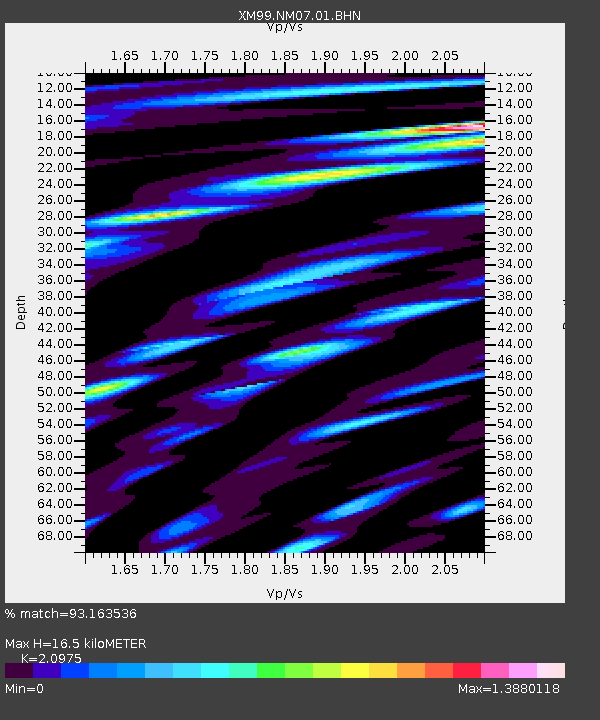
| Estimated Moho Depth: |
16.5 km |
| Estimated Crust Vp/Vs: |
2.10 |
| Assumed Crust Vp: |
6.129 km/s |
| Estimated Crust Vs: |
2.922 km/s |
| Estimated Crust Poisson's Ratio: |
0.35 |
|
| Radial Match: |
93.163536 % |
| Radial Bump: |
400 |
| Transverse Match: |
88.53301 % |
| Transverse Bump: |
400 |
| SOD ConfigId: |
27569 |
| Insert Time: |
2010-02-26 17:22:40.996 +0000 |
| GWidth: |
2.5 |
| Max Bumps: |
400 |
| Tol: |
0.001 |
|
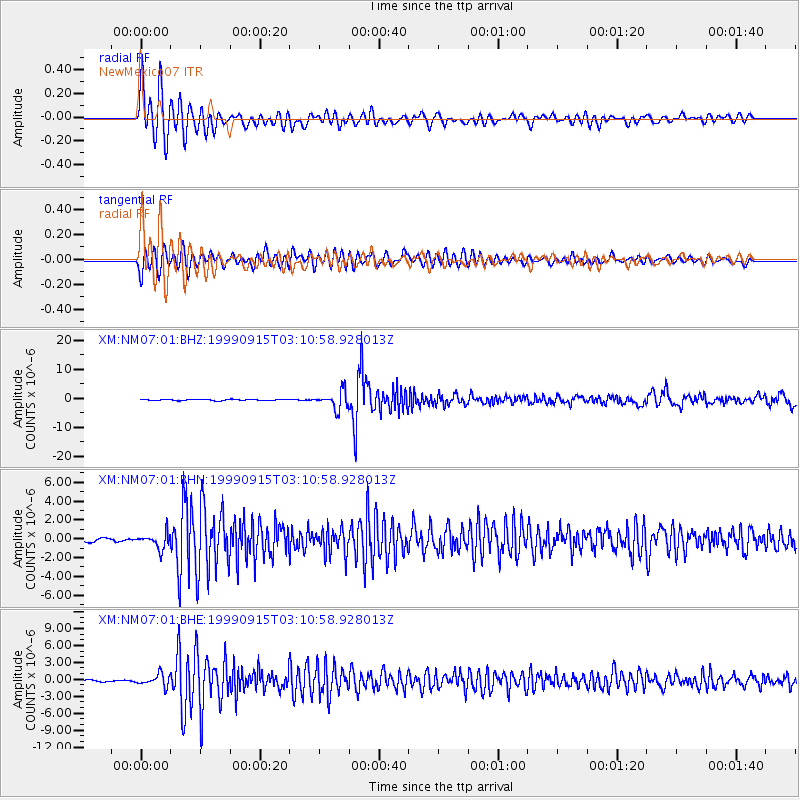
Signal To Noise
| Channel | StoN | STA | LTA |
| XM:NM07:01:BHN:19990915T03:10:58.928013Z | 3.0158596 | 8.1759737E-7 | 2.7109928E-7 |
| XM:NM07:01:BHE:19990915T03:10:58.928013Z | 4.8201528 | 1.0367355E-6 | 2.1508355E-7 |
| XM:NM07:01:BHZ:19990915T03:10:58.928013Z | 15.448313 | 3.0824824E-6 | 1.9953521E-7 |
| Arrivals |
| Ps | 3.1 SECOND |
| PpPs | 8.1 SECOND |
| PsPs/PpSs | 11 SECOND |


