You are here: Home > Network List > KR - Kyrgyz Digital Network Stations List
> Station MNAS Manas, Kyrgyzstan > Earthquake Result Viewer
MNAS Manas, Kyrgyzstan - Earthquake Result Viewer
| Earthquake location: |
Mindanao, Philippines |
| Earthquake latitude/longitude: |
7.0/126.9 |
| Earthquake time(UTC): |
2022/04/20 (110) 21:57:46 GMT |
| Earthquake Depth: |
51 km |
| Earthquake Magnitude: |
6.0 mww |
| Earthquake Catalog/Contributor: |
NEIC PDE/us |
|
| Network: |
KR Kyrgyz Digital Network |
| Station: |
MNAS Manas, Kyrgyzstan |
| Lat/Lon: |
42.49 N/72.50 E |
| Elevation: |
1465 m |
|
| Distance: |
59.5 deg |
| Az: |
315.676 deg |
| Baz: |
110.325 deg |
| Ray Param: |
0.06205924 |
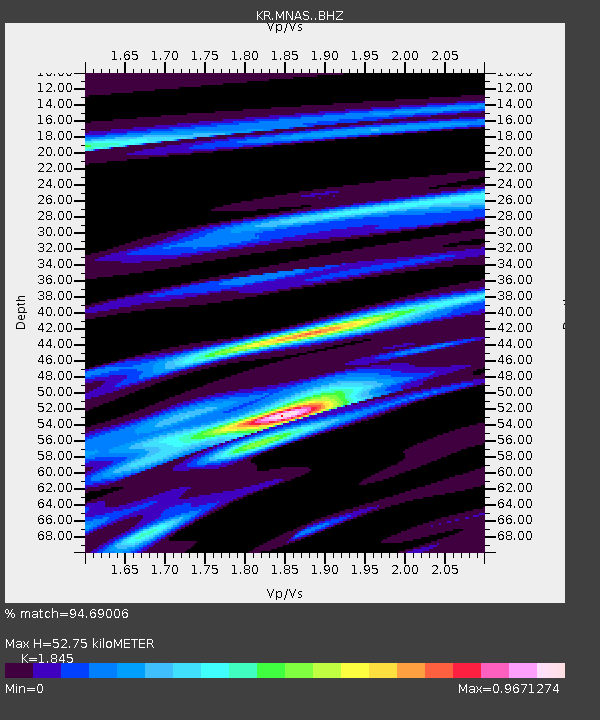
| Estimated Moho Depth: |
52.75 km |
| Estimated Crust Vp/Vs: |
1.85 |
| Assumed Crust Vp: |
6.316 km/s |
| Estimated Crust Vs: |
3.423 km/s |
| Estimated Crust Poisson's Ratio: |
0.29 |
|
| Radial Match: |
94.69006 % |
| Radial Bump: |
322 |
| Transverse Match: |
86.941055 % |
| Transverse Bump: |
400 |
| SOD ConfigId: |
27527651 |
| Insert Time: |
2022-05-04 22:09:49.190 +0000 |
| GWidth: |
2.5 |
| Max Bumps: |
400 |
| Tol: |
0.001 |
|

Signal To Noise
| Channel | StoN | STA | LTA |
| KR:MNAS: :BHZ:20220420T22:07:13.619999Z | 28.309181 | 1.0559063E-6 | 3.7299078E-8 |
| KR:MNAS: :BHN:20220420T22:07:13.619999Z | 4.5701466 | 1.2960471E-7 | 2.8358984E-8 |
| KR:MNAS: :BHE:20220420T22:07:13.619999Z | 19.165516 | 4.9007906E-7 | 2.5570879E-8 |
| Arrivals |
| Ps | 7.4 SECOND |
| PpPs | 23 SECOND |
| PsPs/PpSs | 30 SECOND |


