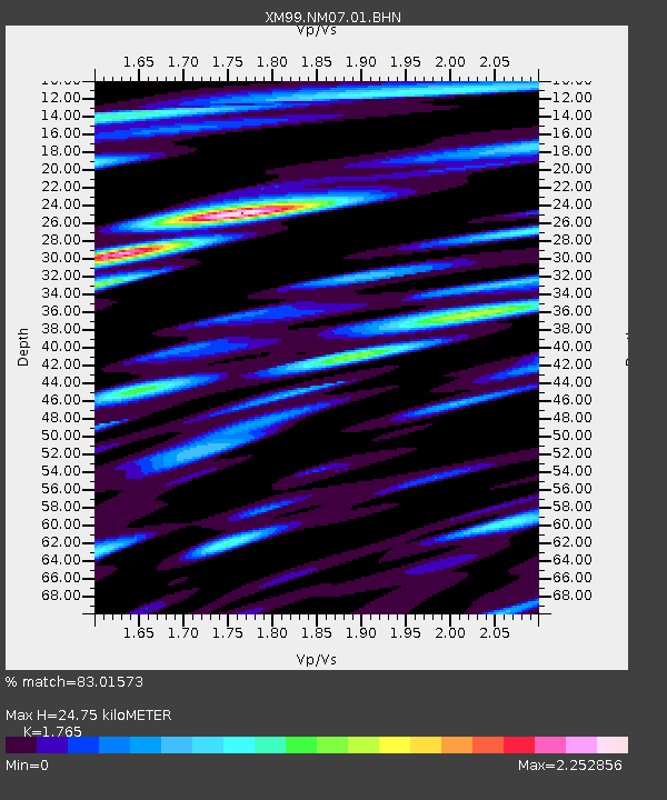
NM07 NewMexico07 - Earthquake Result Viewer
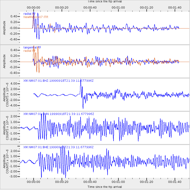
Earthquake location: Near East Coast Of Kamchatka
Earthquake latitude/longitude: 51.2/157.6
Earthquake time(UTC): 1999/09/18 (261) 21:28:33 GMT
Earthquake Depth: 60 km
Earthquake Magnitude: 5.9 MB, 5.6 MS, 6.2 MW, 6.0 MW
Earthquake Catalog/Contributor: WHDF/NEIC
Network: XM Rio Grande Seismic Transect
Station: NM07 NewMexico07
Lat/Lon: 32.08 N/103.84 W
Elevation: 966 m
Distance: 70.7 deg
Az: 62.805 deg
Baz: 318.765 deg
Ray Param: 0.054701366
Estimated Moho Depth: 24.75 km
Estimated Crust Vp/Vs: 1.76
Assumed Crust Vp: 6.129 km/s
Estimated Crust Vs: 3.472 km/s
Estimated Crust Poisson's Ratio: 0.26
Radial Match: 83.01573 %
Radial Bump: 400
Transverse Match: 79.26732 %
Transverse Bump: 400
SOD ConfigId: 27569
Insert Time: 2010-02-26 17:22:42.123 +0000
GWidth: 2.5
Max Bumps: 400
Tol: 0.001

Signal To Noise

ChannelStoNSTALTA
XM:NM07:01:BHN:19990918T21:39:11.677996Z3.41745196.8621637E-72.0079767E-7
XM:NM07:01:BHE:19990918T21:39:11.677996Z2.69807586.497839E-72.4083232E-7
XM:NM07:01:BHZ:19990918T21:39:11.677996Z6.49430041.781456E-62.743107E-7
Arrivals
Ps3.2 SECOND
PpPs11 SECOND
PsPs/PpSs14 SECOND