You are here: Home > Network List > XM99 - Rio Grande Seismic Transect Stations List
> Station NM07 NewMexico07 > Earthquake Result Viewer
NM07 NewMexico07 - Earthquake Result Viewer
| Earthquake location: |
Kodiak Island Region, Alaska |
| Earthquake latitude/longitude: |
57.4/-154.5 |
| Earthquake time(UTC): |
1999/12/06 (340) 23:12:33 GMT |
| Earthquake Depth: |
66 km |
| Earthquake Magnitude: |
6.8 MB, 7.0 MW, 7.0 ML |
| Earthquake Catalog/Contributor: |
WHDF/NEIC |
|
| Network: |
XM Rio Grande Seismic Transect |
| Station: |
NM07 NewMexico07 |
| Lat/Lon: |
32.08 N/103.84 W |
| Elevation: |
966 m |
|
| Distance: |
42.6 deg |
| Az: |
104.238 deg |
| Baz: |
321.836 deg |
| Ray Param: |
0.07286558 |
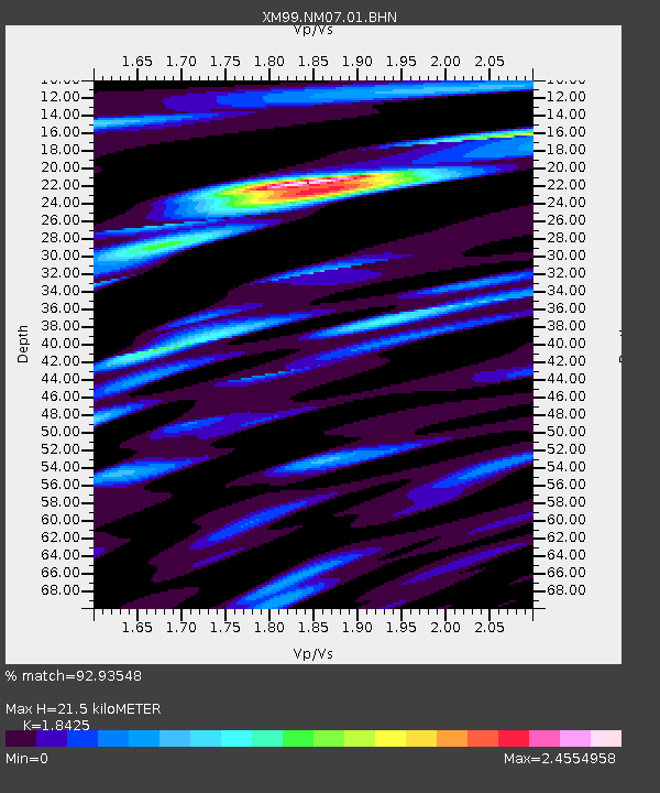
| Estimated Moho Depth: |
21.5 km |
| Estimated Crust Vp/Vs: |
1.84 |
| Assumed Crust Vp: |
6.129 km/s |
| Estimated Crust Vs: |
3.326 km/s |
| Estimated Crust Poisson's Ratio: |
0.29 |
|
| Radial Match: |
92.93548 % |
| Radial Bump: |
400 |
| Transverse Match: |
84.723656 % |
| Transverse Bump: |
400 |
| SOD ConfigId: |
27569 |
| Insert Time: |
2010-02-26 17:22:43.188 +0000 |
| GWidth: |
2.5 |
| Max Bumps: |
400 |
| Tol: |
0.001 |
|
Signal To Noise
| Channel | StoN | STA | LTA |
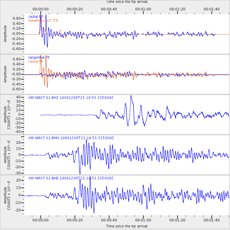
| XM:NM07:01:BHN:19991206T23:19:53.335009Z | 4.7074313 | 1.5889074E-6 | 3.3753173E-7 |
| XM:NM07:01:BHE:19991206T23:19:53.335009Z | 5.037982 | 1.275842E-6 | 2.5324465E-7 |
| XM:NM07:01:BHZ:19991206T23:19:53.335009Z | 9.811557 | 3.5476962E-6 | 3.6158343E-7 |
| Arrivals |
| Ps | 3.1 SECOND |
| PpPs | 9.4 SECOND |
| PsPs/PpSs | 13 SECOND |


