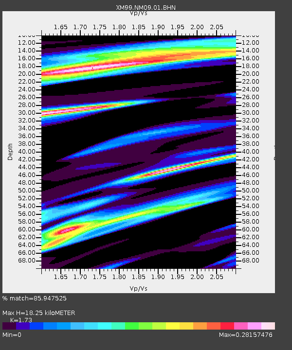
NM09 NewMexico09 - Earthquake Result Viewer
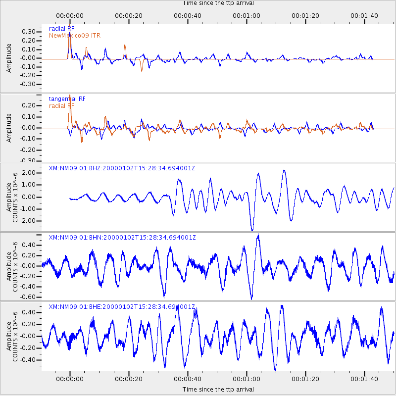
Earthquake location: Tonga Islands
Earthquake latitude/longitude: -20.8/-174.2
Earthquake time(UTC): 2000/01/02 (002) 15:16:32 GMT
Earthquake Depth: 33 km
Earthquake Magnitude: 5.5 MB, 5.8 MS, 5.8 MW, 5.8 MW
Earthquake Catalog/Contributor: WHDF/NEIC
Network: XM Rio Grande Seismic Transect
Station: NM09 NewMexico09
Lat/Lon: 32.33 N/104.12 W
Elevation: 893 m
Distance: 85.3 deg
Az: 53.02 deg
Baz: 242.003 deg
Ray Param: 0.044815205
Estimated Moho Depth: 18.25 km
Estimated Crust Vp/Vs: 1.73
Assumed Crust Vp: 6.232 km/s
Estimated Crust Vs: 3.602 km/s
Estimated Crust Poisson's Ratio: 0.25
Radial Match: 85.947525 %
Radial Bump: 400
Transverse Match: 70.38191 %
Transverse Bump: 378
SOD ConfigId: 27569
Insert Time: 2010-02-26 17:22:49.482 +0000
GWidth: 2.5
Max Bumps: 400
Tol: 0.001

Signal To Noise

ChannelStoNSTALTA
XM:NM09:01:BHN:20000102T15:28:34.694001Z0.98765281.0662997E-71.0796301E-7
XM:NM09:01:BHE:20000102T15:28:34.694001Z0.87189518.9724175E-81.0290708E-7
XM:NM09:01:BHZ:20000102T15:28:34.694001Z1.59563283.3775166E-72.1167254E-7
Arrivals
Ps2.2 SECOND
PpPs7.8 SECOND
PsPs/PpSs10 SECOND