
Station XM NM09 - NewMexico09
Network: XM99 - Rio Grande Seismic Transect
Nearby stations (2 deg radius)
| Station | Name | (Lat, Lon) | Start / End | Elevation |
| NM09 | NewMexico09 | (32.33, -104.12) | 1999-09-11 / 2001-12-31 | 893 m |
| Crust2 Type: | P2,orogen/38km, Alps and Foreland, 2 km seds. |
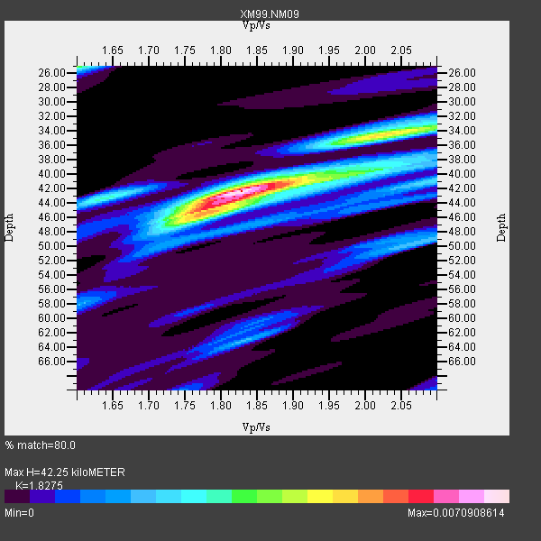
| Thickness Estimate: | 42 km |
| Thickness StdDev: | 4.9 km |
| Vp/Vs Estimate: | 1.83 |
| Vp/Vs StdDev: | 0.13 |
| Vs Estimate: | 3.41 km/s |
| Poisson's Ratio: | 0.29 |
| Peak Value: | 0.01 |
| Assumed Vp: | 6.232 km/s |
| Ps Weight: | 0.33333334 |
| PpPs Weight: | 0.33333334 |
| PsPs Weight: | 0.33333328 |
| Residual Complexity: | 0.578 |
| Nearby stations H: | +- |
| (2.0 deg) Vp/Vs: | +- |
4 with match > 90% ( 30.76923 %) and 11 with match > 80% ( 84.61539 %) out of 13.
Download stack as xyz text file.
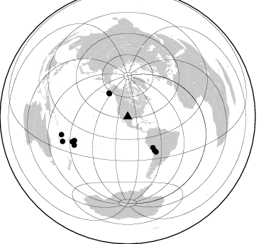
Azimuth Distribution of Events:
Prior Results for this Station
| Study | Thickness | Vp/Vs | Vp | Vs | Poissons Ratio | Extra |
| EARS | 42 km | 1.83 | 6.232 km/s | 3.41 km/s | 0.29 | |
| Crust2.0 | 38 km | 1.76 | 6.232 km/s | 3.534 km/s | 0.26 | P2,orogen/38km, Alps and Foreland, 2 km seds. |
| Wilson | 41 km | 1.74 | 6.21 km/s | 3.569 km/s | 0.25 | |
| Global Maxima | 42 km | 1.83 | 6.232 km/s | 3.41 km/s | 0.29 | amp=0.0070908614 |
| Local Maxima 1 | 45 km | 1.77 | 6.232 km/s | 3.526 km/s | 0.26 | amp=0.0043069385 |
| Local Maxima 2 | 34 km | 2.04 | 6.232 km/s | 3.055 km/s | 0.34 | amp=0.0037195927 |
| Local Maxima 3 | 25 km | 1.60 | 6.232 km/s | 3.895 km/s | 0.18 | amp=0.0035526322 |
| Local Maxima 4 | 43 km | 1.64 | 6.232 km/s | 3.806 km/s | 0.20 | amp=0.0028059215 |
| Predicted Arrivals for vertical incidence (zero ray parameter) | |
| Ps | 5.61 SECOND |
| PpPs | 19.17 SECOND |
| PsPs/PpSs | 24.78 SECOND |
Events Processed for this Station
Download zip of receiver functions as SAC
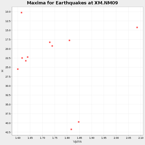
Plot maxima for each earthquake.
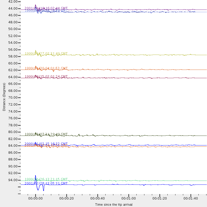
Events Used in the Stack
(11 events)| Radial Match | Distance | Baz | FERegion | Time | Lat/Lon | Depth | Magnitude |
| 97.21945 | 42.3 deg | 321.728 deg | Kodiak Island Region, Alaska | 1999/12/06 23:12:33 GMT | (57.4, -154.5) | 66 km | 6.8 MB, 7.0 MW, 7.0 ML |
| 94.62312 | 96.7 deg | 254.903 deg | Vanuatu Islands | 1999/11/26 13:21:15 GMT | (-16.4, 168.2) | 33 km | 6.4 MB, 7.3 MS, 7.5 MW, 7.3 MW |
| 94.45588 | 98.1 deg | 249.19 deg | Southeast Of Loyalty Islands | 2001/02/28 13:05:31 GMT | (-22.0, 170.1) | 10 km | 5.8 MB, 6.1 MS, 6.2 MW |
| 91.687126 | 63.6 deg | 141.268 deg | Southern Bolivia | 1999/09/15 03:01:24 GMT | (-20.9, -67.3) | 218 km | 6.0 MB, 6.4 MW, 6.4 MW |
| 88.83353 | 41.5 deg | 321.506 deg | Kodiak Island Region, Alaska | 2001/01/10 16:02:44 GMT | (57.1, -153.2) | 33 km | 6.2 MB, 6.8 MS, 7.1 MW, 6.8 ML |
| 88.77504 | 42.3 deg | 321.649 deg | Kodiak Island Region, Alaska | 1999/12/07 00:19:49 GMT | (57.4, -154.5) | 41 km | 6.5 MB, 6.1 MS, 6.4 MW, 6.3 ML |
| 88.46463 | 82.2 deg | 245.751 deg | Tonga Islands | 1999/12/07 21:29:49 GMT | (-15.9, -174.0) | 138 km | 6.2 MB, 6.4 MW, 6.4 MW |
| 86.07184 | 60.9 deg | 141.655 deg | Northern Chile | 1999/11/30 04:01:53 GMT | (-18.9, -69.2) | 128 km | 6.2 MB, 6.6 MW, 6.5 MW |
| 85.947525 | 85.3 deg | 242.003 deg | Tonga Islands | 2000/01/02 15:16:32 GMT | (-20.8, -174.2) | 33 km | 5.5 MB, 5.8 MS, 5.8 MW, 5.8 MW |
| 84.93911 | 85.8 deg | 245.694 deg | Fiji Islands Region | 2001/04/28 04:49:53 GMT | (-18.1, -176.9) | 352 km | 6.2 MB, 6.8 MW, 6.8 MW |
| 81.4721 | 56.2 deg | 140.819 deg | Central Peru | 1999/11/27 02:31:49 GMT | (-14.5, -71.3) | 126 km | 5.8 MB, 5.9 MW, 5.9 MW |
Losers
(2 events)| Radial Match | Distance | Baz | FERegion | Time | Lat/Lon | Depth | Magnitude | Reason |
| 98.17013 | 95.4 deg | 300.53 deg | Volcano Islands, Japan Region | 2000/03/28 11:00:22 GMT | (22.3, 143.7) | 126 km | 6.8 MB, 7.6 MS, 7.6 MW, 7.6 MW | |
| 85.42451 | 95.7 deg | 259.895 deg | Santa Cruz Islands | 2001/01/19 08:10:14 GMT | (-11.7, 166.4) | 50 km | 5.7 MB, 6.1 MS, 6.4 MW, 6.3 MW |
