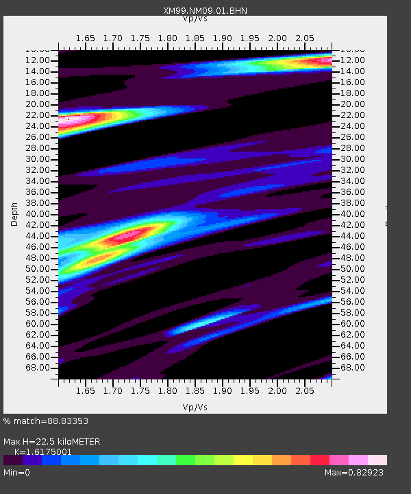
NM09 NewMexico09 - Earthquake Result Viewer
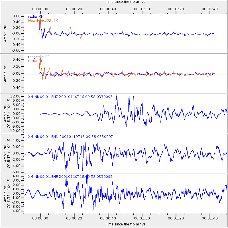
Earthquake location: Kodiak Island Region, Alaska
Earthquake latitude/longitude: 57.1/-153.2
Earthquake time(UTC): 2001/01/10 (010) 16:02:44 GMT
Earthquake Depth: 33 km
Earthquake Magnitude: 6.2 MB, 6.8 MS, 7.1 MW, 6.8 ML
Earthquake Catalog/Contributor: WHDF/NEIC
Network: XM Rio Grande Seismic Transect
Station: NM09 NewMexico09
Lat/Lon: 32.33 N/104.12 W
Elevation: 893 m
Distance: 41.5 deg
Az: 105.2 deg
Baz: 321.506 deg
Ray Param: 0.0736648
Estimated Moho Depth: 22.5 km
Estimated Crust Vp/Vs: 1.62
Assumed Crust Vp: 6.232 km/s
Estimated Crust Vs: 3.853 km/s
Estimated Crust Poisson's Ratio: 0.19
Radial Match: 88.83353 %
Radial Bump: 314
Transverse Match: 64.174484 %
Transverse Bump: 400
SOD ConfigId: 16820
Insert Time: 2010-02-26 17:22:50.640 +0000
GWidth: 2.5
Max Bumps: 400
Tol: 0.001

Signal To Noise

ChannelStoNSTALTA
XM:NM09:01:BHN:20010110T16:09:58.033009Z1.44160025.862145E-74.0664153E-7
XM:NM09:01:BHE:20010110T16:09:58.033009Z1.11313434.5350845E-74.0741577E-7
XM:NM09:01:BHZ:20010110T16:09:58.033009Z4.00106951.7703071E-64.424585E-7
Arrivals
Ps2.4 SECOND
PpPs8.8 SECOND
PsPs/PpSs11 SECOND