You are here: Home > Network List > XM99 - Rio Grande Seismic Transect Stations List
> Station NM09 NewMexico09 > Earthquake Result Viewer
NM09 NewMexico09 - Earthquake Result Viewer
| Earthquake location: |
Southeast Of Loyalty Islands |
| Earthquake latitude/longitude: |
-22.0/170.1 |
| Earthquake time(UTC): |
2001/02/28 (059) 13:05:31 GMT |
| Earthquake Depth: |
10 km |
| Earthquake Magnitude: |
5.8 MB, 6.1 MS, 6.2 MW |
| Earthquake Catalog/Contributor: |
WHDF/NEIC |
|
| Network: |
XM Rio Grande Seismic Transect |
| Station: |
NM09 NewMexico09 |
| Lat/Lon: |
32.33 N/104.12 W |
| Elevation: |
893 m |
|
| Distance: |
98.1 deg |
| Az: |
58.514 deg |
| Baz: |
249.19 deg |
| Ray Param: |
0.040019512 |
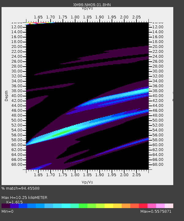
| Estimated Moho Depth: |
10.25 km |
| Estimated Crust Vp/Vs: |
1.62 |
| Assumed Crust Vp: |
6.232 km/s |
| Estimated Crust Vs: |
3.859 km/s |
| Estimated Crust Poisson's Ratio: |
0.19 |
|
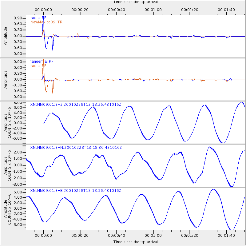
| Radial Match: |
94.45588 % |
| Radial Bump: |
400 |
| Transverse Match: |
78.30648 % |
| Transverse Bump: |
400 |
| SOD ConfigId: |
3744 |
| Insert Time: |
2010-02-26 17:22:51.667 +0000 |
| GWidth: |
2.5 |
| Max Bumps: |
400 |
| Tol: |
0.001 |
|
Signal To Noise
| Channel | StoN | STA | LTA |
| XM:NM09:01:BHN:20010228T13:18:36.431016Z | 1.7898743 | 1.0505173E-6 | 5.869224E-7 |
| XM:NM09:01:BHE:20010228T13:18:36.431016Z | 1.70737 | 4.8737675E-6 | 2.8545467E-6 |
| XM:NM09:01:BHZ:20010228T13:18:36.431016Z | 0.98654354 | 3.3211043E-6 | 3.3664041E-6 |
| Arrivals |
| Ps | 1.0 SECOND |
| PpPs | 4.2 SECOND |
| PsPs/PpSs | 5.2 SECOND |


