You are here: Home > Network List > XM99 - Rio Grande Seismic Transect Stations List
> Station NM09 NewMexico09 > Earthquake Result Viewer
NM09 NewMexico09 - Earthquake Result Viewer
| Earthquake location: |
Fiji Islands Region |
| Earthquake latitude/longitude: |
-18.1/-176.9 |
| Earthquake time(UTC): |
2001/04/28 (118) 04:49:53 GMT |
| Earthquake Depth: |
352 km |
| Earthquake Magnitude: |
6.2 MB, 6.8 MW, 6.8 MW |
| Earthquake Catalog/Contributor: |
WHDF/NEIC |
|
| Network: |
XM Rio Grande Seismic Transect |
| Station: |
NM09 NewMexico09 |
| Lat/Lon: |
32.33 N/104.12 W |
| Elevation: |
893 m |
|
| Distance: |
85.8 deg |
| Az: |
54.2 deg |
| Baz: |
245.694 deg |
| Ray Param: |
0.043631304 |
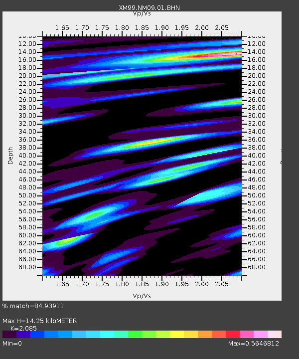
| Estimated Moho Depth: |
14.25 km |
| Estimated Crust Vp/Vs: |
2.09 |
| Assumed Crust Vp: |
6.232 km/s |
| Estimated Crust Vs: |
2.989 km/s |
| Estimated Crust Poisson's Ratio: |
0.35 |
|
| Radial Match: |
84.93911 % |
| Radial Bump: |
400 |
| Transverse Match: |
70.43128 % |
| Transverse Bump: |
400 |
| SOD ConfigId: |
4714 |
| Insert Time: |
2010-02-26 17:22:53.250 +0000 |
| GWidth: |
2.5 |
| Max Bumps: |
400 |
| Tol: |
0.001 |
|
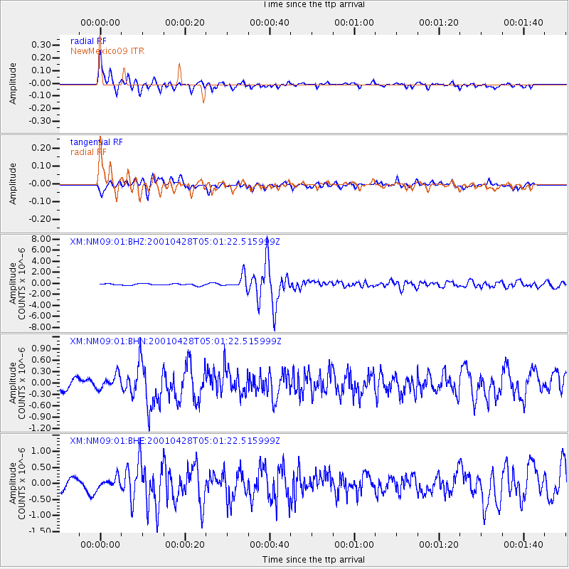
Signal To Noise
| Channel | StoN | STA | LTA |
| XM:NM09:01:BHN:20010428T05:01:22.515999Z | 1.6667163 | 1.9506648E-7 | 1.170364E-7 |
| XM:NM09:01:BHE:20010428T05:01:22.515999Z | 1.2680286 | 1.5568334E-7 | 1.2277589E-7 |
| XM:NM09:01:BHZ:20010428T05:01:22.515999Z | 8.245907 | 1.2463305E-6 | 1.5114537E-7 |
| Arrivals |
| Ps | 2.5 SECOND |
| PpPs | 6.9 SECOND |
| PsPs/PpSs | 9.5 SECOND |


