You are here: Home > Network List > XM99 - Rio Grande Seismic Transect Stations List
> Station NM09 NewMexico09 > Earthquake Result Viewer
NM09 NewMexico09 - Earthquake Result Viewer
| Earthquake location: |
Southern Bolivia |
| Earthquake latitude/longitude: |
-20.9/-67.3 |
| Earthquake time(UTC): |
1999/09/15 (258) 03:01:24 GMT |
| Earthquake Depth: |
218 km |
| Earthquake Magnitude: |
6.0 MB, 6.4 MW, 6.4 MW |
| Earthquake Catalog/Contributor: |
WHDF/NEIC |
|
| Network: |
XM Rio Grande Seismic Transect |
| Station: |
NM09 NewMexico09 |
| Lat/Lon: |
32.33 N/104.12 W |
| Elevation: |
893 m |
|
| Distance: |
63.6 deg |
| Az: |
325.481 deg |
| Baz: |
141.268 deg |
| Ray Param: |
0.058788802 |
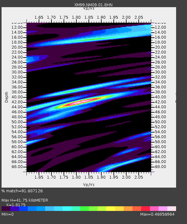
| Estimated Moho Depth: |
41.75 km |
| Estimated Crust Vp/Vs: |
1.82 |
| Assumed Crust Vp: |
6.232 km/s |
| Estimated Crust Vs: |
3.429 km/s |
| Estimated Crust Poisson's Ratio: |
0.28 |
|
| Radial Match: |
91.687126 % |
| Radial Bump: |
400 |
| Transverse Match: |
87.41866 % |
| Transverse Bump: |
400 |
| SOD ConfigId: |
27569 |
| Insert Time: |
2010-02-26 17:22:58.108 +0000 |
| GWidth: |
2.5 |
| Max Bumps: |
400 |
| Tol: |
0.001 |
|
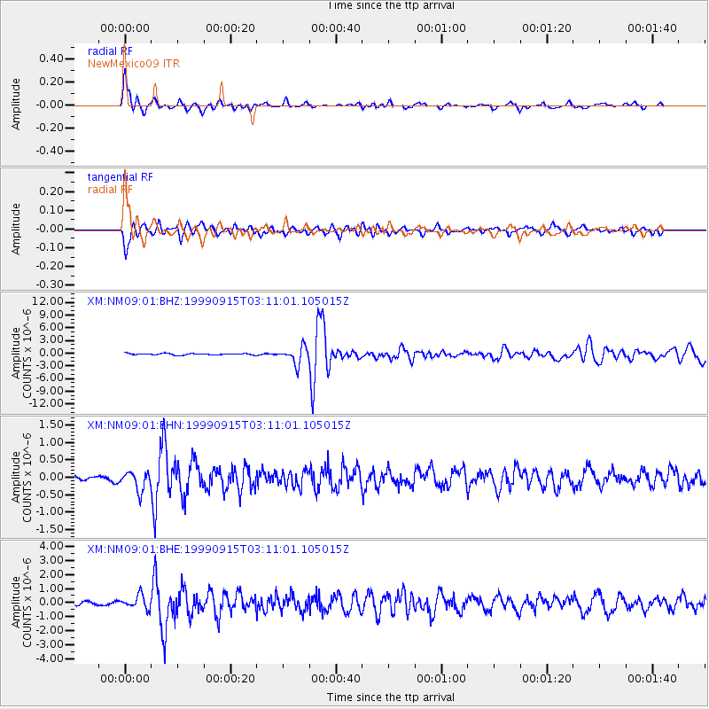
Signal To Noise
| Channel | StoN | STA | LTA |
| XM:NM09:01:BHN:19990915T03:11:01.105015Z | 4.2316065 | 2.7761078E-7 | 6.560411E-8 |
| XM:NM09:01:BHE:19990915T03:11:01.105015Z | 2.9631596 | 4.78743E-7 | 1.6156504E-7 |
| XM:NM09:01:BHZ:19990915T03:11:01.105015Z | 10.979759 | 2.0057807E-6 | 1.8267984E-7 |
| Arrivals |
| Ps | 5.7 SECOND |
| PpPs | 18 SECOND |
| PsPs/PpSs | 24 SECOND |


