You are here: Home > Network List > XM99 - Rio Grande Seismic Transect Stations List
> Station NM09 NewMexico09 > Earthquake Result Viewer
NM09 NewMexico09 - Earthquake Result Viewer
| Earthquake location: |
Kodiak Island Region, Alaska |
| Earthquake latitude/longitude: |
57.4/-154.5 |
| Earthquake time(UTC): |
1999/12/06 (340) 23:12:33 GMT |
| Earthquake Depth: |
66 km |
| Earthquake Magnitude: |
6.8 MB, 7.0 MW, 7.0 ML |
| Earthquake Catalog/Contributor: |
WHDF/NEIC |
|
| Network: |
XM Rio Grande Seismic Transect |
| Station: |
NM09 NewMexico09 |
| Lat/Lon: |
32.33 N/104.12 W |
| Elevation: |
893 m |
|
| Distance: |
42.3 deg |
| Az: |
104.292 deg |
| Baz: |
321.728 deg |
| Ray Param: |
0.07307415 |
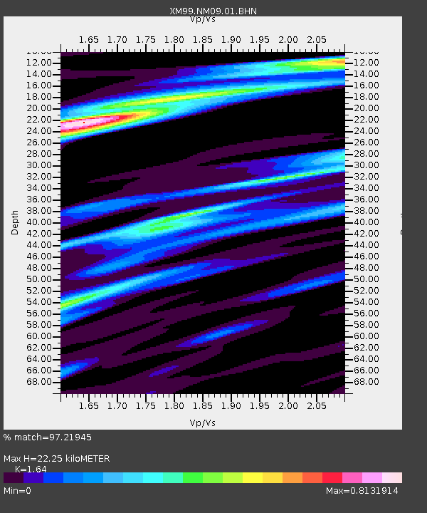
| Estimated Moho Depth: |
22.25 km |
| Estimated Crust Vp/Vs: |
1.64 |
| Assumed Crust Vp: |
6.232 km/s |
| Estimated Crust Vs: |
3.8 km/s |
| Estimated Crust Poisson's Ratio: |
0.20 |
|
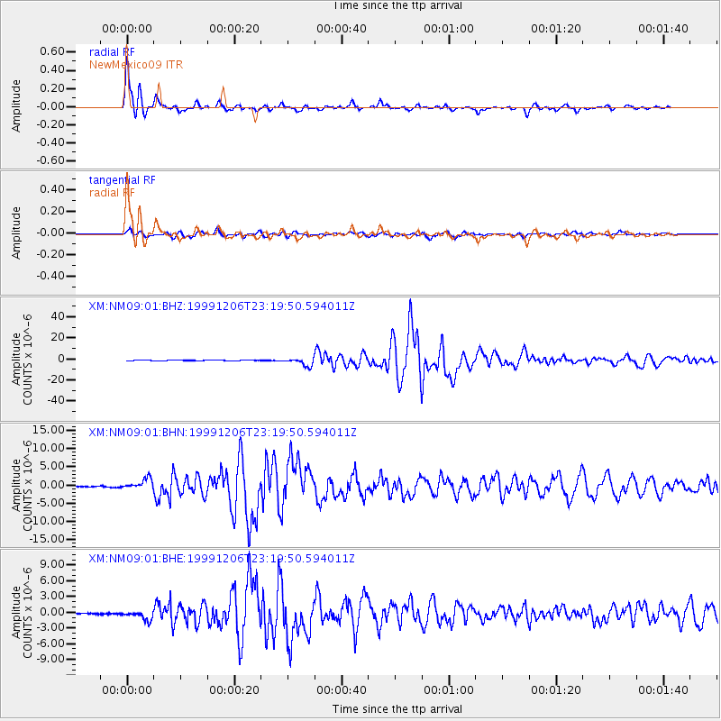
| Radial Match: |
97.21945 % |
| Radial Bump: |
381 |
| Transverse Match: |
92.858696 % |
| Transverse Bump: |
400 |
| SOD ConfigId: |
27569 |
| Insert Time: |
2010-02-26 17:23:00.932 +0000 |
| GWidth: |
2.5 |
| Max Bumps: |
400 |
| Tol: |
0.001 |
|
Signal To Noise
| Channel | StoN | STA | LTA |
| XM:NM09:01:BHN:19991206T23:19:50.594011Z | 8.494615 | 1.4929836E-6 | 1.7575648E-7 |
| XM:NM09:01:BHE:19991206T23:19:50.594011Z | 5.8563576 | 8.7709117E-7 | 1.4976736E-7 |
| XM:NM09:01:BHZ:19991206T23:19:50.594011Z | 12.807608 | 3.7926145E-6 | 2.96122E-7 |
| Arrivals |
| Ps | 2.4 SECOND |
| PpPs | 8.8 SECOND |
| PsPs/PpSs | 11 SECOND |


