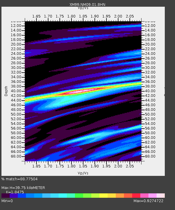
NM09 NewMexico09 - Earthquake Result Viewer
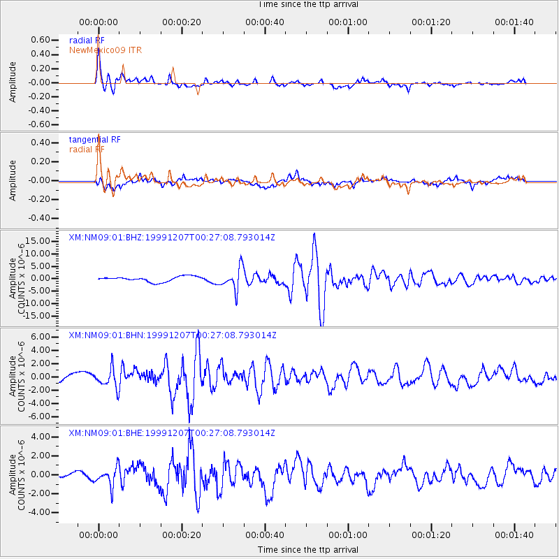
Earthquake location: Kodiak Island Region, Alaska
Earthquake latitude/longitude: 57.4/-154.5
Earthquake time(UTC): 1999/12/07 (341) 00:19:49 GMT
Earthquake Depth: 41 km
Earthquake Magnitude: 6.5 MB, 6.1 MS, 6.4 MW, 6.3 ML
Earthquake Catalog/Contributor: WHDF/NEIC
Network: XM Rio Grande Seismic Transect
Station: NM09 NewMexico09
Lat/Lon: 32.33 N/104.12 W
Elevation: 893 m
Distance: 42.3 deg
Az: 104.213 deg
Baz: 321.649 deg
Ray Param: 0.07316996
Estimated Moho Depth: 39.75 km
Estimated Crust Vp/Vs: 1.85
Assumed Crust Vp: 6.232 km/s
Estimated Crust Vs: 3.373 km/s
Estimated Crust Poisson's Ratio: 0.29
Radial Match: 88.77504 %
Radial Bump: 400
Transverse Match: 79.35063 %
Transverse Bump: 400
SOD ConfigId: 27569
Insert Time: 2010-02-26 17:23:02.036 +0000
GWidth: 2.5
Max Bumps: 400
Tol: 0.001

Signal To Noise

ChannelStoNSTALTA
XM:NM09:01:BHN:19991207T00:27:08.793014Z2.47755171.4930946E-66.026492E-7
XM:NM09:01:BHE:19991207T00:27:08.793014Z1.17445779.716149E-78.2728815E-7
XM:NM09:01:BHZ:19991207T00:27:08.793014Z4.45220574.6115597E-61.0357921E-6
Arrivals
Ps5.7 SECOND
PpPs17 SECOND
PsPs/PpSs23 SECOND