You are here: Home > Network List > XM99 - Rio Grande Seismic Transect Stations List
> Station NM09 NewMexico09 > Earthquake Result Viewer
NM09 NewMexico09 - Earthquake Result Viewer
| Earthquake location: |
Tonga Islands |
| Earthquake latitude/longitude: |
-15.9/-174.0 |
| Earthquake time(UTC): |
1999/12/07 (341) 21:29:49 GMT |
| Earthquake Depth: |
138 km |
| Earthquake Magnitude: |
6.2 MB, 6.4 MW, 6.4 MW |
| Earthquake Catalog/Contributor: |
WHDF/NEIC |
|
| Network: |
XM Rio Grande Seismic Transect |
| Station: |
NM09 NewMexico09 |
| Lat/Lon: |
32.33 N/104.12 W |
| Elevation: |
893 m |
|
| Distance: |
82.2 deg |
| Az: |
53.349 deg |
| Baz: |
245.751 deg |
| Ray Param: |
0.046724483 |
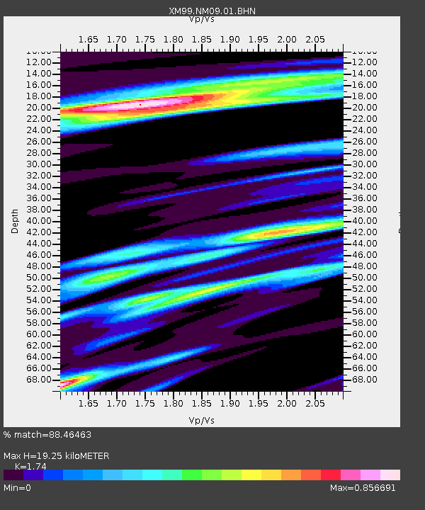
| Estimated Moho Depth: |
19.25 km |
| Estimated Crust Vp/Vs: |
1.74 |
| Assumed Crust Vp: |
6.232 km/s |
| Estimated Crust Vs: |
3.581 km/s |
| Estimated Crust Poisson's Ratio: |
0.25 |
|
| Radial Match: |
88.46463 % |
| Radial Bump: |
365 |
| Transverse Match: |
53.64634 % |
| Transverse Bump: |
400 |
| SOD ConfigId: |
27569 |
| Insert Time: |
2010-02-26 17:23:03.213 +0000 |
| GWidth: |
2.5 |
| Max Bumps: |
400 |
| Tol: |
0.001 |
|
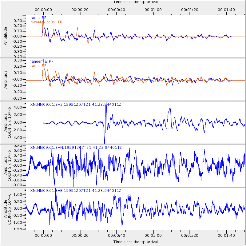
Signal To Noise
| Channel | StoN | STA | LTA |
| XM:NM09:01:BHN:19991207T21:41:23.944011Z | 1.0091761 | 2.2343811E-7 | 2.2140645E-7 |
| XM:NM09:01:BHE:19991207T21:41:23.944011Z | 1.5911092 | 2.7918293E-7 | 1.7546435E-7 |
| XM:NM09:01:BHZ:19991207T21:41:23.944011Z | 8.392201 | 2.0947766E-6 | 2.496099E-7 |
| Arrivals |
| Ps | 2.3 SECOND |
| PpPs | 8.3 SECOND |
| PsPs/PpSs | 11 SECOND |


