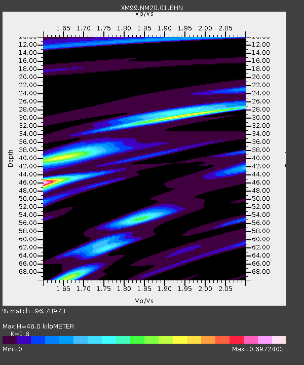
NM20 NewMexico20 - Earthquake Result Viewer
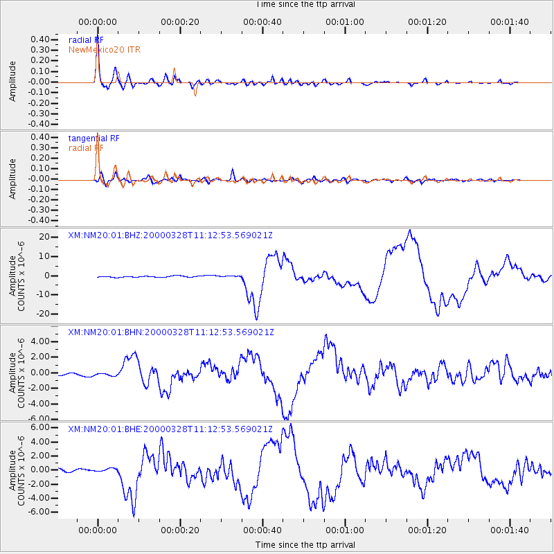
Earthquake location: Volcano Islands, Japan Region
Earthquake latitude/longitude: 22.3/143.7
Earthquake time(UTC): 2000/03/28 (088) 11:00:22 GMT
Earthquake Depth: 126 km
Earthquake Magnitude: 6.8 MB, 7.6 MS, 7.6 MW, 7.6 MW
Earthquake Catalog/Contributor: WHDF/NEIC
Network: XM Rio Grande Seismic Transect
Station: NM20 NewMexico20
Lat/Lon: 33.60 N/105.59 W
Elevation: 2034 m
Distance: 93.7 deg
Az: 51.487 deg
Baz: 299.769 deg
Ray Param: 0.041130964
Estimated Moho Depth: 46.0 km
Estimated Crust Vp/Vs: 1.60
Assumed Crust Vp: 6.232 km/s
Estimated Crust Vs: 3.895 km/s
Estimated Crust Poisson's Ratio: 0.18
Radial Match: 96.78973 %
Radial Bump: 400
Transverse Match: 90.34739 %
Transverse Bump: 400
SOD ConfigId: 27569
Insert Time: 2010-02-26 17:23:06.793 +0000
GWidth: 2.5
Max Bumps: 400
Tol: 0.001

Signal To Noise

ChannelStoNSTALTA
XM:NM20:01:BHN:20000328T11:12:53.569021Z0.63750261.42519E-72.235583E-7
XM:NM20:01:BHE:20000328T11:12:53.569021Z1.17817162.5299616E-72.1473626E-7
XM:NM20:01:BHZ:20000328T11:12:53.569021Z0.90648362.756094E-73.0404235E-7
Arrivals
Ps4.5 SECOND
PpPs19 SECOND
PsPs/PpSs23 SECOND