
Station XM NM20 - NewMexico20
Network: XM99 - Rio Grande Seismic Transect
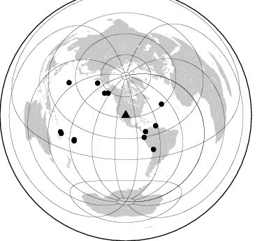
Nearby stations (2 deg radius)
| Station | Name | (Lat, Lon) | Start / End | Elevation |
| NM20 | NewMexico20 | (33.60, -105.59) | 1999-09-16 / 2001-12-31 | 2034 m |
| Crust2 Type: | P2,orogen/38km, Alps and Foreland, 2 km seds. |
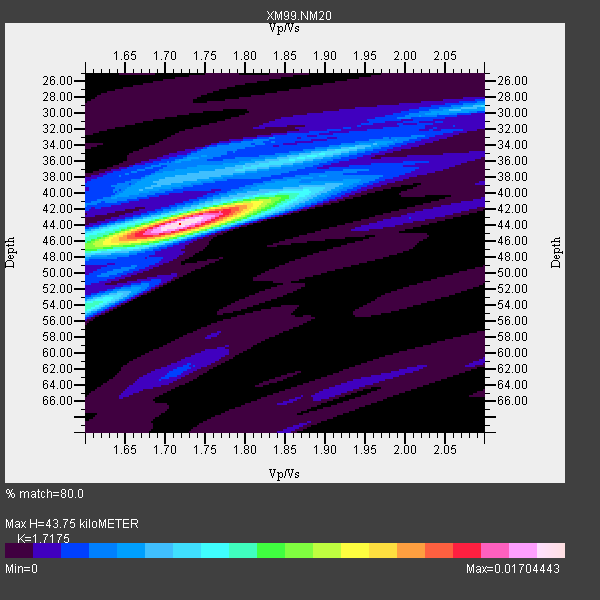
| Thickness Estimate: | 44 km |
| Thickness StdDev: | 2.6 km |
| Vp/Vs Estimate: | 1.72 |
| Vp/Vs StdDev: | 0.06 |
| Vs Estimate: | 3.628 km/s |
| Poisson's Ratio: | 0.24 |
| Peak Value: | 0.02 |
| Assumed Vp: | 6.232 km/s |
| Ps Weight: | 0.33333334 |
| PpPs Weight: | 0.33333334 |
| PsPs Weight: | 0.33333328 |
| Residual Complexity: | 0.528 |
| Nearby stations H: | +- |
| (2.0 deg) Vp/Vs: | +- |
6 with match > 90% ( 40.0 %) and 13 with match > 80% ( 86.666664 %) out of 15.
Download stack as xyz text file.
Azimuth Distribution of Events:
Prior Results for this Station
| Study | Thickness | Vp/Vs | Vp | Vs | Poissons Ratio | Extra |
| EARS | 44 km | 1.72 | 6.232 km/s | 3.628 km/s | 0.24 | |
| Crust2.0 | 38 km | 1.76 | 6.232 km/s | 3.534 km/s | 0.26 | P2,orogen/38km, Alps and Foreland, 2 km seds. |
| Wilson | 42 km | 1.77 | 6.24 km/s | 3.525 km/s | 0.27 | |
| Global Maxima | 44 km | 1.72 | 6.232 km/s | 3.628 km/s | 0.24 | amp=0.01704443 |
| Local Maxima 1 | 41 km | 1.80 | 6.232 km/s | 3.472 km/s | 0.27 | amp=0.007239096 |
| Local Maxima 2 | 54 km | 1.60 | 6.232 km/s | 3.895 km/s | 0.18 | amp=0.006893411 |
| Local Maxima 3 | 46 km | 1.68 | 6.232 km/s | 3.72 km/s | 0.22 | amp=0.0058095446 |
| Local Maxima 4 | 38 km | 1.71 | 6.232 km/s | 3.65 km/s | 0.24 | amp=0.0044854092 |
| Predicted Arrivals for vertical incidence (zero ray parameter) | |
| Ps | 5.04 SECOND |
| PpPs | 19.08 SECOND |
| PsPs/PpSs | 24.12 SECOND |
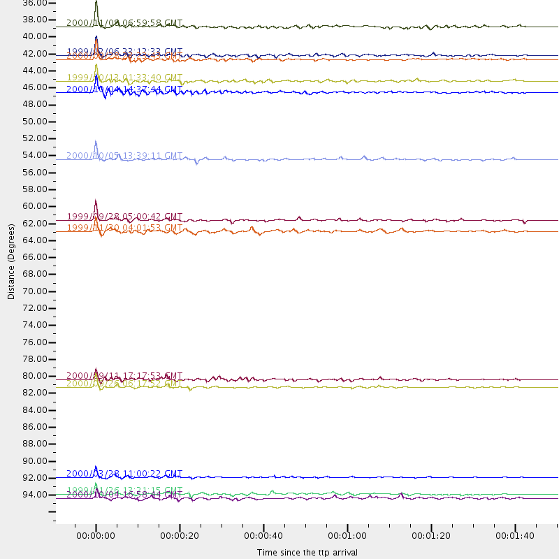
Events Processed for this Station
Download zip of receiver functions as SAC
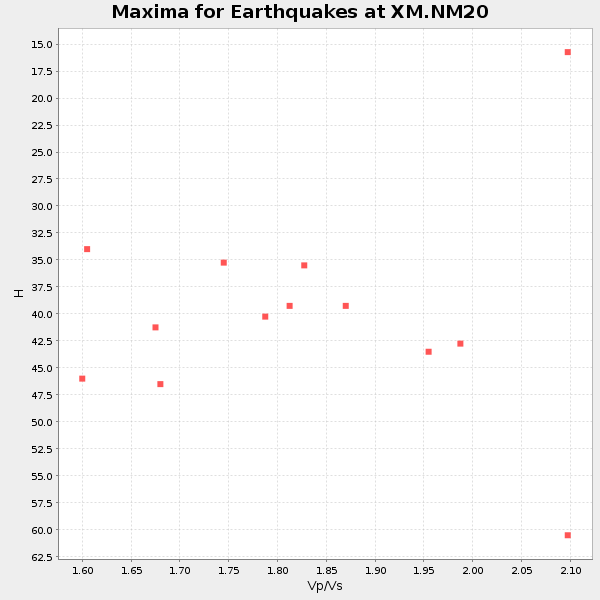
Plot maxima for each earthquake.
Events Used in the Stack
(13 events)| Radial Match | Distance | Baz | FERegion | Time | Lat/Lon | Depth | Magnitude |
| 96.78973 | 93.7 deg | 299.769 deg | Volcano Islands, Japan Region | 2000/03/28 11:00:22 GMT | (22.3, 143.7) | 126 km | 6.8 MB, 7.6 MS, 7.6 MW, 7.6 MW |
| 96.16335 | 40.5 deg | 321.127 deg | Kodiak Island Region, Alaska | 1999/12/06 23:12:33 GMT | (57.4, -154.5) | 66 km | 6.8 MB, 7.0 MW, 7.0 ML |
| 95.33189 | 45.2 deg | 109.35 deg | Windward Islands | 2000/10/04 14:37:44 GMT | (11.1, -62.6) | 110 km | 5.6 MB, 5.4 MS, 6.1 MW, 5.9 MD |
| 94.965294 | 41.0 deg | 139.914 deg | Near Coast Of Ecuador | 2000/09/28 23:23:43 GMT | (-0.2, -80.6) | 23 km | 5.8 MB, 6.0 MS, 6.6 MW, 6.4 MW |
| 94.301414 | 82.4 deg | 243.683 deg | Tonga Islands | 2000/09/26 06:17:52 GMT | (-17.2, -173.9) | 56 km | 6.1 MB, 6.1 MS, 6.4 MW, 6.1 ME |
| 92.81714 | 43.8 deg | 316.111 deg | Alaska Peninsula | 1999/10/13 01:33:40 GMT | (54.7, -161.2) | 30 km | 6.0 MB, 6.2 MS, 6.5 MW, 6.0 ML |
| 89.22994 | 95.8 deg | 254.275 deg | Vanuatu Islands | 1999/11/26 13:21:15 GMT | (-16.4, 168.2) | 33 km | 6.4 MB, 7.3 MS, 7.5 MW, 7.3 MW |
| 88.2435 | 36.9 deg | 129.577 deg | Panama-Colombia Border Region | 2000/11/08 06:59:58 GMT | (7.0, -77.8) | 17 km | 6.0 MB, 6.4 MS, 6.5 MW, 6.2 ML |
| 87.40567 | 53.6 deg | 72.977 deg | Northern Mid-Atlantic Ridge | 2000/10/05 13:39:11 GMT | (31.7, -41.0) | 10 km | 5.4 MB, 6.1 MS, 6.0 MW, 5.9 MW |
| 84.983185 | 62.7 deg | 140.766 deg | Northern Chile | 1999/11/30 04:01:53 GMT | (-18.9, -69.2) | 128 km | 6.2 MB, 6.6 MW, 6.5 MW |
| 84.73714 | 81.4 deg | 244.564 deg | Tonga Islands | 2000/09/11 17:17:53 GMT | (-15.9, -173.7) | 115 km | 6.0 MB, 6.3 MW, 6.3 MW |
| 83.65492 | 96.3 deg | 255.803 deg | Vanuatu Islands | 2000/10/04 16:58:44 GMT | (-15.4, 166.9) | 23 km | 6.1 MB, 6.9 MS, 6.8 MW, 6.5 ME |
| 81.64528 | 61.3 deg | 318.533 deg | Komandorskiye Ostrova Region | 1999/09/28 05:00:42 GMT | (54.6, 168.3) | 33 km | 5.4 MB, 6.1 MS, 6.1 MW, 6.1 MW |
Losers
(2 events)| Radial Match | Distance | Baz | FERegion | Time | Lat/Lon | Depth | Magnitude | Reason |
| 93.56674 | 97.4 deg | 248.613 deg | Southeast Of Loyalty Islands | 2001/02/28 13:05:31 GMT | (-22.0, 170.1) | 10 km | 5.8 MB, 6.1 MS, 6.2 MW | |
| 86.26068 | 94.7 deg | 259.486 deg | Santa Cruz Islands | 2000/06/10 09:17:53 GMT | (-11.4, 166.2) | 33 km | 5.4 MB, 5.6 MS, 5.9 MW, 5.9 MW |
