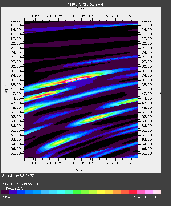
NM20 NewMexico20 - Earthquake Result Viewer
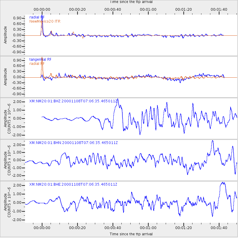
Earthquake location: Panama-Colombia Border Region
Earthquake latitude/longitude: 7.0/-77.8
Earthquake time(UTC): 2000/11/08 (313) 06:59:58 GMT
Earthquake Depth: 17 km
Earthquake Magnitude: 6.0 MB, 6.4 MS, 6.5 MW, 6.2 ML
Earthquake Catalog/Contributor: WHDF/NEIC
Network: XM Rio Grande Seismic Transect
Station: NM20 NewMexico20
Lat/Lon: 33.60 N/105.59 W
Elevation: 2034 m
Distance: 36.9 deg
Az: 319.602 deg
Baz: 129.577 deg
Ray Param: 0.07643303
Estimated Moho Depth: 35.5 km
Estimated Crust Vp/Vs: 1.83
Assumed Crust Vp: 6.232 km/s
Estimated Crust Vs: 3.41 km/s
Estimated Crust Poisson's Ratio: 0.29
Radial Match: 88.2435 %
Radial Bump: 400
Transverse Match: 47.62074 %
Transverse Bump: 400
SOD ConfigId: 16820
Insert Time: 2010-02-26 17:23:10.180 +0000
GWidth: 2.5
Max Bumps: 400
Tol: 0.001

Signal To Noise

ChannelStoNSTALTA
XM:NM20:01:BHN:20001108T07:06:35.465011Z1.54011766.133266E-73.9823362E-7
XM:NM20:01:BHE:20001108T07:06:35.465011Z0.706593041.6008379E-72.2655725E-7
XM:NM20:01:BHZ:20001108T07:06:35.465011Z4.769645.813883E-71.2189352E-7
Arrivals
Ps5.0 SECOND
PpPs15 SECOND
PsPs/PpSs20 SECOND