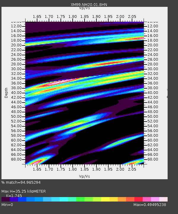
NM20 NewMexico20 - Earthquake Result Viewer

Earthquake location: Near Coast Of Ecuador
Earthquake latitude/longitude: -0.2/-80.6
Earthquake time(UTC): 2000/09/28 (272) 23:23:43 GMT
Earthquake Depth: 23 km
Earthquake Magnitude: 5.8 MB, 6.0 MS, 6.6 MW, 6.4 MW
Earthquake Catalog/Contributor: WHDF/NEIC
Network: XM Rio Grande Seismic Transect
Station: NM20 NewMexico20
Lat/Lon: 33.60 N/105.59 W
Elevation: 2034 m
Distance: 41.0 deg
Az: 327.491 deg
Baz: 139.914 deg
Ray Param: 0.07400569
Estimated Moho Depth: 35.25 km
Estimated Crust Vp/Vs: 1.75
Assumed Crust Vp: 6.232 km/s
Estimated Crust Vs: 3.571 km/s
Estimated Crust Poisson's Ratio: 0.26
Radial Match: 94.965294 %
Radial Bump: 324
Transverse Match: 86.449776 %
Transverse Bump: 400
SOD ConfigId: 16820
Insert Time: 2010-02-26 17:23:13.809 +0000
GWidth: 2.5
Max Bumps: 400
Tol: 0.001

Signal To Noise

ChannelStoNSTALTA
XM:NM20:01:BHN:20000928T23:30:54.105005Z1.92327651.2216216E-76.351774E-8
XM:NM20:01:BHE:20000928T23:30:54.105005Z1.43752491.6190374E-71.12626736E-7
XM:NM20:01:BHZ:20000928T23:30:54.105005Z4.08727171.7659278E-74.320554E-8
Arrivals
Ps4.5 SECOND
PpPs15 SECOND
PsPs/PpSs19 SECOND