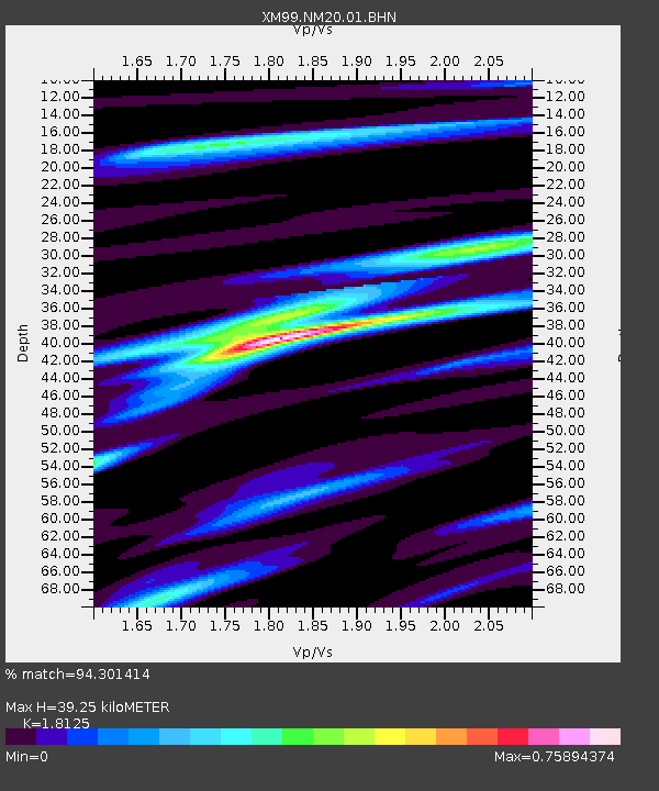
NM20 NewMexico20 - Earthquake Result Viewer
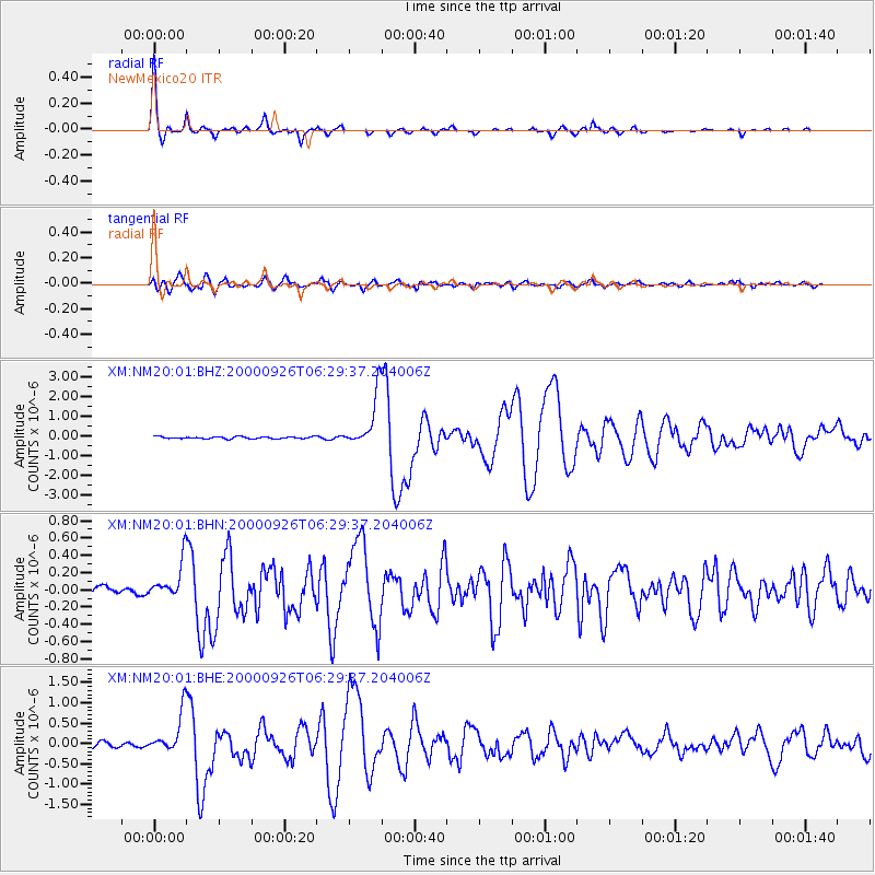
Earthquake location: Tonga Islands
Earthquake latitude/longitude: -17.2/-173.9
Earthquake time(UTC): 2000/09/26 (270) 06:17:52 GMT
Earthquake Depth: 56 km
Earthquake Magnitude: 6.1 MB, 6.1 MS, 6.4 MW, 6.1 ME
Earthquake Catalog/Contributor: WHDF/NEIC
Network: XM Rio Grande Seismic Transect
Station: NM20 NewMexico20
Lat/Lon: 33.60 N/105.59 W
Elevation: 2034 m
Distance: 82.4 deg
Az: 51.495 deg
Baz: 243.683 deg
Ray Param: 0.046835646
Estimated Moho Depth: 39.25 km
Estimated Crust Vp/Vs: 1.81
Assumed Crust Vp: 6.232 km/s
Estimated Crust Vs: 3.438 km/s
Estimated Crust Poisson's Ratio: 0.28
Radial Match: 94.301414 %
Radial Bump: 237
Transverse Match: 82.97518 %
Transverse Bump: 400
SOD ConfigId: 16820
Insert Time: 2010-02-26 17:23:14.918 +0000
GWidth: 2.5
Max Bumps: 400
Tol: 0.001

Signal To Noise

ChannelStoNSTALTA
XM:NM20:01:BHN:20000926T06:29:37.204006Z3.0492682.1134409E-76.930978E-8
XM:NM20:01:BHE:20000926T06:29:37.204006Z6.2508054.96901E-77.949392E-8
XM:NM20:01:BHZ:20000926T06:29:37.204006Z26.97731.3307186E-64.9327348E-8
Arrivals
Ps5.2 SECOND
PpPs17 SECOND
PsPs/PpSs23 SECOND