You are here: Home > Network List > XM99 - Rio Grande Seismic Transect Stations List
> Station NM20 NewMexico20 > Earthquake Result Viewer
NM20 NewMexico20 - Earthquake Result Viewer

| Earthquake location: |
Tonga Islands |
| Earthquake latitude/longitude: |
-15.9/-173.7 |
| Earthquake time(UTC): |
2000/09/11 (255) 17:17:53 GMT |
| Earthquake Depth: |
115 km |
| Earthquake Magnitude: |
6.0 MB, 6.3 MW, 6.3 MW |
| Earthquake Catalog/Contributor: |
WHDF/NEIC |
|
| Network: |
XM Rio Grande Seismic Transect |
| Station: |
NM20 NewMexico20 |
| Lat/Lon: |
33.60 N/105.59 W |
| Elevation: |
2034 m |
|
| Distance: |
81.4 deg |
| Az: |
51.553 deg |
| Baz: |
244.564 deg |
| Ray Param: |
0.04736108 |
| Estimated Moho Depth: |
60.5 km |
| Estimated Crust Vp/Vs: |
2.10 |
| Assumed Crust Vp: |
6.232 km/s |
| Estimated Crust Vs: |
2.971 km/s |
| Estimated Crust Poisson's Ratio: |
0.35 |
|
| Radial Match: |
84.73714 % |
| Radial Bump: |
400 |
| Transverse Match: |
65.771065 % |
| Transverse Bump: |
400 |
| SOD ConfigId: |
16820 |
| Insert Time: |
2010-02-26 17:23:16.039 +0000 |
| GWidth: |
2.5 |
| Max Bumps: |
400 |
| Tol: |
0.001 |
|
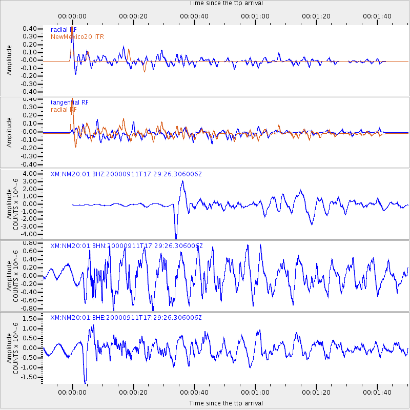
Signal To Noise
| Channel | StoN | STA | LTA |
| XM:NM20:01:BHN:20000911T17:29:26.306006Z | 3.5274112 | 2.6587256E-7 | 7.537328E-8 |
| XM:NM20:01:BHE:20000911T17:29:26.306006Z | 4.266224 | 6.764363E-7 | 1.5855619E-7 |
| XM:NM20:01:BHZ:20000911T17:29:26.306006Z | 14.440556 | 1.5744823E-6 | 1.0903198E-7 |
| Arrivals |
| Ps | 11 SECOND |
| PpPs | 29 SECOND |
| PsPs/PpSs | 40 SECOND |


