You are here: Home > Network List > XM99 - Rio Grande Seismic Transect Stations List
> Station NM20 NewMexico20 > Earthquake Result Viewer
NM20 NewMexico20 - Earthquake Result Viewer
| Earthquake location: |
Kodiak Island Region, Alaska |
| Earthquake latitude/longitude: |
57.4/-154.5 |
| Earthquake time(UTC): |
1999/12/06 (340) 23:12:33 GMT |
| Earthquake Depth: |
66 km |
| Earthquake Magnitude: |
6.8 MB, 7.0 MW, 7.0 ML |
| Earthquake Catalog/Contributor: |
WHDF/NEIC |
|
| Network: |
XM Rio Grande Seismic Transect |
| Station: |
NM20 NewMexico20 |
| Lat/Lon: |
33.60 N/105.59 W |
| Elevation: |
2034 m |
|
| Distance: |
40.5 deg |
| Az: |
104.556 deg |
| Baz: |
321.127 deg |
| Ray Param: |
0.07415671 |
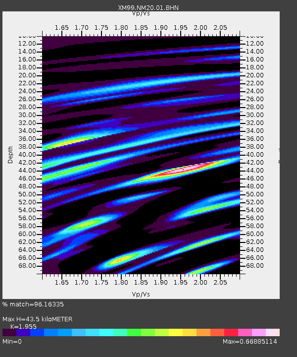
| Estimated Moho Depth: |
43.5 km |
| Estimated Crust Vp/Vs: |
1.96 |
| Assumed Crust Vp: |
6.232 km/s |
| Estimated Crust Vs: |
3.188 km/s |
| Estimated Crust Poisson's Ratio: |
0.32 |
|
| Radial Match: |
96.16335 % |
| Radial Bump: |
354 |
| Transverse Match: |
85.47655 % |
| Transverse Bump: |
400 |
| SOD ConfigId: |
27569 |
| Insert Time: |
2010-02-26 17:23:22.464 +0000 |
| GWidth: |
2.5 |
| Max Bumps: |
400 |
| Tol: |
0.001 |
|

Signal To Noise
| Channel | StoN | STA | LTA |
| XM:NM20:01:BHN:19991206T23:19:36.120012Z | 5.894142 | 1.0684239E-6 | 1.8126876E-7 |
| XM:NM20:01:BHE:19991206T23:19:36.120012Z | 2.6316502 | 8.1741103E-7 | 3.106078E-7 |
| XM:NM20:01:BHZ:19991206T23:19:36.120012Z | 14.45456 | 2.573457E-6 | 1.7803774E-7 |
| Arrivals |
| Ps | 7.1 SECOND |
| PpPs | 19 SECOND |
| PsPs/PpSs | 27 SECOND |


