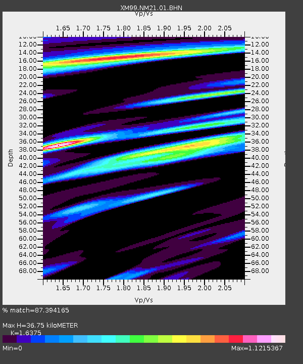
NM21 NewMexico21 - Earthquake Result Viewer
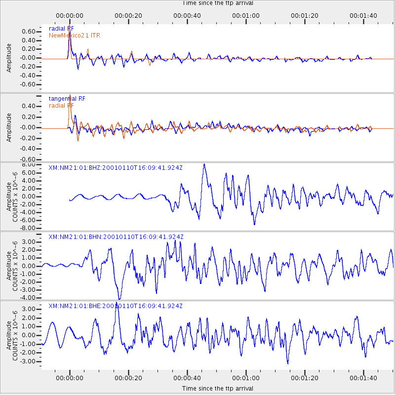
Earthquake location: Kodiak Island Region, Alaska
Earthquake latitude/longitude: 57.1/-153.2
Earthquake time(UTC): 2001/01/10 (010) 16:02:44 GMT
Earthquake Depth: 33 km
Earthquake Magnitude: 6.2 MB, 6.8 MS, 7.1 MW, 6.8 ML
Earthquake Catalog/Contributor: WHDF/NEIC
Network: XM Rio Grande Seismic Transect
Station: NM21 NewMexico21
Lat/Lon: 33.73 N/105.74 W
Elevation: 2000 m
Distance: 39.6 deg
Az: 105.484 deg
Baz: 320.84 deg
Ray Param: 0.074837364
Estimated Moho Depth: 36.75 km
Estimated Crust Vp/Vs: 1.64
Assumed Crust Vp: 6.232 km/s
Estimated Crust Vs: 3.806 km/s
Estimated Crust Poisson's Ratio: 0.20
Radial Match: 87.394165 %
Radial Bump: 400
Transverse Match: 71.53834 %
Transverse Bump: 400
SOD ConfigId: 16820
Insert Time: 2010-02-26 17:23:26.160 +0000
GWidth: 2.5
Max Bumps: 400
Tol: 0.001

Signal To Noise

ChannelStoNSTALTA
XM:NM21:01:BHN:20010110T16:09:41.924Z1.35501286.007934E-74.4338577E-7
XM:NM21:01:BHE:20010110T16:09:41.924Z0.82483626.2519865E-77.579671E-7
XM:NM21:01:BHZ:20010110T16:09:41.924Z2.27056121.0395307E-64.5782986E-7
Arrivals
Ps4.0 SECOND
PpPs14 SECOND
PsPs/PpSs19 SECOND