
Station XM NM21 - NewMexico21
Network: XM99 - Rio Grande Seismic Transect
Nearby stations (2 deg radius)
| Station | Name | (Lat, Lon) | Start / End | Elevation |
| NM21 | NewMexico21 | (33.73, -105.74) | 2000-05-25 / 2001-12-31 | 2000 m |
| Crust2 Type: | P2,orogen/38km, Alps and Foreland, 2 km seds. |
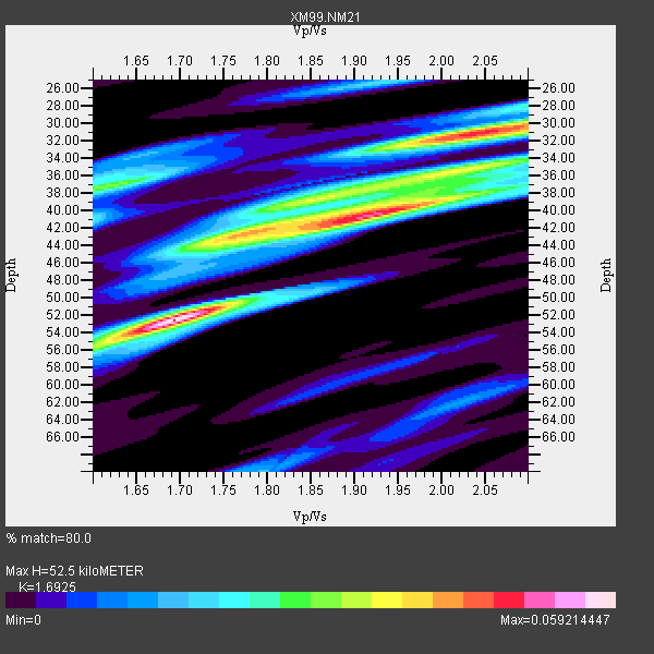
| Thickness Estimate: | 52 km |
| Thickness StdDev: | 8.9 km |
| Vp/Vs Estimate: | 1.69 |
| Vp/Vs StdDev: | 0.13 |
| Vs Estimate: | 3.682 km/s |
| Poisson's Ratio: | 0.23 |
| Peak Value: | 0.06 |
| Assumed Vp: | 6.232 km/s |
| Ps Weight: | 0.33333334 |
| PpPs Weight: | 0.33333334 |
| PsPs Weight: | 0.33333328 |
| Residual Complexity: | 0.872 |
| Nearby stations H: | +- |
| (2.0 deg) Vp/Vs: | +- |
0 with match > 90% ( 0.0 %) and 2 with match > 80% ( 66.666664 %) out of 3.
Download stack as xyz text file.
Azimuth Distribution of Events:

Prior Results for this Station
| Study | Thickness | Vp/Vs | Vp | Vs | Poissons Ratio | Extra |
| EARS | 52 km | 1.69 | 6.232 km/s | 3.682 km/s | 0.23 | |
| Crust2.0 | 38 km | 1.76 | 6.232 km/s | 3.534 km/s | 0.26 | P2,orogen/38km, Alps and Foreland, 2 km seds. |
| Wilson | 41 km | 1.77 | 6.22 km/s | 3.514 km/s | 0.27 | |
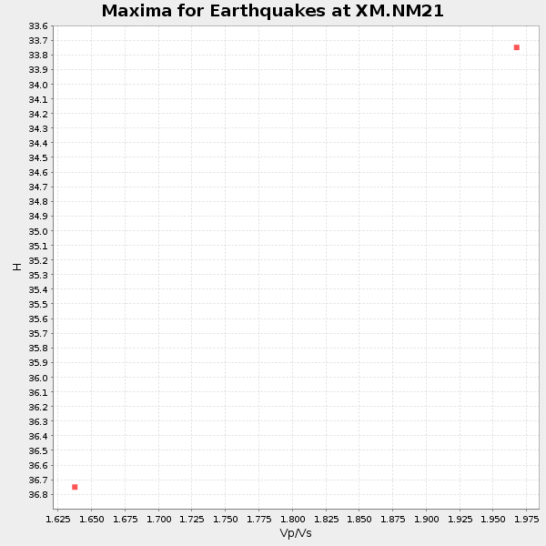
| Global Maxima | 52 km | 1.69 | 6.232 km/s | 3.682 km/s | 0.23 | amp=0.059214447 |
| Local Maxima 1 | 40 km | 1.92 | 6.232 km/s | 3.25 km/s | 0.31 | amp=0.04902706 |
| Local Maxima 2 | 31 km | 2.04 | 6.232 km/s | 3.051 km/s | 0.34 | amp=0.04830035 |
| Local Maxima 3 | 43 km | 1.75 | 6.232 km/s | 3.556 km/s | 0.26 | amp=0.029456742 |
| Local Maxima 4 | 37 km | 1.61 | 6.232 km/s | 3.871 km/s | 0.19 | amp=0.02922625 |
| Predicted Arrivals for vertical incidence (zero ray parameter) | |
| Ps | 5.83 SECOND |
| PpPs | 22.68 SECOND |
| PsPs/PpSs | 28.52 SECOND |
Events Processed for this Station
Download zip of receiver functions as SAC
Plot maxima for each earthquake.
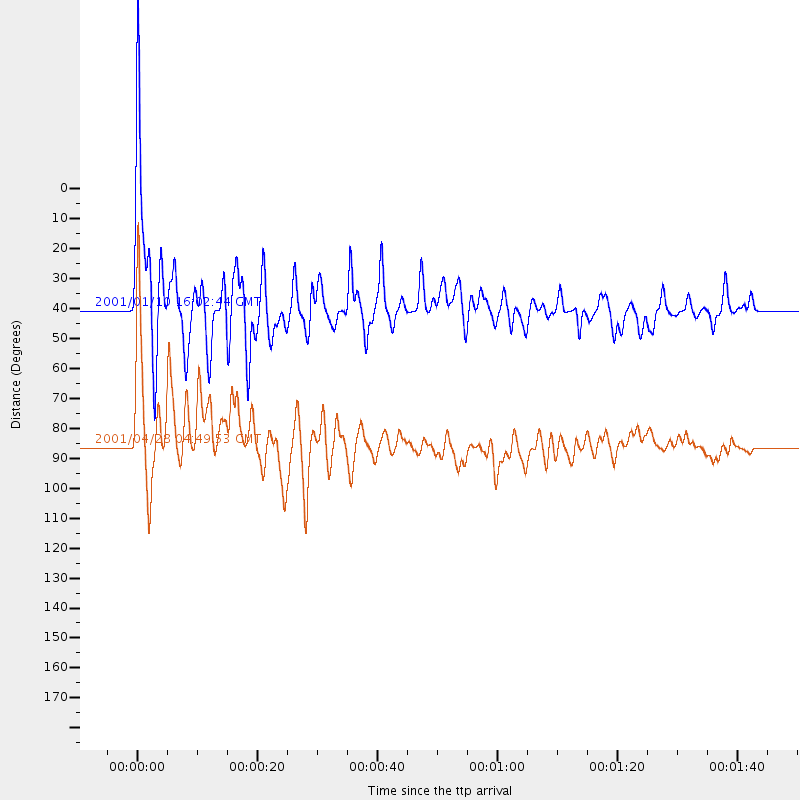
Events Used in the Stack
(2 events)| Radial Match | Distance | Baz | FERegion | Time | Lat/Lon | Depth | Magnitude |
| 87.394165 | 39.6 deg | 320.84 deg | Kodiak Island Region, Alaska | 2001/01/10 16:02:44 GMT | (57.1, -153.2) | 33 km | 6.2 MB, 6.8 MS, 7.1 MW, 6.8 ML |
| 86.17561 | 85.1 deg | 244.664 deg | Fiji Islands Region | 2001/04/28 04:49:53 GMT | (-18.1, -176.9) | 352 km | 6.2 MB, 6.8 MW, 6.8 MW |
Losers
(1 events)| Radial Match | Distance | Baz | FERegion | Time | Lat/Lon | Depth | Magnitude | Reason |
| 96.23421 | 97.3 deg | 248.551 deg | Southeast Of Loyalty Islands | 2001/02/28 13:05:31 GMT | (-22.0, 170.1) | 10 km | 5.8 MB, 6.1 MS, 6.2 MW |
