You are here: Home > Network List > XM99 - Rio Grande Seismic Transect Stations List
> Station NM21 NewMexico21 > Earthquake Result Viewer
NM21 NewMexico21 - Earthquake Result Viewer
| Earthquake location: |
Fiji Islands Region |
| Earthquake latitude/longitude: |
-18.1/-176.9 |
| Earthquake time(UTC): |
2001/04/28 (118) 04:49:53 GMT |
| Earthquake Depth: |
352 km |
| Earthquake Magnitude: |
6.2 MB, 6.8 MW, 6.8 MW |
| Earthquake Catalog/Contributor: |
WHDF/NEIC |
|
| Network: |
XM Rio Grande Seismic Transect |
| Station: |
NM21 NewMexico21 |
| Lat/Lon: |
33.73 N/105.74 W |
| Elevation: |
2000 m |
|
| Distance: |
85.1 deg |
| Az: |
52.348 deg |
| Baz: |
244.664 deg |
| Ray Param: |
0.044094805 |
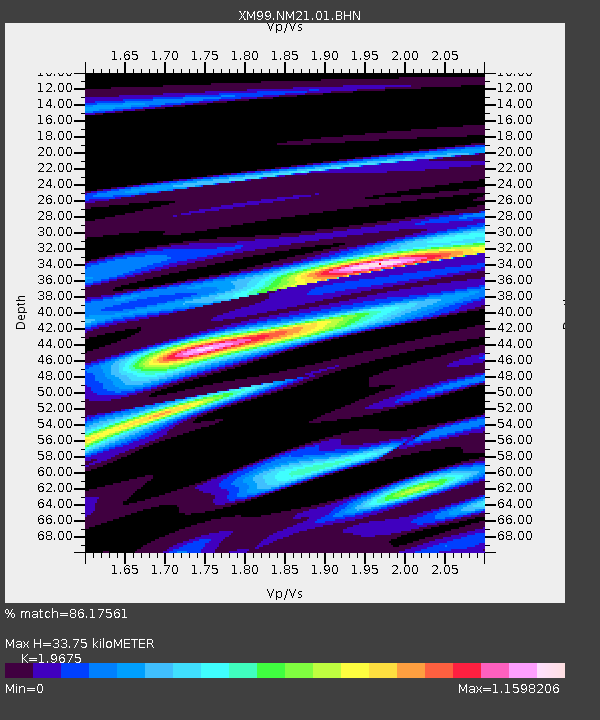
| Estimated Moho Depth: |
33.75 km |
| Estimated Crust Vp/Vs: |
1.97 |
| Assumed Crust Vp: |
6.232 km/s |
| Estimated Crust Vs: |
3.167 km/s |
| Estimated Crust Poisson's Ratio: |
0.33 |
|
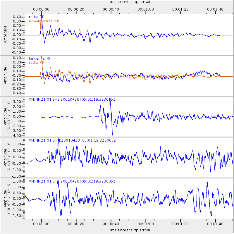
| Radial Match: |
86.17561 % |
| Radial Bump: |
400 |
| Transverse Match: |
54.058834 % |
| Transverse Bump: |
400 |
| SOD ConfigId: |
4714 |
| Insert Time: |
2010-02-26 17:23:27.246 +0000 |
| GWidth: |
2.5 |
| Max Bumps: |
400 |
| Tol: |
0.001 |
|
Signal To Noise
| Channel | StoN | STA | LTA |
| XM:NM21:01:BHN:20010428T05:01:19.323005Z | 0.8502744 | 2.2877502E-7 | 2.6906022E-7 |
| XM:NM21:01:BHE:20010428T05:01:19.323005Z | 1.063928 | 2.1166451E-7 | 1.9894628E-7 |
| XM:NM21:01:BHZ:20010428T05:01:19.323005Z | 10.034698 | 7.597195E-7 | 7.5709266E-8 |
| Arrivals |
| Ps | 5.3 SECOND |
| PpPs | 16 SECOND |
| PsPs/PpSs | 21 SECOND |


